

Files
Download Full Text (16.9 MB)
Subject
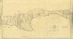
1872 survey depicting the topography and landmarks around the San Luis Obispo Bay.
Description
A survey prepared by the Office of U.S. Coast Survey in 1871 and 1872 reflecting the topography and landmarks surrounding the San Luis Obispo Bay. The map was subsequently updated in 1907 with handwritten notations, including that an article in the December 12, 1907 issue of the S.F. Chronicle reported the wharf for the oil port had been carried away.
Source
National Oceanic and Atmospheric Administration
Format
JPEG
Language
English
Disciplines
Arts and Humanities | Education | Law | Life Sciences | Social and Behavioral Sciences
Original Format
Paper
Document Type
Map
Recommended Citation
"1872 - San Luis Obispo Bay, California" (2018). Groundwater Basin Maps. 32.
https://digitalcommons.csumb.edu/hornbeck_cgb_4/32