

Files
Download Full Text (4.6 MB)
Subject
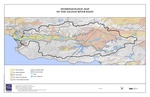
A draft 2016 map depicting the hydrologic and geologic makeup of the Salinas Valley River Basin.
Description
The draft 2016 map prepared by Stetson Engineers, Inc. of the Salinas Valley River Basin depicting river deposits, alluvial deposits, dune sand, alluvial van deposits, Paso Robles Formation, the groundwater basin, county boundary between Monterey and San Luis Obispo counties, the Salinas River as well as lakes and reservoirs.
Source
Stetson Engineers, Inc.
Format
PDF File
Language
English
Disciplines
Arts and Humanities | Education | Law | Social and Behavioral Sciences
Original Format
Paper
Document Type
Map
Recommended Citation
"2016 Hydrogeologic Map of the Salinas River Basin" (2016). Groundwater Basin Maps. 5.
https://digitalcommons.csumb.edu/hornbeck_cgb_4/5
Included in
Arts and Humanities Commons, Education Commons, Law Commons, Social and Behavioral Sciences Commons