

Files
Download Full Text (17.7 MB)
Subject
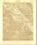
U.S. Geological topographical survey of Jamesburg Quadrangle.
Description
1919 U.S. Geological topographical survey depicting the Jamesburg Quadrangle, Monterey County, California, reflecting landmarks, Salinas River, creeks, ranchos, railways and roads.
Source
Office of the United States Geological Surveys
Format
Language
English
Disciplines
Arts and Humanities | Education | Law | Life Sciences | Social and Behavioral Sciences
Original Format
Paper
Document Type
Map
Recommended Citation
"1920 - Jamesburg Quadrangle Topographical Survey, Monterey County - USGS" (2018). Groundwater Basin Maps. 63.
https://digitalcommons.csumb.edu/hornbeck_cgb_4/63
Included in
Arts and Humanities Commons, Education Commons, Law Commons, Life Sciences Commons, Social and Behavioral Sciences Commons