

Files
Download Full Text (18.6 MB)
Subject
Early map of the United States of Mexico created a few years after Mexico’s independence from Spain.
Description
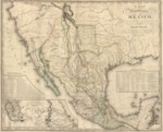
The map depicts the United States of Mexico was created by Henry Schenck Tanner a few years after Span’s acceptance of Mexican independence in 1821. The map reflects the original boundaries of the new country of Mexico extending further north than the present-day border. At that point in time, Mexico included a substantial portion of what is now the southwestern United States and included territory as far north as California, Nevada and Utah. The map depicts mountain ranges, rivers, roads, cities, towns and forts as well as the location of many Native American tribes. It also includes two insert charts -- one that show the distances between various cities and one that is a statistical chart of the Mexican states. There is an insert chart on the bottom left portion of the map that depicts the area from Veracruz and Alvarado to Mexico City.
Source
Library of Congress
Format
JPEG
Language
English
Disciplines
Arts and Humanities | Education | Social and Behavioral Sciences
Original Format
Paper
Document Type
Map
Recommended Citation
"1826 - A map of the United States of Mexico as organized and defined by the several acts of the Congress of that Republic" (2017). Pre-1846 Maps. 10.
https://digitalcommons.csumb.edu/hornbeck_mex_1/10