

Files
Download Full Text (109.3 MB)
Subject
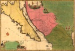
A 1720 map depicting the West Coast of Mexico, interior of the Southwest, Baja California and the island of California.
Description
The 1720 map by Nicolas de Fer contains important information about Spanish missions in Mexico, Native American villages and western river systems. It shows the West Coast of Mexico, interior of the Southwest, Baja California and the island of California. The map was copied from the manuscript 1696 map by Father Eusebio Kino, who traveled throughout the Southwest for over a decade. Although Father Kino concluded by 1701 that California was connected to the mainland, the myth was perpetuated in the present map and was essentially an enlarged edition of De Fer's smaller 1700 map. It is decorated with indigenous people and native wildlife. Contained then new information about missions, Native American Villages, river systems, recording over 350 towns, villages, regions and rivers in California and northern Mexico.
Source
Library of Congress
Format
PDF File
Language
French
Disciplines
Arts and Humanities | Education | Social and Behavioral Sciences
Original Format
Paper
Document Type
Map
Recommended Citation
"1720 - La Californie ou Nouvelle Caroline : teatro de los trabajos, Apostolicos de la Compa. e Jesus en la America Septe." (2017). Pre-1824 Maps. 10.
https://digitalcommons.csumb.edu/hornbeck_spa_1_a/10