

Files
Download
Download Full Text (2.3 MB)
Subject
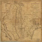
An 1807 map depicting the internal provinces of New Spain.
Description
The 1807 map of New Spain stretches from the Baja Peninsula to Nacogdoches in the east and depicts the provincial boundaries, capitals of provinces or kingdoms, Indian and Spanish villages, and the American Troops route.
Source
Library of Congress
Format
PDF File
Language
English
Disciplines
Arts and Humanities | Education | Social and Behavioral Sciences
Original Format
Paper
Document Type
Map
Recommended Citation
"1807- A Map of the Internal Provinces of New Spain" (2017). Pre-1824 Maps. 12.
https://digitalcommons.csumb.edu/hornbeck_spa_1_a/12