
Files
Download Full Text (40.0 MB)
Subject
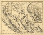
1777 map showing five representations on one sheet of California between 1604 and 1767.
Description
This 1777 map shows five early cartographic perceptions of California and the Gulf of California; Islands, settlements, areas of Native American housing, and notable physical features. Includes some dates of discovery, ranging from roughly 1604 to 1767. The map explores California cartography in the late 18 th century. The 1604 map correctly presumed that the main body of California extended southward to a peninsula. The 1656 map shows California as an island. The 1700 map reattaches California to the mainland. The 1705 map rendered by a Jesuit missionary c. 1705 finally disproved that California was a separate island. The final 176 map depicts with a reasonable accuracy of the Baja California peninsula.
Source
Library or Congress
Format
PDF File
Language
French
Disciplines
Arts and Humanities | Education | Social and Behavioral Sciences
Original Format
Paper
Document Type
Map
Recommended Citation
"1777 - Carte de la Californie : suivant I. la Carte manuscrite de l'Amérique de Mathieu Néron Pecci olen dresses à Florence en 1604, II. Sanson 1656, III. De l'Isle Amérique Sept. 1700, IV. le Pere Kino Jesuite en 1705, V. la Société des Jésuites en 1767." (2017). Pre-1824 Maps. 18.
https://digitalcommons.csumb.edu/hornbeck_spa_1_a/18
