

Files
Download Full Text (2.2 MB)
Subject
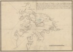
Detailed early map of Puerto de Burcareli, Prince of Wales Island, Alaska
Description
On February 11, 1779, two vessels, the Princesa and the Favorita, commanded by Ignacio de Arteaga and Juan Francisco de la Bodega y Quadra, set sail launching Spain’s third expedition from San Blas, Mexico, to Nueva Galicia (the Pacific Northwest). Their orders were to sail far from the coastline and aim for 70° north latitude and to take formal possession of the land from 50° to 70° north latitude. After an 81-day voyage, they set anchor in the entrance of Puerto de Bucareli situated 55° 17' north latitude on May 3, 1779. They spent six weeks exploring the coastal area and preparing detailed charts of the coastline and many waterways meandering between the islands.
Source
Archivo General Militar de Madrid, Spain
Format
PDF File
Language
Spanish
Disciplines
Education | Social and Behavioral Sciences
Original Format
Paper
Document Type
Map
Recommended Citation
"1779 - Plano de la insigne Entrada de Bucarely, en la Costa Septentrional de la California" (2017). Pre-1824 Maps. 50.
https://digitalcommons.csumb.edu/hornbeck_spa_1_a/50