

Files
Download Full Text (3.8 MB)
Subject
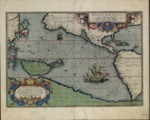
An Abraham Ortelius map focusing exclusively on the Pacific Ocean was based upon German-Flemish cartographer Gerardus Mercator’s world map of 1569 who used information garnered from Portuguese manuscript maps and from the travel accounts of European explorers, including Magellan, Pigafetta and Haklluyt.
Description
This 1589 map was published in the 1592 edition of Abraham Ortelius’ atlas entitled, “Theatrum Orbis Terrarum.” One of the first printed maps to be devoted to the Pacific Ocean, it was based largely upon Gerardus Mercator’s world map of 1569. Mercator’s map contained details from Portuguese manuscript maps, as well as information obtained from the travel accounts of explorers such as Magellan, Pigafetta and Haklluyt. The map reflects the first 75 years of European exploration within the world’s largest body of water albeit shown to be much smaller than the true size of the Pacific Ocean. The map shows the spice-rich islands known as the Moluccas and the Philippines, a region contested at the time by the Dutch, Spanish and Portuguese. The map also depicted islands known today as Japan and Guam (Restiga de Ladrones), Solomons, and New Guinea. Unlike the 1588 Ortelius’ world map that showed New Guinea attached to yet to be explored southern continent Terra Australis, this 1592 map depicts it as detached.
Source
Cartographic and Study Archive, Geographic Center of the Army, Madrid, Spain
Format
JPEG
Language
Latin
Disciplines
Arts and Humanities | Education | Social and Behavioral Sciences
Document Type
Map
Recommended Citation
"1592 - Maris Pacifici, quod vulgo Mar del Zur" (2017). Pre-1824 Maps. 24.
https://digitalcommons.csumb.edu/hornbeck_spa_1_a/24