

Files
Download Full Text (9.1 MB)
Subject
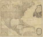
1783 map detailing the new formed United States, British dominions in Canada, French territory of Louisiana, West Indies and Spanish holdings in Mexico, Florida and Central America.
Description
The map was originally published in 1755 and subsequently updated numerous times as more land was explored and land ownership changed. It includes text at the top right corner setting forth the fishing rights of the United States. The lower left corner contains an insert is entitled: “A Passage By Land to California.” An upper left corner insert is entitled: “A Particular map of Baffin and Hudson’s Bay.” Extensive comments by Pownall regarding the lands and territories between the Apalachean (sic) Mountains and the Mississippi River regarding indigenous tribes, sites suitable for factories, alliances and temperaments of tribes and the navigability of river systems. The map was printed for Saver and Bennett in London “as the Act directs” on August 15, 1783.
Source
Archivo General Militar de Madrid
Format
PDF File
Language
English
Disciplines
Arts and Humanities | Education | Social and Behavioral Sciences
Original Format
Paper
Document Type
Map
Recommended Citation
"1783 - New Map of North America with West India Islands, divided according to the Preliminary Articles of Peace, Signed at Versailles, 20, Jan. 1783, wherein are particularly Distinguished The United States, and the Several Provinces, Governments & ca which Compose the British Dominions, Laid down according to the Latest Surveys, and Corrected from the Original Materials of Goverr. Pownall, Membr. of Parlimnt." (2017). Pre-1824 Maps. 28.
https://digitalcommons.csumb.edu/hornbeck_spa_1_a/28