

Files
Download Full Text (1.0 MB)
Subject
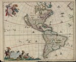
1670 era map by Dutch cartographer, Frederik de Wit, of North and South America with the “California as an island” myth being perpetuated.
Description
A 1670 era map by Dutch cartographer, Frederik de Wit, depicting North and South America with the “California as an island” myth being perpetuated. It shows a non-existent coastline north of California and a misshaped South America. While providing substantial detail of the Eastern regions of Canada and North America, there is little information on the interior of North America. It depicts Dutch possessions, the Iroquois, New Amsterdam, Great Lakes, Chesapeake Bay, Plymouth, as well as vignettes of Indians and Indian villages in South America and animals in North America. Regions for Florida, Canada, Mexico, West Indies and South America are depicted as separate geographic regions. The upper left plaque shows an angel and a female figure bearing a cross. The lower left cartouche depicts natives bringing gold bars and baskets of grain to an Indian chieftain. The map, unlike many similar maps published in the 17th century, shows ships throughout the oceans flanking North and South America. De Wit who was active in the second half of the 17th century published world atlases containing anywhere from 15 to 150 maps – none of which were dated.
Source
Archivo Cartografico y de Estudios Geograficos, Madrid, Spain
Format
JPEG
Language
Latin
Original Format
Paper
Document Type
Map
Recommended Citation
"1670 c. - Novissima et Accuratissima Totius Americae Descriptio" (2017). Pre-1824 Maps. 33.
https://digitalcommons.csumb.edu/hornbeck_spa_1_a/33