

Files
Download Full Text (383 KB)
Subject
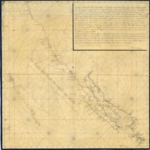
Early map depicting the Mexican West Coast (New Spain), the East and West coast California Peninsula (Baja) and the West Coast of the frontier of America.
Description
This map by Miguel Costanzó depicts a West Coast region of New Spain (Nueva Españal) and the American frontier that extended from Cabo de Corrientes in New Spain to Cabo Blanco (the westernmost point in modern-day Oregon) and the Rio de los Reyes (River of the Kings) immediately to the north of Cabo Blanco. Motivated by news from Europe that the Russians and English were establishing themselves on the coasts of the North Pacific, Following January 1768 issuance of an order by the Viceroy Governor of New Spain, navigators who had previously explored the Sea of the South proceeded to explore the coastal regions of Western New Spain and the American frontier along the Pacific Ocean. The map was compiled from the diaries of the pilot of the packet boats, SM Santa Maria and San Antonio. Additional information was obtained from manuscripts of former missionaries describing the interior and coastal regions of California. Longitude on this map is Tenerise, the meridian used by the Spanish in the 1700s. Appears to be an earlier version of a more refined map published in 1771.
Source
Archivo Cartografico y de Estudios Geograficos, Madrid, Spain
Format
JPEG
Language
Spanish
Disciplines
Arts and Humanities | Education | Social and Behavioral Sciences
Original Format
Paper
Document Type
Map
Recommended Citation
"1770 - Carta reducida del Occeano Asiático nombrado por los Navegantes Mar del Sur - que comprehende la Costa Oriental y Occidental de la Peninsula de la California con el Golfo de su denominación" (2017). Pre-1824 Maps. 37.
https://digitalcommons.csumb.edu/hornbeck_spa_1_a/37