
Files
Download Full Text (3.9 MB)
Subject
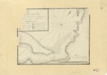
1768 chart by Miguel Constanzó and Joseph de Urrutia depicting the Bay of La Paz and Port of Cortes, Baja Peninsula, Mexico
Description
In 1768 under the order of José de Gálvez, the Inspector General who had been sent to New Spain by King Carlos III, Miguel Constanzó and Joseph de Urrutia mapped the Bay of La Paz and Port of Cortes. Although the La Paz mission was closed in 1748, the port continued to be used on as an anchorage by local miners and salt merchants to load and unload goods. It was also a region abundant with pearls. The chart provides an alphabetical “Explanacion” of the landmarks in this region. The chart also reflects measurements in terms of depth, as well as latitude and longitude.
Source
Archivo Cartografico y de Estudios Geograficos, Madrid, Spain
Format
JPEG
Disciplines
Arts and Humanities | Education | Social and Behavioral Sciences
Original Format
Paper
Document Type
Map
Recommended Citation
"1768 c. - Puerto de La Paz - sobre la Costa Oriental de California debaro de la Latitud de 24 grs 20 ms" (2017). Pre-1824 Maps. 46.
https://digitalcommons.csumb.edu/hornbeck_spa_1_a/46
