

Files
Download Full Text (1.4 MB)
Subject
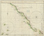
Early map of the coastline from San Blas, New Spain, north to Cabo Mendocíno, Alta California.
Description
Under orders from Don Jose de Gálvez, between 1768 and 1770, Miguel Constanzó explored the coastline of the California (Baja) Peninsula and Alta California with a two-fold purpose: 1) to correct existing navigational charts, and 2) to investigate and develop plans for the ports of San Diego and Monterey. He was also directed, if possible, to investigate the San Francisco Bay region and develop plans for that area too. His explorations resulted in four maps that included a plan focused on the coastal region around the Channel of Santa Bárbara. The map roughly depicts the coastline from San Blas, New Spain, north to Cabo Mendocíno, Alta California as reflected by the lack of detail surrounding either the Monterey Bay or San Francisco Bay.
Source
Archivo General Militar de Madrid, Spain
Format
PDF File
Language
Spanish
Disciplines
Arts and Humanities | Education | Social and Behavioral Sciences
Original Format
Paper
Document Type
Map
Recommended Citation
"1769 - Plano de la Costa del Sur corregido hasta la Canal de Santa Barbara" (2017). Pre-1824 Maps. 51.
https://digitalcommons.csumb.edu/hornbeck_spa_1_a/51