
Files
Download Full Text (1.6 MB)
Subject
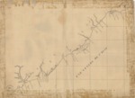
Early California map reflecting the coastline from the northern Baja Peninsula to Bodega Bay and the first 18 missions and presidios established in Alta California
Description
This undated, hand-drawn map reflects the coastline beginning in the northern portion of the Baja Peninsula going as far north as Puerto de la Bodega. It shows the approximate location of the 18 missions established in Alta California by 1797. It does not show missions located north of the San Francisco Bay – San Rafael Arcángel and San Francisco de Solano established in 1817 and 1823 respectively. Mission San Luis Rey de Francia established in 1798 and located north of San Diego is not shown on the map, hence one can extrapolate that the map was probably created in late 1797. The map depicts with single small squares the four presidios located in San Diego, Santa Barbara, Monterey and San Francisco. The missions and presidios have been assigned an alphabetical designation suggesting that a legend had been or was going to be prepared that would accompany the map or be placed on the face of the map. There are two symbols consisting of a group of small squares that are assigned numerical designations “1” and “2” – one located near Mission Santa Clara de Asís and the other located between missions San Fernando Rey de España and San Gabriel Arcángel.
Source
Archivo General Militar de Madrid, Spain
Format
PDF File
Language
Spanish
Disciplines
Arts and Humanities | Education | Social and Behavioral Sciences
Original Format
Paper
Document Type
Map
Recommended Citation
"1797 c. - Mar Grande de San. Blas" (2017). Pre-1824 Maps. 48.
https://digitalcommons.csumb.edu/hornbeck_spa_1_a/48
