

Files
Download Full Text (480 KB)
Subject
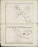
Published in 1797, two maps on one page depicting the harbors of San Diego, California dated 1777 and of San Blas, Mexico dated 1782.
Description
The two maps by Jean-Francois de la Perouse are based on surveys made by Juan Pantoja y Arriaga, a captain of the Manila trade for Spain. Derived from Pantoja's manuscript, the charts were published after his death in the "Atlas du Voyage de la Perouse 1785-1788". Locations identified around San Diego, California included: Presidio de St. Diego, the 'faux port', Pointe des Morts, Rancherie de las Choyas, Pointe St. Augustin, Rancherie ou Village d'Indiens nomme de la Pointe, Pointe St. Joseph, Pointe St. Michel, Petite Port de St Jean, Pointe Guizarros, and Pointe de la Colline. Port de San Blas was used by Spain's Navy as a naval base beginning in 1768 and it served for several decades as a base of operations for Spanish expeditions to the Pacific Northwest, as well as for supplying the Spanish missions.
Source
Archivo Cartografico y de Estudios Geograficos, Madrid, Spain
Format
JPEG
Language
French
Disciplines
Arts and Humanities | Education | Social and Behavioral Sciences
Original Format
Paper
Document Type
Map
Recommended Citation
"1797 - Plan du Port en St. Diego in Californie, 1782 - Plan du Port de St. Blas, 1777" (2017). Pre-1824 Maps. 25.
https://digitalcommons.csumb.edu/hornbeck_spa_1_a/25