

Printing is not supported at the primary Gallery Thumbnail page. Please first navigate to a specific Image before printing.
-
![1825 - Mission Spheres of Influence Circa 1825, Salinas Valley and Vicinity [Draft]](https://digitalcommons.csumb.edu/hornbeck_spa_1_b/1010/thumbnail.jpg "1825 - Mission Spheres of Influence Circa 1825, Salinas Valley and Vicinity [Draft]")
1825 - Mission Spheres of Influence Circa 1825, Salinas Valley and Vicinity [Draft]
Map depicting mission spheres of influence in approximately 1825 in the Salinas Valley and surrounding vicinities. Supplemental downloadable August 4, 2017 memorandum regarding the Motivations for Mapping "Spanish Mission Sphere of Influence."
-

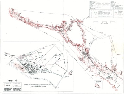
1993 Map of Mission San Antonio De Padua National Historic Landmark District
The March 5, 1993 map of Mission San Antonio De Padua National Historic Landmark District with mission site plan depicts national historic landmarks, historic and archeological sites, Mission Zanja [Aqueduct] System, as well as buildings and structures.