

Files
Download Full Text (22.6 MB)
Subject
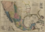
The 1847 map depicting the United States of Mexico and the southern United States.
Description
This 1847 map depicts the United States of Mexico; Alta California, as well as the souther portion of the United States including Texas, Missouri, Arkansas, Louisiana, Georgia and Florida. Inserts in the map include a distance chart and list, the Chart of the Bay of Vera Curz, map showing the battle grounds of May 8 and 9 1846, Tampico and it's environs and the Plan of Monterey and its environs.
Source
Library of Congress
Format
JPG File
Language
Spanish and English
Disciplines
Arts and Humanities | Education | Social and Behavioral Sciences
Original Format
Paper
Document Type
Map
Recommended Citation
"1847 - Mapa de los Estados Unidos de Méjico, California &c. : segun lo organizado y de nido por las varias actas del congreso de dicha Républica y construido por las mejores autoridades." (2017). American Period Maps. 11.
https://digitalcommons.csumb.edu/hornbeck_usa_1/11