

Tomales y Baulenes or Bolinas (García), Diseño 114, GLO No. 38, Marin County, and associated historical documents.
Files
Download Full Text
Download WPA Abstract, Tomales y Baulenes or Bolinas (García), GLO 38 (1.4 MB)
Download Bancroft Notes, Tomales y Baulenes or Bolinas (García), GLO 38 (27 KB)
Download BLM Patent, Oct. 18, 1883, Tomales y Baulenes or Bolinas (García), GLO 38 (7.7 MB)
Download BLM Land Patent Details, Tomales y Baulenes or Bolinas (García), GLO 38 (110 KB)
Download BLM CDI Details, Tomales y Baulenes or Bolinas (García), GLO 38 (242 KB)
Download BLM Survey, July 22, 1880, Tomales y Baulenes or Bolinas (García), GLO 38 (13.6 MB)
Subject
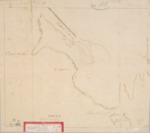
Diseños - Spanish/Mexican land grant map.
Work Progress Administration Abstract (WPA Abstract) – Historical details of a Spanish-Mexican land grant that was subsequently patented by the U. S. Government.
Bancroft Notes – Summary of Bancroft Archives information regarding a private land claim.
Bancroft Diseños -- Spanish/Mexican land grant map.
Bancroft Plat/Map/Sketch -- U.S. Surveyor General rancho plat or sketch.
BLM Land Grant Patent – U.S. Government issued document certifying a Private Land Claim.
BLM Land Patent Detail Sheet – BLM Accession number document that provides patent information.
BLM CDI Detail Sheet – CDI Doc ID document that provides patent information.
BLM Survey – Office of the U.S. Surveyor General plat(s) detailing the specific boundaries of land.
Description
Diseños - Hand-drawn Spanish-Mexican map demonstrating the physical boundaries of land granted to Mexican citizens by the Spanish or Mexican.
Work Progress Administration Abstract (WPA Abstract) – A summary document prepared in 1938 under the U.S. Work Progress Administration program detailing the history of a rancho beginning with the Spanish-American land through the U.S. patenting process.
Bancroft Notes – Document detailing information and documents regarding a rancho found in the Bancroft Archives.
Bancroft Diseños – Hand-drawn Spanish-Mexican map demonstrating the physical boundaries of land granted to Mexican citizens by the Spanish or Mexican governments used in the U.S. District Court proceedings.
Bancroft Plat/Map/Survey – A plat, map or survey of the patented rancho prepared by the U.S. Surveyor General.
BLM Land Grant Patent – Hand-written document issued by the U.S. Government providing legal ownership of land previously granted by the Spanish or Mexican government.
BLM Land Patent Detail Sheet – Document using the BLM accession number that provides specific information regarding the patented land of a rancho.
BLM CDI Detail Sheet - Document using the CDI Doc ID that provides specific information concerning the patented land of a rancho.
BLM Survey(s) – Plat(s) prepared by the Office of the U.S. Surveyor General detailing the boundaries of the rancho.
Source
WPA Abstract – David Hornbeck, Ph.D.; Bancroft documents – Bancroft Archives; BLM Patent, BLM Land Patent Details, BLM CDI Details, BLM Survey(s) – U. S. Bureau of Land Management.
Format
Language
Spanish; English
Disciplines
Arts and Humanities | Education | Law | Life Sciences | Social and Behavioral Sciences
Original Format
Paper
Document Type
Map
Recommended Citation
"Tomales y Baulenes or Bolinas (García), Diseño 114, GLO No. 38, Marin County, and associated historical documents." (2018). Marin County. 18.
https://digitalcommons.csumb.edu/hornbeck_usa_4_a_mac/18