

-

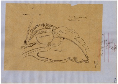
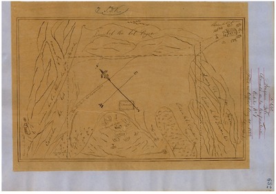
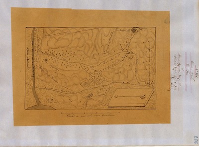
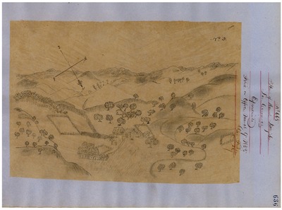
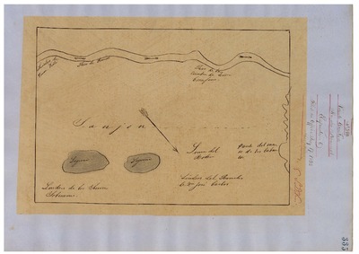
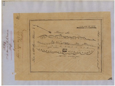
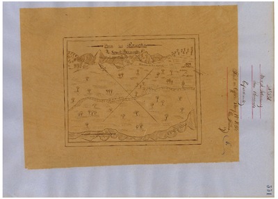
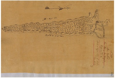
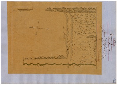
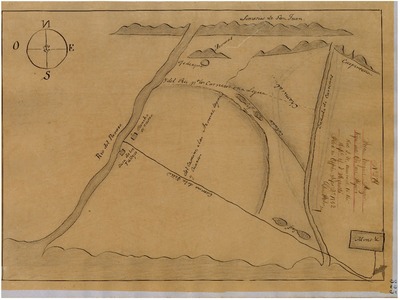
Guadalupe y Llanitos de Los Correos, GLO No. 273, Monterey County, Diseños and associated historical documents.
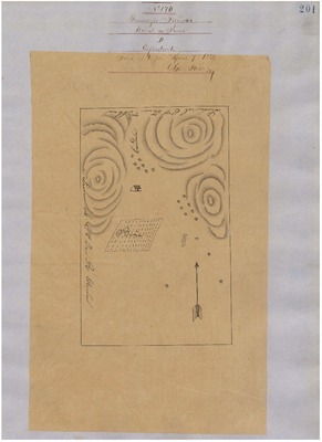
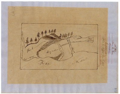
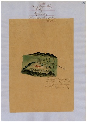
Diseños - Hand-drawn Spanish-Mexican map demonstrating the physical boundaries of land granted to Mexican citizens by the Spanish or Mexican.
Expediente – Hand-written Spanish-Mexican land grant document issued to Mexican citizens in Alta California for land in Alta-California.
Work Progress Administration Abstract (WPA Abstract) – A summary document prepared in 1938 under the Work Progress Administration program detailing the history of a rancho beginning with the Spanish-American land through the U.S. patenting process.
Hoffman Notes -- Summary of information concerning claims made for the Rancho lands from the Appendix listing Table of Land Claims in the Reports of Land Cases by Ogden Hoffman, Volume I, 1862.
Hoffman Table of Land Claims Appendix, Reports on Land Cases, Vol. I, 1862, p. 83 Ogden Hoffman; summary of information concerning claims made for the Rancho lands.
Hornbeck Rancho Detail Sheet – A summary sheet generated from a land patent database that details the history of a rancho, along with the various state and federal agency record numbers relating to the rancho.
Bancroft Notes – Document detailing information and documents regarding a particular rancho found in the Bancroft Archives.
Bancroft Diseños – Hand-drawn Spanish-Mexican map demonstrating the physical boundaries of land granted to Mexican citizens by the Spanish or Mexican governments used in the U.S. District Court proceedings.
Bancroft Plat – A plat of the patented rancho prepared by the U.S. Surveyor General.
BLM Land Grant Patent – Hand-written document issued by the U.S. Government providing legal ownership of land previously granted by the Spanish or Mexican government.
BLM Land Patent Detail Sheet – Document using the BLM accession number that provides specific information regarding the patented land of a rancho.
BLM CDI Detail Sheet - Document using the CDI Doc ID that provides specific information concerning the patented land of a rancho.
BLM Survey(s) – Plat(s) prepared by the Office of the U.S. Surveyor General detailing the boundaries of the rancho.
Monterey County Assessor’s Office Original Map/Plat – Plat prepared for the Monterey County Assessor’s Office detailing the boundaries of the rancho and any subdivision made within the boundaries of the rancho.
Monterey County Recorder’s Office – Recorded rancho land patent.
-

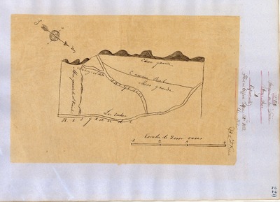
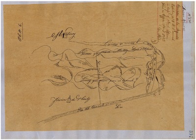
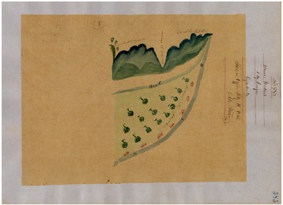
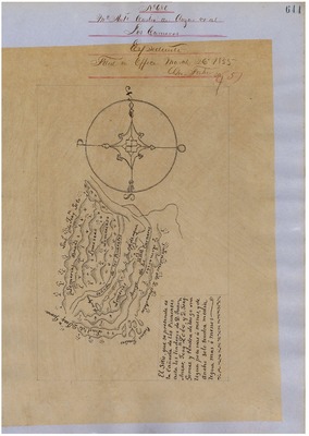
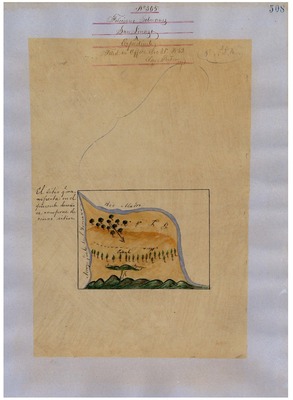
James Meadows, Diseños GLO No. 284, Monterey County, Diseños and associated historical documents.
Diseños - Hand-drawn Spanish-Mexican map demonstrating the physical boundaries of land granted to Mexican citizens by the Spanish or Mexican.
Expediente – Hand-written Spanish-Mexican land grant document issued to Mexican citizens in Alta California for land in Alta-California.
Work Progress Administration Abstract (WPA Abstract) – A summary document prepared in 1938 under the Work Progress Administration program detailing the history of a rancho beginning with the Spanish-American land through the U.S. patenting process.
Hoffman Notes -- Summary of information concerning claims made for the Rancho lands from the Appendix listing Table of Land Claims in the Reports of Land Cases by Ogden Hoffman, Volume I, 1862.
Hoffman Table of Land Claims Appendix, Reports on Land Cases, Vol. I, 1862, p. 83 Ogden Hoffman; summary of information concerning claims made for the Rancho lands.
Hornbeck Rancho Detail Sheet – A summary sheet generated from a land patent database that details the history of a rancho, along with the various state and federal agency record numbers relating to the rancho.
Bancroft Notes – Document detailing information and documents regarding a particular rancho found in the Bancroft Archives.
Bancroft Diseños – Hand-drawn Spanish-Mexican map demonstrating the physical boundaries of land granted to Mexican citizens by the Spanish or Mexican governments used in the U.S. District Court proceedings.
Bancroft Plat – A plat of the patented rancho prepared by the U.S. Surveyor General.
BLM Land Grant Patent – Hand-written document issued by the U.S. Government providing legal ownership of land previously granted by the Spanish or Mexican government.
BLM Land Patent Detail Sheet – Document using the BLM accession number that provides specific information regarding the patented land of a rancho.
BLM CDI Detail Sheet - Document using the CDI Doc ID that provides specific information concerning the patented land of a rancho.
BLM Survey(s) – Plat(s) prepared by the Office of the U.S. Surveyor General detailing the boundaries of the rancho.
Monterey County Assessor’s Office Original Map/Plat – Plat prepared for the Monterey County Assessor’s Office detailing the boundaries of the rancho and any subdivision made within the boundaries of the rancho.
Monterey County Recorder’s Office – Recorded rancho land patent.
-

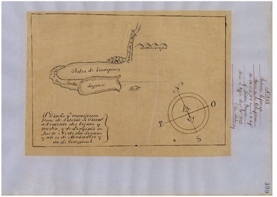
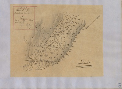
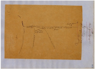
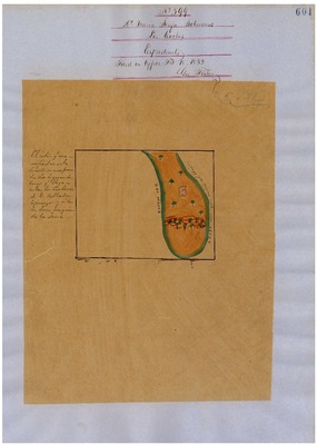
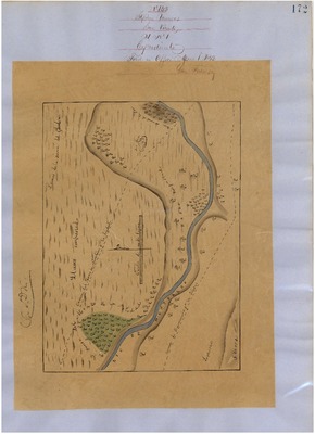
Las Salinas, GLO No. 257, Monterey County, Diseños and associated historical documents.
Diseños - Hand-drawn Spanish-Mexican map demonstrating the physical boundaries of land granted to Mexican citizens by the Spanish or Mexican.
Expediente – Hand-written Spanish-Mexican land grant document issued to Mexican citizens in Alta California for land in Alta-California.
Work Progress Administration Abstract (WPA Abstract) – A summary document prepared in 1938 under the Work Progress Administration program detailing the history of a rancho beginning with the Spanish-American land through the U.S. patenting process.
Hoffman Notes -- Summary of information concerning claims made for the Rancho lands from the Appendix listing Table of Land Claims in the Reports of Land Cases by Ogden Hoffman, Volume I, 1862.
Hoffman Table of Land Claims Appendix, Reports on Land Cases, Vol. I, 1862, p. 83 Ogden Hoffman; summary of information concerning claims made for the Rancho lands.
Hornbeck Rancho Detail Sheet – A summary sheet generated from a land patent database that details the history of a rancho, along with the various state and federal agency record numbers relating to the rancho.
Bancroft Notes – Document detailing information and documents regarding a particular rancho found in the Bancroft Archives.
Bancroft Diseños – Hand-drawn Spanish-Mexican map demonstrating the physical boundaries of land granted to Mexican citizens by the Spanish or Mexican governments used in the U.S. District Court proceedings.
Bancroft Plat – A plat of the patented rancho prepared by the U.S. Surveyor General.
BLM Land Grant Patent – Hand-written document issued by the U.S. Government providing legal ownership of land previously granted by the Spanish or Mexican government.
BLM Land Patent Detail Sheet – Document using the BLM accession number that provides specific information regarding the patented land of a rancho.
BLM CDI Detail Sheet - Document using the CDI Doc ID that provides specific information concerning the patented land of a rancho.
BLM Survey(s) – Plat(s) prepared by the Office of the U.S. Surveyor General detailing the boundaries of the rancho.
Monterey County Assessor’s Office Original Map/Plat – Plat prepared for the Monterey County Assessor’s Office detailing the boundaries of the rancho and any subdivision made within the boundaries of the rancho.
Monterey County Recorder’s Office – Recorded rancho land patent.
-

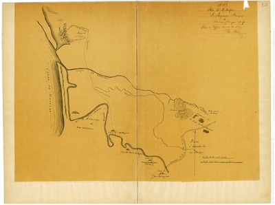
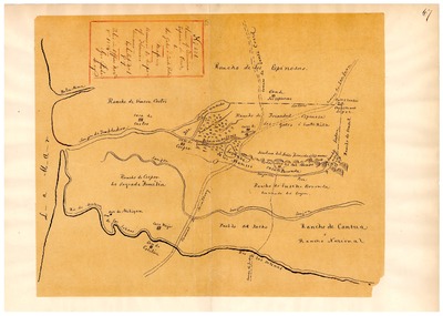
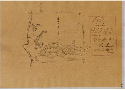
Llano de Buena Vista, GLO No. 226, Monterey County, Diseños and associated historical documents.
Diseños - Hand-drawn Spanish-Mexican map demonstrating the physical boundaries of land granted to Mexican citizens by the Spanish or Mexican.
Expediente – Hand-written Spanish-Mexican land grant document issued to Mexican citizens in Alta California for land in Alta-California.
Work Progress Administration Abstract (WPA Abstract) – A summary document prepared in 1938 under the Work Progress Administration program detailing the history of a rancho beginning with the Spanish-American land through the U.S. patenting process.
Hoffman Notes -- Summary of information concerning claims made for the Rancho lands from the Appendix listing Table of Land Claims in the Reports of Land Cases by Ogden Hoffman, Volume I, 1862.
Hoffman Table of Land Claims Appendix, Reports on Land Cases, Vol. I, 1862, p. 83 Ogden Hoffman; summary of information concerning claims made for the Rancho lands.
Hornbeck Rancho Detail Sheet – A summary sheet generated from a land patent database that details the history of a rancho, along with the various state and federal agency record numbers relating to the rancho.
Bancroft Notes – Document detailing information and documents regarding a particular rancho found in the Bancroft Archives.
Bancroft Diseños – Hand-drawn Spanish-Mexican map demonstrating the physical boundaries of land granted to Mexican citizens by the Spanish or Mexican governments used in the U.S. District Court proceedings.
Bancroft Plat – A plat of the patented rancho prepared by the U.S. Surveyor General.
BLM Land Grant Patent – Hand-written document issued by the U.S. Government providing legal ownership of land previously granted by the Spanish or Mexican government.
BLM Land Patent Detail Sheet – Document using the BLM accession number that provides specific information regarding the patented land of a rancho.
BLM CDI Detail Sheet - Document using the CDI Doc ID that provides specific information concerning the patented land of a rancho.
BLM Survey(s) – Plat(s) prepared by the Office of the U.S. Surveyor General detailing the boundaries of the rancho.
Monterey County Assessor’s Office Original Map/Plat – Plat prepared for the Monterey County Assessor’s Office detailing the boundaries of the rancho and any subdivision made within the boundaries of the rancho.
Monterey County Recorder’s Office – Recorded rancho land patent.
-
, GLO No. 244, Monterey County, Diseños and associated historical documents.")
Los Carneros (Littlejohn), GLO No. 244, Monterey County, Diseños and associated historical documents.
Diseños - Hand-drawn Spanish-Mexican map demonstrating the physical boundaries of land granted to Mexican citizens by the Spanish or Mexican.
Expediente – Hand-written Spanish-Mexican land grant document issued to Mexican citizens in Alta California for land in Alta-California.
Work Progress Administration Abstract (WPA Abstract) – A summary document prepared in 1938 under the Work Progress Administration program detailing the history of a rancho beginning with the Spanish-American land through the U.S. patenting process.
Hoffman Notes -- Summary of information concerning claims made for the Rancho lands from the Appendix listing Table of Land Claims in the Reports of Land Cases by Ogden Hoffman, Volume I, 1862.
Hoffman Table of Land Claims Appendix, Reports on Land Cases, Vol. I, 1862, p. 83 Ogden Hoffman; summary of information concerning claims made for the Rancho lands.
Hornbeck Rancho Detail Sheet – A summary sheet generated from a land patent database that details the history of a rancho, along with the various state and federal agency record numbers relating to the rancho.
Bancroft Notes – Document detailing information and documents regarding a particular rancho found in the Bancroft Archives.
Bancroft Diseños – Hand-drawn Spanish-Mexican map demonstrating the physical boundaries of land granted to Mexican citizens by the Spanish or Mexican governments used in the U.S. District Court proceedings.
Bancroft Plat – A plat of the patented rancho prepared by the U.S. Surveyor General.
BLM Land Grant Patent – Hand-written document issued by the U.S. Government providing legal ownership of land previously granted by the Spanish or Mexican government.
BLM Land Patent Detail Sheet – Document using the BLM accession number that provides specific information regarding the patented land of a rancho.
BLM CDI Detail Sheet - Document using the CDI Doc ID that provides specific information concerning the patented land of a rancho.
BLM Survey(s) – Plat(s) prepared by the Office of the U.S. Surveyor General detailing the boundaries of the rancho.
Monterey County Assessor’s Office Original Map/Plat – Plat prepared for the Monterey County Assessor’s Office detailing the boundaries of the rancho and any subdivision made within the boundaries of the rancho.
Monterey County Recorder’s Office – Recorded rancho land patent.
-
, GLO No. 246, Monterey County, Diseños and associated historical documents.")
Los Carneros (McDougal), GLO No. 246, Monterey County, Diseños and associated historical documents.
Diseños - Hand-drawn Spanish-Mexican map demonstrating the physical boundaries of land granted to Mexican citizens by the Spanish or Mexican.
Expediente – Hand-written Spanish-Mexican land grant document issued to Mexican citizens in Alta California for land in Alta-California.
Work Progress Administration Abstract (WPA Abstract) – A summary document prepared in 1938 under the Work Progress Administration program detailing the history of a rancho beginning with the Spanish-American land through the U.S. patenting process.
Hoffman Notes -- Summary of information concerning claims made for the Rancho lands from the Appendix listing Table of Land Claims in the Reports of Land Cases by Ogden Hoffman, Volume I, 1862.
Hoffman Table of Land Claims Appendix, Reports on Land Cases, Vol. I, 1862, p. 83 Ogden Hoffman; summary of information concerning claims made for the Rancho lands.
Hornbeck Rancho Detail Sheet – A summary sheet generated from a land patent database that details the history of a rancho, along with the various state and federal agency record numbers relating to the rancho.
Bancroft Notes – Document detailing information and documents regarding a particular rancho found in the Bancroft Archives.
Bancroft Diseños – Hand-drawn Spanish-Mexican map demonstrating the physical boundaries of land granted to Mexican citizens by the Spanish or Mexican governments used in the U.S. District Court proceedings.
Bancroft Plat – A plat of the patented rancho prepared by the U.S. Surveyor General.
BLM Land Grant Patent – Hand-written document issued by the U.S. Government providing legal ownership of land previously granted by the Spanish or Mexican government.
BLM Land Patent Detail Sheet – Document using the BLM accession number that provides specific information regarding the patented land of a rancho.
BLM CDI Detail Sheet - Document using the CDI Doc ID that provides specific information concerning the patented land of a rancho.
BLM Survey(s) – Plat(s) prepared by the Office of the U.S. Surveyor General detailing the boundaries of the rancho.
Monterey County Assessor’s Office Original Map/Plat – Plat prepared for the Monterey County Assessor’s Office detailing the boundaries of the rancho and any subdivision made within the boundaries of the rancho.
Monterey County Recorder’s Office – Recorded rancho land patent.
-
, GLO No. 296, Monterey County, Diseños and associated historical documents.")
Los Coches (Soberances), GLO No. 296, Monterey County, Diseños and associated historical documents.
Diseños - Hand-drawn Spanish-Mexican map demonstrating the physical boundaries of land granted to Mexican citizens by the Spanish or Mexican.
Expediente – Hand-written Spanish-Mexican land grant document issued to Mexican citizens in Alta California for land in Alta-California.
Work Progress Administration Abstract (WPA Abstract) – A summary document prepared in 1938 under the Work Progress Administration program detailing the history of a rancho beginning with the Spanish-American land through the U.S. patenting process.
Hoffman Notes -- Summary of information concerning claims made for the Rancho lands from the Appendix listing Table of Land Claims in the Reports of Land Cases by Ogden Hoffman, Volume I, 1862.
Hoffman Table of Land Claims Appendix, Reports on Land Cases, Vol. I, 1862, p. 83 Ogden Hoffman; summary of information concerning claims made for the Rancho lands.
Hornbeck Rancho Detail Sheet – A summary sheet generated from a land patent database that details the history of a rancho, along with the various state and federal agency record numbers relating to the rancho.
Bancroft Notes – Document detailing information and documents regarding a particular rancho found in the Bancroft Archives.
Bancroft Diseños – Hand-drawn Spanish-Mexican map demonstrating the physical boundaries of land granted to Mexican citizens by the Spanish or Mexican governments used in the U.S. District Court proceedings.
Bancroft Plat – A plat of the patented rancho prepared by the U.S. Surveyor General.
BLM Land Grant Patent – Hand-written document issued by the U.S. Government providing legal ownership of land previously granted by the Spanish or Mexican government.
BLM Land Patent Detail Sheet – Document using the BLM accession number that provides specific information regarding the patented land of a rancho.
BLM CDI Detail Sheet - Document using the CDI Doc ID that provides specific information concerning the patented land of a rancho.
BLM Survey(s) – Plat(s) prepared by the Office of the U.S. Surveyor General detailing the boundaries of the rancho.
Monterey County Assessor’s Office Original Map/Plat – Plat prepared for the Monterey County Assessor’s Office detailing the boundaries of the rancho and any subdivision made within the boundaries of the rancho.
Monterey County Recorder’s Office – Recorded rancho land patent.
-

Los Gatos or Santa Rita, GLO No. 253, Monterey County, Diseños and associated historical documents.
Diseños - Hand-drawn Spanish-Mexican map demonstrating the physical boundaries of land granted to Mexican citizens by the Spanish or Mexican.
Expediente – Hand-written Spanish-Mexican land grant document issued to Mexican citizens in Alta California for land in Alta-California.
Work Progress Administration Abstract (WPA Abstract) – A summary document prepared in 1938 under the Work Progress Administration program detailing the history of a rancho beginning with the Spanish-American land through the U.S. patenting process.
Hoffman Notes -- Summary of information concerning claims made for the Rancho lands from the Appendix listing Table of Land Claims in the Reports of Land Cases by Ogden Hoffman, Volume I, 1862.
Hoffman Table of Land Claims Appendix, Reports on Land Cases, Vol. I, 1862, p. 83 Ogden Hoffman; summary of information concerning claims made for the Rancho lands.
Hornbeck Rancho Detail Sheet – A summary sheet generated from a land patent database that details the history of a rancho, along with the various state and federal agency record numbers relating to the rancho.
Bancroft Notes – Document detailing information and documents regarding a particular rancho found in the Bancroft Archives.
Bancroft Diseños – Hand-drawn Spanish-Mexican map demonstrating the physical boundaries of land granted to Mexican citizens by the Spanish or Mexican governments used in the U.S. District Court proceedings.
Bancroft Plat – A plat of the patented rancho prepared by the U.S. Surveyor General.
BLM Land Grant Patent – Hand-written document issued by the U.S. Government providing legal ownership of land previously granted by the Spanish or Mexican government.
BLM Land Patent Detail Sheet – Document using the BLM accession number that provides specific information regarding the patented land of a rancho.
BLM CDI Detail Sheet - Document using the CDI Doc ID that provides specific information concerning the patented land of a rancho.
BLM Survey(s) – Plat(s) prepared by the Office of the U.S. Surveyor General detailing the boundaries of the rancho.
Monterey County Assessor’s Office Original Map/Plat – Plat prepared for the Monterey County Assessor’s Office detailing the boundaries of the rancho and any subdivision made within the boundaries of the rancho.
Monterey County Recorder’s Office – Recorded rancho land patent.
-
, GLO No. 289, Monterey County, Diseños and associated historical documents.")
Los Laureles (Boronda), GLO No. 289, Monterey County, Diseños and associated historical documents.
: Diseños - Hand-drawn Spanish-Mexican map demonstrating the physical boundaries of land granted to Mexican citizens by the Spanish or Mexican.
Expediente – Hand-written Spanish-Mexican land grant document issued to Mexican citizens in Alta California for land in Alta-California.
Work Progress Administration Abstract (WPA Abstract) – A summary document prepared in 1938 under the Work Progress Administration program detailing the history of a rancho beginning with the Spanish-American land through the U.S. patenting process.
Hoffman Notes -- Summary of information concerning claims made for the Rancho lands from the Appendix listing Table of Land Claims in the Reports of Land Cases by Ogden Hoffman, Volume I, 1862.
Hoffman Table of Land Claims Appendix, Reports on Land Cases, Vol. I, 1862, p. 83 Ogden Hoffman; summary of information concerning claims made for the Rancho lands.
Hornbeck Rancho Detail Sheet – A summary sheet generated from a land patent database that details the history of a rancho, along with the various state and federal agency record numbers relating to the rancho.
Bancroft Notes – Document detailing information and documents regarding a particular rancho found in the Bancroft Archives.
Bancroft Diseños – Hand-drawn Spanish-Mexican map demonstrating the physical boundaries of land granted to Mexican citizens by the Spanish or Mexican governments used in the U.S. District Court proceedings.
Bancroft Plat – A plat of the patented rancho prepared by the U.S. Surveyor General.
BLM Land Grant Patent – Hand-written document issued by the U.S. Government providing legal ownership of land previously granted by the Spanish or Mexican government.
BLM Land Patent Detail Sheet – Document using the BLM accession number that provides specific information regarding the patented land of a rancho.
BLM CDI Detail Sheet - Document using the CDI Doc ID that provides specific information concerning the patented land of a rancho.
BLM Survey(s) – Plat(s) prepared by the Office of the U.S. Surveyor General detailing the boundaries of the rancho.
Monterey County Assessor’s Office Original Map/Plat – Plat prepared for the Monterey County Assessor’s Office detailing the boundaries of the rancho and any subdivision made within the boundaries of the rancho.
Monterey County Recorder’s Office – Recorded rancho land patent.
-
, GLO No. 285, Monterey County, Diseños and associated historical documents.")
Los Laureles (Ransom), GLO No. 285, Monterey County, Diseños and associated historical documents.
Diseños - Hand-drawn Spanish-Mexican map demonstrating the physical boundaries of land granted to Mexican citizens by the Spanish or Mexican.
Expediente – Hand-written Spanish-Mexican land grant document issued to Mexican citizens in Alta California for land in Alta-California.
Work Progress Administration Abstract (WPA Abstract) – A summary document prepared in 1938 under the Work Progress Administration program detailing the history of a rancho beginning with the Spanish-American land through the U.S. patenting process.
Hoffman Notes -- Summary of information concerning claims made for the Rancho lands from the Appendix listing Table of Land Claims in the Reports of Land Cases by Ogden Hoffman, Volume I, 1862.
Hoffman Table of Land Claims Appendix, Reports on Land Cases, Vol. I, 1862, p. 83 Ogden Hoffman; summary of information concerning claims made for the Rancho lands.
Hornbeck Rancho Detail Sheet – A summary sheet generated from a land patent database that details the history of a rancho, along with the various state and federal agency record numbers relating to the rancho.
Bancroft Notes – Document detailing information and documents regarding a particular rancho found in the Bancroft Archives.
Bancroft Diseños – Hand-drawn Spanish-Mexican map demonstrating the physical boundaries of land granted to Mexican citizens by the Spanish or Mexican governments used in the U.S. District Court proceedings.
Bancroft Plat – A plat of the patented rancho prepared by the U.S. Surveyor General.
BLM Land Grant Patent – Hand-written document issued by the U.S. Government providing legal ownership of land previously granted by the Spanish or Mexican government.
BLM Land Patent Detail Sheet – Document using the BLM accession number that provides specific information regarding the patented land of a rancho.
BLM CDI Detail Sheet - Document using the CDI Doc ID that provides specific information concerning the patented land of a rancho.
BLM Survey(s) – Plat(s) prepared by the Office of the U.S. Surveyor General detailing the boundaries of the rancho.
Monterey County Assessor’s Office Original Map/Plat – Plat prepared between 1915 and 1920 for the Monterey County Assessor’s Office detailing the boundaries of the rancho and any subdivision made within the boundaries of the rancho.
Monterey County Recorder’s Office Land Patent – Recorded rancho land patent.
-
, GLO No. 291, Monterey County, Diseños and associated historical documents.")
Los Tularcitos (Gomez), GLO No. 291, Monterey County, Diseños and associated historical documents.
Diseños - Hand-drawn Spanish-Mexican map demonstrating the physical boundaries of land granted to Mexican citizens by the Spanish or Mexican.
Expediente – Hand-written Spanish-Mexican land grant document issued to Mexican citizens in Alta California for land in Alta-California.
Work Progress Administration Abstract (WPA Abstract) – A summary document prepared in 1938 under the Work Progress Administration program detailing the history of a rancho beginning with the Spanish-American land through the U.S. patenting process.
Hoffman Notes -- Summary of information concerning claims made for the Rancho lands from the Appendix listing Table of Land Claims in the Reports of Land Cases by Ogden Hoffman, Volume I, 1862.
Hoffman Table of Land Claims Appendix, Reports on Land Cases, Vol. I, 1862, p. 83 Ogden Hoffman; summary of information concerning claims made for the Rancho lands.
Hornbeck Rancho Detail Sheet – A summary sheet generated from a land patent database that details the history of a rancho, along with the various state and federal agency record numbers relating to the rancho.
Bancroft Notes – Document detailing information and documents regarding a particular rancho found in the Bancroft Archives.
Bancroft Diseños – Hand-drawn Spanish-Mexican map demonstrating the physical boundaries of land granted to Mexican citizens by the Spanish or Mexican governments used in the U.S. District Court proceedings.
Bancroft Plat – A plat of the patented rancho prepared by the U.S. Surveyor General.
BLM Land Grant Patent – Hand-written document issued by the U.S. Government providing legal ownership of land previously granted by the Spanish or Mexican government.
BLM Land Patent Detail Sheet – Document using the BLM accession number that provides specific information regarding the patented land of a rancho.
BLM CDI Detail Sheet - Document using the CDI Doc ID that provides specific information concerning the patented land of a rancho.
BLM Survey(s) – Plat(s) prepared by the Office of the U.S. Surveyor General detailing the boundaries of the rancho.
Monterey County Assessor’s Office Original Map/Plat – Plat prepared between 1915 and 1920 for the Monterey County Assessor’s Office detailing the boundaries of the rancho and any subdivision made within the boundaries of the rancho.
Monterey County Recorder’s Office Land Patent – Recorded rancho land patent.
-

Los Vergeles, GLO No. 249, Monterey County, Diseños and associated historical documents.
: Diseños - Hand-drawn Spanish-Mexican map demonstrating the physical boundaries of land granted to Mexican citizens by the Spanish or Mexican.
Expediente – Hand-written Spanish-Mexican land grant document issued to Mexican citizens in Alta California for land in Alta-California.
Work Progress Administration Abstract (WPA Abstract) – A summary document prepared in 1938 under the Work Progress Administration program detailing the history of a rancho beginning with the Spanish-American land through the U.S. patenting process.
Hoffman Notes -- Summary of information concerning claims made for the Rancho lands from the Appendix listing Table of Land Claims in the Reports of Land Cases by Ogden Hoffman, Volume I, 1862.
Hoffman Table of Land Claims Appendix, Reports on Land Cases, Vol. I, 1862, p. 83 Ogden Hoffman; summary of information concerning claims made for the Rancho lands.
Hornbeck Rancho Detail Sheet – A summary sheet generated from a land patent database that details the history of a rancho, along with the various state and federal agency record numbers relating to the rancho.
Bancroft Notes – Document detailing information and documents regarding a particular rancho found in the Bancroft Archives.
Bancroft Diseños – Hand-drawn Spanish-Mexican map demonstrating the physical boundaries of land granted to Mexican citizens by the Spanish or Mexican governments used in the U.S. District Court proceedings.
Bancroft Plat – A plat of the patented rancho prepared by the U.S. Surveyor General.
BLM Land Grant Patent – Hand-written document issued by the U.S. Government providing legal ownership of land previously granted by the Spanish or Mexican government.
BLM Land Patent Detail Sheet – Document using the BLM accession number that provides specific information regarding the patented land of a rancho.
BLM CDI Detail Sheet - Document using the CDI Doc ID that provides specific information concerning the patented land of a rancho.
BLM Survey(s) – Plat(s) prepared by the Office of the U.S. Surveyor General detailing the boundaries of the rancho.
Monterey County Assessor’s Office Original Map/Plat – Plat prepared between 1915 and 1920 for the Monterey County Assessor’s Office detailing the boundaries of the rancho and any subdivision made within the boundaries of the rancho.
Monterey County Recorder’s Office Land Patent – Recorded rancho land patent.
-

Nacional, GLO No. 263, Monterey County, Diseños and associated historical documents.
Diseños - Hand-drawn Spanish-Mexican map demonstrating the physical boundaries of land granted to Mexican citizens by the Spanish or Mexican.
Expediente – Hand-written Spanish-Mexican land grant document issued to Mexican citizens in Alta California for land in Alta-California.
Work Progress Administration Abstract (WPA Abstract) – A summary document prepared in 1938 under the Work Progress Administration program detailing the history of a rancho beginning with the Spanish-American land through the U.S. patenting process.
Hoffman Notes -- Summary of information concerning claims made for the Rancho lands from the Appendix listing Table of Land Claims in the Reports of Land Cases by Ogden Hoffman, Volume I, 1862.
Hoffman Table of Land Claims Appendix, Reports on Land Cases, Vol. I, 1862, p. 83 Ogden Hoffman; summary of information concerning claims made for the Rancho lands.
Hornbeck Rancho Detail Sheet – A summary sheet generated from a land patent database that details the history of a rancho, along with the various state and federal agency record numbers relating to the rancho.
Bancroft Notes – Document detailing information and documents regarding a particular rancho found in the Bancroft Archives.
Bancroft Diseños – Hand-drawn Spanish-Mexican map demonstrating the physical boundaries of land granted to Mexican citizens by the Spanish or Mexican governments used in the U.S. District Court proceedings.
Bancroft Plat – A plat of the patented rancho prepared by the U.S. Surveyor General.
BLM Land Grant Patent – Hand-written document issued by the U.S. Government providing legal ownership of land previously granted by the Spanish or Mexican government.
BLM Land Patent Detail Sheet – Document using the BLM accession number that provides specific information regarding the patented land of a rancho.
BLM CDI Detail Sheet - Document using the CDI Doc ID that provides specific information concerning the patented land of a rancho.
BLM Survey(s) – Plat(s) prepared by the Office of the U.S. Surveyor General detailing the boundaries of the rancho.
Monterey County Assessor’s Office Original Map/Plat – Plat prepared for the Monterey County Assessor’s Office detailing the boundaries of the rancho and any subdivision made within the boundaries of the rancho.
Monterey County Recorder’s Office – Recorded rancho land patent.
-

Noche Buena, Diseños GLO No. 278, Monterey County, Diseños and associated historical documents.
Diseños - Hand-drawn Spanish-Mexican map demonstrating the physical boundaries of land granted to Mexican citizens by the Spanish or Mexican.
Expediente – Hand-written Spanish-Mexican land grant document issued to Mexican citizens in Alta California for land in Alta-California.
Work Progress Administration Abstract (WPA Abstract) – A summary document prepared in 1938 under the Work Progress Administration program detailing the history of a rancho beginning with the Spanish-American land through the U.S. patenting process.
Hoffman Notes -- Summary of information concerning claims made for the Rancho lands from the Appendix listing Table of Land Claims in the Reports of Land Cases by Ogden Hoffman, Volume I, 1862.
Hoffman Table of Land Claims Appendix, Reports on Land Cases, Vol. I, 1862, p. 83 Ogden Hoffman; summary of information concerning claims made for the Rancho lands.
Hornbeck Rancho Detail Sheet – A summary sheet generated from a land patent database that details the history of a rancho, along with the various state and federal agency record numbers relating to the rancho.
Bancroft Notes – Document detailing information and documents regarding a particular rancho found in the Bancroft Archives.
Bancroft Diseños – Hand-drawn Spanish-Mexican map demonstrating the physical boundaries of land granted to Mexican citizens by the Spanish or Mexican governments used in the U.S. District Court proceedings.
Bancroft Plat – A plat of the patented rancho prepared by the U.S. Surveyor General.
BLM Land Grant Patent – Hand-written document issued by the U.S. Government providing legal ownership of land previously granted by the Spanish or Mexican government.
BLM Land Patent Detail Sheet – Document using the BLM accession number that provides specific information regarding the patented land of a rancho.
BLM CDI Detail Sheet - Document using the CDI Doc ID that provides specific information concerning the patented land of a rancho.
BLM Survey(s) – Plat(s) prepared by the Office of the U.S. Surveyor General detailing the boundaries of the rancho.
Monterey County Assessor’s Office Original Map/Plat – Plat prepared for the Monterey County Assessor’s Office detailing the boundaries of the rancho and any subdivision made within the boundaries of the rancho.
Monterey County Recorder’s Office – Recorded rancho land patent.
-

Pleyto, GLO No. 312, Monterey County, Diseños and associated historical documents.
Diseños - Hand-drawn Spanish-Mexican map demonstrating the physical boundaries of land granted to Mexican citizens by the Spanish or Mexican.
Expediente – Hand-written Spanish-Mexican land grant document issued to Mexican citizens in Alta California for land in Alta-California.
Work Progress Administration Abstract (WPA Abstract) – A summary document prepared in 1938 under the Work Progress Administration program detailing the history of a rancho beginning with the Spanish-American land through the U.S. patenting process.
Hoffman Notes -- Summary of information concerning claims made for the Rancho lands from the Appendix listing Table of Land Claims in the Reports of Land Cases by Ogden Hoffman, Volume I, 1862.
Hoffman Table of Land Claims Appendix, Reports on Land Cases, Vol. I, 1862, p. 83 Ogden Hoffman; summary of information concerning claims made for the Rancho lands.
Hornbeck Rancho Detail Sheet – A summary sheet generated from a land patent database that details the history of a rancho, along with the various state and federal agency record numbers relating to the rancho.
Bancroft Notes – Document detailing information and documents regarding a particular rancho found in the Bancroft Archives.
Bancroft Diseños – Hand-drawn Spanish-Mexican map demonstrating the physical boundaries of land granted to Mexican citizens by the Spanish or Mexican governments used in the U.S. District Court proceedings.
Bancroft Plat – A plat of the patented rancho prepared by the U.S. Surveyor General.
BLM Land Grant Patent – Hand-written document issued by the U.S. Government providing legal ownership of land previously granted by the Spanish or Mexican government.
BLM Land Patent Detail Sheet – Document using the BLM accession number that provides specific information regarding the patented land of a rancho.
BLM CDI Detail Sheet - Document using the CDI Doc ID that provides specific information concerning the patented land of a rancho.
BLM Survey(s) – Plat(s) prepared by the Office of the U.S. Surveyor General detailing the boundaries of the rancho.
Monterey County Assessor’s Office Original Map/Plat – Plat prepared for the Monterey County Assessor’s Office detailing the boundaries of the rancho and any subdivision made within the boundaries of the rancho.
Monterey County Recorder’s Office – Recorded rancho land paten
-

Posa de los Ositos, Diseños GLO No. 298, Monterey County, Diseños and associated historical documents.
Diseños - Hand-drawn Spanish-Mexican map demonstrating the physical boundaries of land granted to Mexican citizens by the Spanish or Mexican.
Expediente – Hand-written Spanish-Mexican land grant document issued to Mexican citizens in Alta California for land in Alta-California.
Work Progress Administration Abstract (WPA Abstract) – A summary document prepared in 1938 under the Work Progress Administration program detailing the history of a rancho beginning with the Spanish-American land through the U.S. patenting process.
Hoffman Notes -- Summary of information concerning claims made for the Rancho lands from the Appendix listing Table of Land Claims in the Reports of Land Cases by Ogden Hoffman, Volume I, 1862.
Hoffman Table of Land Claims Appendix, Reports on Land Cases, Vol. I, 1862, p. 83 Ogden Hoffman; summary of information concerning claims made for the Rancho lands.
Hornbeck Rancho Detail Sheet – A summary sheet generated from a land patent database that details the history of a rancho, along with the various state and federal agency record numbers relating to the rancho.
Bancroft Notes – Document detailing information and documents regarding a particular rancho found in the Bancroft Archives.
Bancroft Diseños – Hand-drawn Spanish-Mexican map demonstrating the physical boundaries of land granted to Mexican citizens by the Spanish or Mexican governments used in the U.S. District Court proceedings.
Bancroft Plat – A plat of the patented rancho prepared by the U.S. Surveyor General.
BLM Land Grant Patent – Hand-written document issued by the U.S. Government providing legal ownership of land previously granted by the Spanish or Mexican government.
BLM Land Patent Detail Sheet – Document using the BLM accession number that provides specific information regarding the patented land of a rancho.
BLM CDI Detail Sheet - Document using the CDI Doc ID that provides specific information concerning the patented land of a rancho.
BLM Survey(s) – Plat(s) prepared by the Office of the U.S. Surveyor General detailing the boundaries of the rancho.
Monterey County Assessor’s Office Original Map/Plat – Plat prepared for the Monterey County Assessor’s Office detailing the boundaries of the rancho and any subdivision made within the boundaries of the rancho.
Monterey County Recorder’s Office – Recorded rancho land patent.
-
, GLO No. 307, Monterey County, Diseños map and associated historical documents.")
Rancho Milpitas (Pastor), GLO No. 307, Monterey County, Diseños map and associated historical documents.
Diseños - Hand-drawn Spanish-Mexican map demonstrating the physical boundaries of land granted to Mexican citizens by the Spanish or Mexican.
Expediente – Hand-written Spanish-Mexican land grant document issued to Mexican citizens in Alta California for land in Alta-California.
Work Progress Administration Abstract (WPA Abstract) – A summary document prepared in 1938 under the Work Progress Administration program detailing the history of a rancho beginning with the Spanish-American land through the U.S. patenting process.
Hoffman Notes -- Summary of information concerning claims made for the Rancho lands from the Appendix listing Table of Land Claims in the Reports of Land Cases by Ogden Hoffman, Volume I, 1862.
Hoffman Table of Land Claims Appendix, Reports on Land Cases, Vol. I, 1862, p. 83 Ogden Hoffman; summary of information concerning claims made for the Rancho lands.
Hornbeck Rancho Detail Sheet – A summary sheet generated from a land patent database that details the history of a rancho, along with the various state and federal agency record numbers relating to the rancho.
Bancroft Notes – Document detailing information and documents regarding a particular rancho found in the Bancroft Archives.
Bancroft Diseños – Hand-drawn Spanish-Mexican map demonstrating the physical boundaries of land granted to Mexican citizens by the Spanish or Mexican governments used in the U.S. District Court proceedings.
Bancroft Plat – A plat of the patented rancho prepared by the U.S. Surveyor General.
BLM Land Grant Patent – Hand-written document issued by the U.S. Government providing legal ownership of land previously granted by the Spanish or Mexican government.
BLM Land Patent Detail Sheet – Document using the BLM accession number that provides specific information regarding the patented land of a rancho.
BLM CDI Detail Sheet - Document using the CDI Doc ID that provides specific information concerning the patented land of a rancho.
BLM Survey(s) – Plat(s) prepared by the Office of the U.S. Surveyor General detailing the boundaries of the rancho.
Monterey County Assessor’s Office Original Map/Plat – Plat prepared for the Monterey County Assessor’s Office detailing the boundaries of the rancho and any subdivision made within the boundaries of the rancho.
Monterey County Recorder’s Office – Recorded rancho land patent.
-
 , GLO No. 281, Monterey County, Diseños map and associated historical documents for .")
Rancho Mission Carmelo (Church Property) , GLO No. 281, Monterey County, Diseños map and associated historical documents for .
Diseños - Hand-drawn Spanish-Mexican map demonstrating the physical boundaries of land granted to Mexican citizens by the Spanish or Mexican.
Expediente – Hand-written Spanish-Mexican land grant document issued to Mexican citizens in Alta California for land in Alta-California.
Work Progress Administration Abstract (WPA Abstract) – A summary document prepared in 1938 under the Work Progress Administration program detailing the history of a rancho beginning with the Spanish-American land through the U.S. patenting process.
Hoffman Notes -- Summary of information concerning claims made for the Rancho lands from the Appendix listing Table of Land Claims in the Reports of Land Cases by Ogden Hoffman, Volume I, 1862.
Hoffman Table of Land Claims Appendix, Reports on Land Cases, Vol. I, 1862, p. 83 Ogden Hoffman; summary of information concerning claims made for the Rancho lands.
Hornbeck Rancho Detail Sheet – A summary sheet generated from a land patent database that details the history of a rancho, along with the various state and federal agency record numbers relating to the rancho.
Bancroft Notes – Document detailing information and documents regarding a particular rancho found in the Bancroft Archives.
Bancroft Diseños – Hand-drawn Spanish-Mexican map demonstrating the physical boundaries of land granted to Mexican citizens by the Spanish or Mexican governments used in the U.S. District Court proceedings.
Bancroft Plat – A plat of the patented rancho prepared by the U.S. Surveyor General.
BLM Land Grant Patent – Hand-written document issued by the U.S. Government providing legal ownership of land previously granted by the Spanish or Mexican government.
BLM Land Patent Detail Sheet – Document using the BLM accession number that provides specific information regarding the patented land of a rancho.
BLM CDI Detail Sheet - Document using the CDI Doc ID that provides specific information concerning the patented land of a rancho.
BLM Survey(s) – Plat(s) prepared by the Office of the U.S. Surveyor General detailing the boundaries of the rancho.
Monterey County Assessor’s Office Original Map/Plat – Plat prepared for the Monterey County Assessor’s Office detailing the boundaries of the rancho and any subdivision made within the boundaries of the rancho.
Monterey County Recorder’s Office – Recorded rancho land patent.
-
, GLO No. 308, Monterey County, Diseños map and associated historical documents.")
Rancho Mission San Antonio (Church Property), GLO No. 308, Monterey County, Diseños map and associated historical documents.
Diseños - Hand-drawn Spanish-Mexican map demonstrating the physical boundaries of land granted to Mexican citizens by the Spanish or Mexican.
Expediente – Hand-written Spanish-Mexican land grant document issued to Mexican citizens in Alta California for land in Alta-California.
Work Progress Administration Abstract (WPA Abstract) – A summary document prepared in 1938 under the Work Progress Administration program detailing the history of a rancho beginning with the Spanish-American land through the U.S. patenting process.
Hoffman Notes -- Summary of information concerning claims made for the Rancho lands from the Appendix listing Table of Land Claims in the Reports of Land Cases by Ogden Hoffman, Volume I, 1862.
Hoffman Table of Land Claims Appendix, Reports on Land Cases, Vol. I, 1862, p. 83 Ogden Hoffman; summary of information concerning claims made for the Rancho lands.
Hornbeck Rancho Detail Sheet – A summary sheet generated from a land patent database that details the history of a rancho, along with the various state and federal agency record numbers relating to the rancho.
Bancroft Notes – Document detailing information and documents regarding a particular rancho found in the Bancroft Archives.
Bancroft Diseños – Hand-drawn Spanish-Mexican map demonstrating the physical boundaries of land granted to Mexican citizens by the Spanish or Mexican governments used in the U.S. District Court proceedings.
Bancroft Plat – A plat of the patented rancho prepared by the U.S. Surveyor General.
BLM Land Grant Patent – Hand-written document issued by the U.S. Government providing legal ownership of land previously granted by the Spanish or Mexican government.
BLM Land Patent Detail Sheet – Document using the BLM accession number that provides specific information regarding the patented land of a rancho.
BLM CDI Detail Sheet - Document using the CDI Doc ID that provides specific information concerning the patented land of a rancho.
BLM Survey(s) – Plat(s) prepared by the Office of the U.S. Surveyor General detailing the boundaries of the rancho.
Monterey County Assessor’s Office Original Map/Plat – Plat prepared for the Monterey County Assessor’s Office detailing the boundaries of the rancho and any subdivision made within the boundaries of the rancho.
Monterey County Recorder’s Office – Recorded rancho land patent.
-
, GLO No. 238, Monterey County, Diseños and associated historical documents.")
San Bernardo (Soberanes), GLO No. 238, Monterey County, Diseños and associated historical documents.
Diseños - Hand-drawn Spanish-Mexican map demonstrating the physical boundaries of land granted to Mexican citizens by the Spanish or Mexican.
Expediente – Hand-written Spanish-Mexican land grant document issued to Mexican citizens in Alta California for land in Alta-California.
Work Progress Administration Abstract (WPA Abstract) – A summary document prepared in 1938 under the Work Progress Administration program detailing the history of a rancho beginning with the Spanish-American land through the U.S. patenting process.
Hoffman Notes -- Summary of information concerning claims made for the Rancho lands from the Appendix listing Table of Land Claims in the Reports of Land Cases by Ogden Hoffman, Volume I, 1862.
Hoffman Table of Land Claims Appendix, Reports on Land Cases, Vol. I, 1862, p. 83 Ogden Hoffman; summary of information concerning claims made for the Rancho lands.
Hornbeck Rancho Detail Sheet – A summary sheet generated from a land patent database that details the history of a rancho, along with the various state and federal agency record numbers relating to the rancho.
Bancroft Notes – Document detailing information and documents regarding a particular rancho found in the Bancroft Archives.
Bancroft Diseños – Hand-drawn Spanish-Mexican map demonstrating the physical boundaries of land granted to Mexican citizens by the Spanish or Mexican governments used in the U.S. District Court proceedings.
Bancroft Plat – A plat of the patented rancho prepared by the U.S. Surveyor General.
BLM Land Grant Patent – Hand-written document issued by the U.S. Government providing legal ownership of land previously granted by the Spanish or Mexican government.
BLM Land Patent Detail Sheet – Document using the BLM accession number that provides specific information regarding the patented land of a rancho.
BLM CDI Detail Sheet - Document using the CDI Doc ID that provides specific information concerning the patented land of a rancho.
BLM Survey(s) – Plat(s) prepared by the Office of the U.S. Surveyor General detailing the boundaries of the rancho.
Monterey County Assessor’s Office Original Map/Plat – Plat prepared for the Monterey County Assessor’s Office detailing the boundaries of the rancho and any subdivision made within the boundaries of the rancho.
Monterey County Recorder’s Office – Recorded rancho land patent.
-
, GLO No. 287, Monterey County, Diseños and associated historical documents.")
San Francisquito (Abrego), GLO No. 287, Monterey County, Diseños and associated historical documents.
Diseños - Hand-drawn Spanish-Mexican map demonstrating the physical boundaries of land granted to Mexican citizens by the Spanish or Mexican.
Expediente – Hand-written Spanish-Mexican land grant document issued to Mexican citizens in Alta California for land in Alta-California.
Work Progress Administration Abstract (WPA Abstract) – A summary document prepared in 1938 under the Work Progress Administration program detailing the history of a rancho beginning with the Spanish-American land through the U.S. patenting process.
Hoffman Notes -- Summary of information concerning claims made for the Rancho lands from the Appendix listing Table of Land Claims in the Reports of Land Cases by Ogden Hoffman, Volume I, 1862.
Hoffman Table of Land Claims Appendix, Reports on Land Cases, Vol. I, 1862, p. 83 Ogden Hoffman; summary of information concerning claims made for the Rancho lands.
Hornbeck Rancho Detail Sheet – A summary sheet generated from a land patent database that details the history of a rancho, along with the various state and federal agency record numbers relating to the rancho.
Bancroft Notes – Document detailing information and documents regarding a particular rancho found in the Bancroft Archives.
Bancroft Diseños – Hand-drawn Spanish-Mexican map demonstrating the physical boundaries of land granted to Mexican citizens by the Spanish or Mexican governments used in the U.S. District Court proceedings.
Bancroft Plat – A plat of the patented rancho prepared by the U.S. Surveyor General.
BLM Land Grant Patent – Hand-written document issued by the U.S. Government providing legal ownership of land previously granted by the Spanish or Mexican government.
BLM Land Patent Detail Sheet – Document using the BLM accession number that provides specific information regarding the patented land of a rancho.
BLM CDI Detail Sheet - Document using the CDI Doc ID that provides specific information concerning the patented land of a rancho.
BLM Survey(s) – Plat(s) prepared by the Office of the U.S. Surveyor General detailing the boundaries of the rancho.
Monterey County Assessor’s Office Original Map/Plat – Plat prepared for the Monterey County Assessor’s Office detailing the boundaries of the rancho and any subdivision made within the boundaries of the rancho.
Monterey County Recorder’s Office – Recorded rancho land patent.
-

San José Y Sur Chiquito, GLO No. 552, Monterey County, Diseños and associated historical documents.
Diseños - Hand-drawn Spanish-Mexican map demonstrating the physical boundaries of land granted to Mexican citizens by the Spanish or Mexican.
Expediente – Hand-written Spanish-Mexican land grant document issued to Mexican citizens in Alta California for land in Alta-California.
Work Progress Administration Abstract (WPA Abstract) – A summary document prepared in 1938 under the Work Progress Administration program detailing the history of a rancho beginning with the Spanish-American land through the U.S. patenting process.
Hoffman Notes -- Summary of information concerning claims made for the Rancho lands from the Appendix listing Table of Land Claims in the Reports of Land Cases by Ogden Hoffman, Volume I, 1862.
Hoffman Table of Land Claims Appendix, Reports on Land Cases, Vol. I, 1862, p. 83 Ogden Hoffman; summary of information concerning claims made for the Rancho lands.
Hornbeck Rancho Detail Sheet – A summary sheet generated from a land patent database that details the history of a rancho, along with the various state and federal agency record numbers relating to the rancho.
Bancroft Notes – Document detailing information and documents regarding a particular rancho found in the Bancroft Archives.
Bancroft Diseños – Hand-drawn Spanish-Mexican map demonstrating the physical boundaries of land granted to Mexican citizens by the Spanish or Mexican governments used in the U.S. District Court proceedings.
Bancroft Plat – A plat of the patented rancho prepared by the U.S. Surveyor General.
BLM Land Grant Patent – Hand-written document issued by the U.S. Government providing legal ownership of land previously granted by the Spanish or Mexican government.
BLM Land Patent Detail Sheet – Document using the BLM accession number that provides specific information regarding the patented land of a rancho.
BLM CDI Detail Sheet - Document using the CDI Doc ID that provides specific information concerning the patented land of a rancho.
BLM Survey(s) – Plat(s) prepared by the Office of the U.S. Surveyor General detailing the boundaries of the rancho.
Monterey County Assessor’s Office Original Map/Plat – Plat prepared for the Monterey County Assessor’s Office detailing the boundaries of the rancho and any subdivision made within the boundaries of the rancho.
Monterey County Recorder’s Office – Recorded rancho land patent.
-
, GLO No. 302, Monterey County, Diseños and associated historical documents.")
San Lorenzo (Randall), GLO No. 302, Monterey County, Diseños and associated historical documents.
Diseños - Hand-drawn Spanish-Mexican map demonstrating the physical boundaries of land granted to Mexican citizens by the Spanish or Mexican.
Expediente – Hand-written Spanish-Mexican land grant document issued to Mexican citizens in Alta California for land in Alta-California.
Work Progress Administration Abstract (WPA Abstract) – A summary document prepared in 1938 under the Work Progress Administration program detailing the history of a rancho beginning with the Spanish-American land through the U.S. patenting process.
Hoffman Notes -- Summary of information concerning claims made for the Rancho lands from the Appendix listing Table of Land Claims in the Reports of Land Cases by Ogden Hoffman, Volume I, 1862.
Hoffman Table of Land Claims Appendix, Reports on Land Cases, Vol. I, 1862, p. 83 Ogden Hoffman; summary of information concerning claims made for the Rancho lands.
Hornbeck Rancho Detail Sheet – A summary sheet generated from a land patent database that details the history of a rancho, along with the various state and federal agency record numbers relating to the rancho.
Bancroft Notes – Document detailing information and documents regarding a particular rancho found in the Bancroft Archives.
Bancroft Diseños – Hand-drawn Spanish-Mexican map demonstrating the physical boundaries of land granted to Mexican citizens by the Spanish or Mexican governments used in the U.S. District Court proceedings.
Bancroft Plat – A plat of the patented rancho prepared by the U.S. Surveyor General.
BLM Land Grant Patent – Hand-written document issued by the U.S. Government providing legal ownership of land previously granted by the Spanish or Mexican government.
BLM Land Patent Detail Sheet – Document using the BLM accession number that provides specific information regarding the patented land of a rancho.
BLM CDI Detail Sheet - Document using the CDI Doc ID that provides specific information concerning the patented land of a rancho.
BLM Survey(s) – Plat(s) prepared by the Office of the U.S. Surveyor General detailing the boundaries of the rancho.
Monterey County Assessor’s Office Original Map/Plat – Plat prepared for the Monterey County Assessor’s Office detailing the boundaries of the rancho and any subdivision made within the boundaries of the rancho.
Monterey County Recorder’s Office – Recorded rancho land patent.
-
, GLO No. 300, Monterey County, Diseños and associated historical documents.")
San Lorenzo (Sanchez), GLO No. 300, Monterey County, Diseños and associated historical documents.
Diseños - Hand-drawn Spanish-Mexican map demonstrating the physical boundaries of land granted to Mexican citizens by the Spanish or Mexican.
Expediente – Hand-written Spanish-Mexican land grant document issued to Mexican citizens in Alta California for land in Alta-California.
Work Progress Administration Abstract (WPA Abstract) – A summary document prepared in 1938 under the Work Progress Administration program detailing the history of a rancho beginning with the Spanish-American land through the U.S. patenting process.
Hoffman Notes -- Summary of information concerning claims made for the Rancho lands from the Appendix listing Table of Land Claims in the Reports of Land Cases by Ogden Hoffman, Volume I, 1862.
Hoffman Table of Land Claims Appendix, Reports on Land Cases, Vol. I, 1862, p. 83 Ogden Hoffman; summary of information concerning claims made for the Rancho lands.
Hornbeck Rancho Detail Sheet – A summary sheet generated from a land patent database that details the history of a rancho, along with the various state and federal agency record numbers relating to the rancho.
Bancroft Notes – Document detailing information and documents regarding a particular rancho found in the Bancroft Archives.
Bancroft Diseños – Hand-drawn Spanish-Mexican map demonstrating the physical boundaries of land granted to Mexican citizens by the Spanish or Mexican governments used in the U.S. District Court proceedings.
Bancroft Plat – A plat of the patented rancho prepared by the U.S. Surveyor General.
BLM Land Grant Patent – Hand-written document issued by the U.S. Government providing legal ownership of land previously granted by the Spanish or Mexican government.
BLM Land Patent Detail Sheet – Document using the BLM accession number that provides specific information regarding the patented land of a rancho.
BLM CDI Detail Sheet - Document using the CDI Doc ID that provides specific information concerning the patented land of a rancho.
BLM Survey(s) – Plat(s) prepared by the Office of the U.S. Surveyor General detailing the boundaries of the rancho.
Monterey County Assessor’s Office Original Map/Plat – Plat prepared for the Monterey County Assessor’s Office detailing the boundaries of the rancho and any subdivision made within the boundaries of the rancho.
Monterey County Recorder’s Office – Recorded rancho land patent.
-
, GLO No. 299, Monterey County, Diseños and associated historical documents.")
San Lorenzo (Soberanes), GLO No. 299, Monterey County, Diseños and associated historical documents.
Diseños - Hand-drawn Spanish-Mexican map demonstrating the physical boundaries of land granted to Mexican citizens by the Spanish or Mexican.
Expediente – Hand-written Spanish-Mexican land grant document issued to Mexican citizens in Alta California for land in Alta-California.
Work Progress Administration Abstract (WPA Abstract) – A summary document prepared in 1938 under the Work Progress Administration program detailing the history of a rancho beginning with the Spanish-American land through the U.S. patenting process.
Hoffman Notes -- Summary of information concerning claims made for the Rancho lands from the Appendix listing Table of Land Claims in the Reports of Land Cases by Ogden Hoffman, Volume I, 1862.
Hoffman Table of Land Claims Appendix, Reports on Land Cases, Vol. I, 1862, p. 83 Ogden Hoffman; summary of information concerning claims made for the Rancho lands.
Hornbeck Rancho Detail Sheet – A summary sheet generated from a land patent database that details the history of a rancho, along with the various state and federal agency record numbers relating to the rancho.
Bancroft Notes – Document detailing information and documents regarding a particular rancho found in the Bancroft Archives.
Bancroft Diseños – Hand-drawn Spanish-Mexican map demonstrating the physical boundaries of land granted to Mexican citizens by the Spanish or Mexican governments used in the U.S. District Court proceedings.
Bancroft Plat – A plat of the patented rancho prepared by the U.S. Surveyor General.
BLM Land Grant Patent – Hand-written document issued by the U.S. Government providing legal ownership of land previously granted by the Spanish or Mexican government.
BLM Land Patent Detail Sheet – Document using the BLM accession number that provides specific information regarding the patented land of a rancho.
BLM CDI Detail Sheet - Document using the CDI Doc ID that provides specific information concerning the patented land of a rancho.
BLM Survey(s) – Plat(s) prepared by the Office of the U.S. Surveyor General detailing the boundaries of the rancho.
Monterey County Assessor’s Office Original Map/Plat – Plat prepared for the Monterey County Assessor’s Office detailing the boundaries of the rancho and any subdivision made within the boundaries of the rancho.
Monterey County Recorder’s Office – Recorded rancho land patent.
Printing is not supported at the primary Gallery Thumbnail page. Please first navigate to a specific Image before printing.