

Files
Download Full Text (1.0 MB)
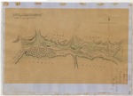
Download National Archives Diseño 49, #2 – Sespe (also called San Cayetano), GLO 397 (964 KB)
Download WPA Abstract – Sespe (also called San Cayetano), GLO 397 (1.7 MB)
Download Bancroft Notes – Sespe (also called San Cayetano), GLO 397 (44 KB)
Download BLM Patent, Mar. 14, 1872 – Sespe (also called San Cayetano), GLO 397 (10.1 MB)
Download BLM Land Patent Details – Sespe (also called San Cayetano), GLO 397 (110 KB)
Download BLM CDI Details – Sespe (also called San Cayetano), GLO 397 (242 KB)
Download BLM Survey, Nov. 24, 1874 – Sespe (also called San Cayetano), GLO 397 (11.3 MB)
Download BLM Survey, May 27, 1844 – Sespe (also called San Cayetano), GLO 397 (10.8 MB)
Subject
National Archives Diseños - Spanish/Mexican land grant map.
Work Progress Administration Abstract (WPA Abstract) – Historical details of a Spanish-Mexican land grant that was subsequently patented by the U. S. Government..
Bancroft Notes – Summary of Bancroft Archives information regarding a private land claim.
Bancroft Diseños -- Spanish/Mexican land grant map.
BLM Land Patent – U.S. Government issued document certifying a Private Land Claim.
BLM Land Patent Detail Sheet – BLM Accession number document that provides patent information.
BLM CDI Detail Sheet – CDI Doc ID document that provides patent information.
BLM Survey – Office of the U.S. Surveyor General plat(s) detailing the specific boundaries of land.
Description
National Archives Diseños - Hand-drawn Spanish-Mexican map demonstrating the physical boundaries of land granted to Mexican citizens by the Spanish or Mexican.
Work Progress Administration Abstract (WPA Abstract) – A summary document prepared in 1938 under the U. S. Work Progress Administration program detailing the history of a rancho beginning with the Spanish-American land through the U.S. patenting process.
Bancroft Notes – Document detailing information and documents regarding a rancho found in the Bancroft Archives.
Bancroft Diseños – Hand-drawn Spanish-Mexican map demonstrating the physical boundaries of land granted to Mexican citizens by the Spanish or Mexican governments used in the U.S. District Court proceedings.
BLM Land Patent – Hand-written document issued by the U.S. Government providing legal ownership of land previously granted by the Spanish or Mexican government.
BLM Land Patent Detail Sheet – Document using the BLM accession number that provides specific information regarding the patented land of a rancho.
BLM CDI Detail Sheet - Document using the CDI Doc ID that provides specific information concerning the patented land of a rancho.
BLM Survey(s) – Plat(s) prepared by the Office of the U.S. Surveyor General detailing the boundaries of the rancho.
Source
National Archives Diseño – U.S. National Archives; WPA Abstract - David Hornbeck, Ph.D.; Bancroft documents - Bancroft Archives; BLM documents – U.S. Bureau of Land Management
Format
Language
Spanish; English
Disciplines
Arts and Humanities | Education | Law | Life Sciences | Social and Behavioral Sciences
Original Format
Paper
Document Type
Map
Recommended Citation
"Sespe (also called San Cayetano), Diseño 49, GLO No. 397, Ventura (formerly Santa Barbara) County, and associated historical documents." (2018). Santa Barbara County. 51.
https://digitalcommons.csumb.edu/hornbeck_usa_4_a_sabc/51
Included in
Arts and Humanities Commons, Education Commons, Law Commons, Life Sciences Commons, Social and Behavioral Sciences Commons