
-
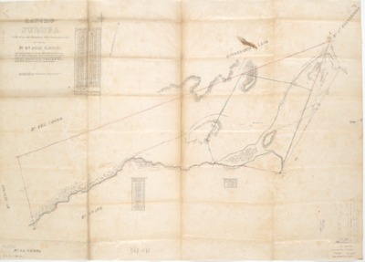
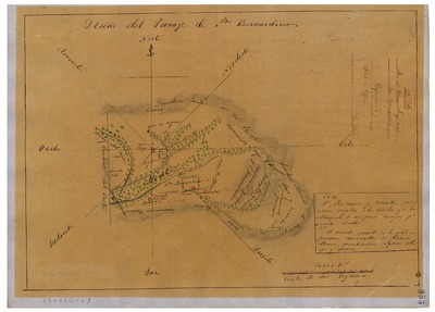
, Diseño 364, GLO No. 456, San Bernardino County, and associated historical documents.")
Azusa (Dalton), Diseño 364, GLO No. 456, San Bernardino County, and associated historical documents.
Diseños - Hand-drawn Spanish-Mexican map demonstrating the physical boundaries of land granted to Mexican citizens by the Spanish or Mexican.
Work Progress Administration Abstract (WPA Abstract) – A summary document prepared in 1938 under the Work Progress Administration program detailing the history of a rancho beginning with the Spanish-American land through the U.S. patenting process.
-
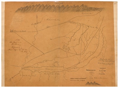
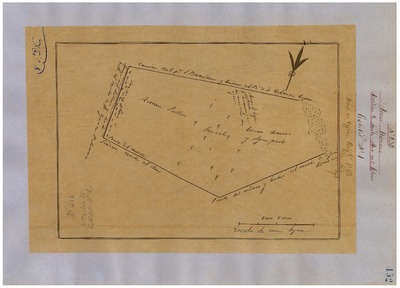
, San Bernardino County, Diseños 387, GLO No. 475, and associated historical documents.")
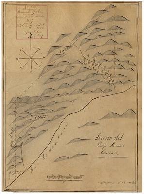
Cañon de Santa Ana (Cañada de Santa Ana), San Bernardino County, Diseños 387, GLO No. 475, and associated historical documents.
Diseños - Hand-drawn Spanish-Mexican map demonstrating the physical boundaries of land granted to Mexican citizens by the Spanish or Mexican.
Work Progress Administration Abstract (WPA Abstract) – A summary document prepared in 1938 under the Work Progress Administration program detailing the history of a rancho beginning with the Spanish-American land through the U.S. patenting process.
-

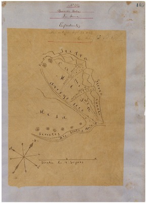
Cucamonga, Diseño 370, GLO No. 479, San Bernardino County, and associated historical documents.
Diseños - Hand-drawn Spanish-Mexican map demonstrating the physical boundaries of land granted to Mexican citizens by the Spanish or Mexican.
Work Progress Administration Abstract (WPA Abstract) – A summary document prepared in 1938 under the Work Progress Administration program detailing the history of a rancho beginning with the Spanish-American land through the U.S. patenting process.
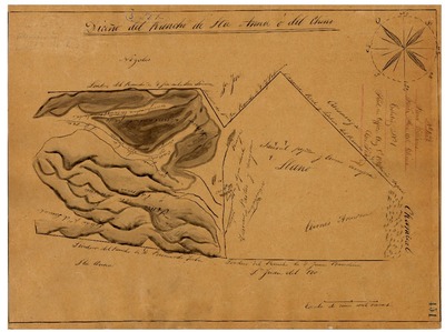
-
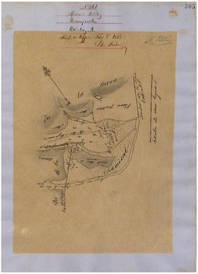
![El Rincón [Yorba], Diseño 384, GLO No. 476, San Bernardino County, and associated historical documents.](https://digitalcommons.csumb.edu/hornbeck_usa_4_a_snbc/1003/thumbnail.jpg "El Rincón [Yorba], Diseño 384, GLO No. 476, San Bernardino County, and associated historical documents.")
El Rincón [Yorba], Diseño 384, GLO No. 476, San Bernardino County, and associated historical documents.
Diseños - Hand-drawn Spanish-Mexican map demonstrating the physical boundaries of land granted to Mexican citizens by the Spanish or Mexican.
Work Progress Administration Abstract (WPA Abstract) – A summary document prepared in 1938 under the Work Progress Administration program detailing the history of a rancho beginning with the Spanish-American land through the U.S. patenting process.
-
, Diseño 463, GLO No. 482, San Bernardino County, and associated historical documents.")
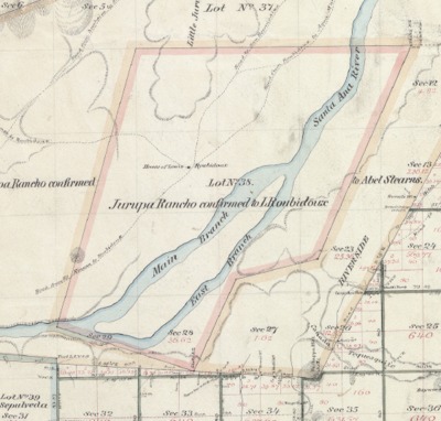
Jurupa (Rubidoux), Diseño 463, GLO No. 482, San Bernardino County, and associated historical documents.
Work Progress Administration Abstract (WPA Abstract) – A summary document prepared in 1938 under the U.S. Work Progress Administration program detailing the history of a rancho beginning with the Spanish-American land through the U.S. patenting process.
Bancroft Notes – Document detailing information and documents regarding a rancho found in the Bancroft Archives.
BLM Land Grant Patent – Hand-written document issued by the U.S. Government providing legal ownership of land previously granted by the Spanish or Mexican government.
BLM Land Patent Detail Sheet – Document using the BLM accession number that provides specific information regarding the patented land of a rancho.
BLM CDI Detail Sheet - Document using the CDI Doc ID that provides specific information concerning the patented land of a rancho.
BLM Survey(s) – Plat(s) prepared by the Office of the U.S. Surveyor General detailing the boundaries of the rancho.
WPA Abstract – David Hornbeck, Ph.D.; Bancroft documents – Bancroft Archives; BLM documents – Bureau of Land Management; Table of Land Claims – Ogden Hoffman.
-
, Diseño 361, GLO No. 483, San Bernardino County, and associated historical documents.")
Jurupa (Stearns), Diseño 361, GLO No. 483, San Bernardino County, and associated historical documents.
Bancroft Diseños – Hand-drawn Spanish-Mexican map demonstrating the physical boundaries of land granted to Mexican citizens by the Spanish or Mexican governments used in the U.S. District Court proceedings.
Work Progress Administration Abstract (WPA Abstract) – A summary document prepared in 1938 under the U.S. Work Progress Administration program detailing the history of a rancho beginning with the Spanish-American land through the U.S. patenting process.
Bancroft Notes – Document detailing information and documents regarding a rancho found in the Bancroft Archives.
BLM Land Grant Patent – Hand-written document issued by the U.S. Government providing legal ownership of land previously granted by the Spanish or Mexican government.
BLM Land Patent Detail Sheet – Document using the BLM accession number that provides specific information regarding the patented land of a rancho.
BLM CDI Detail Sheet - Document using the CDI Doc ID that provides specific information concerning the patented land of a rancho.
BLM Survey(s) – Plat(s) prepared by the Office of the U.S. Surveyor General detailing the boundaries of the rancho.
-

La Puente, Diseño 385 GLO No. 460, San Bernardino County, and associated historical documents.
Diseños - Hand-drawn Spanish-Mexican map demonstrating the physical boundaries of land granted to Mexican citizens by the Spanish or Mexican.
Work Progress Administration Abstract (WPA Abstract) – A summary document prepared in 1938 under the Work Progress Administration program detailing the history of a rancho beginning with the Spanish-American land through the U.S. patenting process.
-
, Diseño 382, GLO No. 485, San Bernardino County, and associated historical documents.")
La Sierra (Yorba), Diseño 382, GLO No. 485, San Bernardino County, and associated historical documents.
Diseños - Hand-drawn Spanish-Mexican map demonstrating the physical boundaries of land granted to Mexican citizens by the Spanish or Mexican.
Work Progress Administration Abstract (WPA Abstract) – A summary document prepared in 1938 under the Work Progress Administration program detailing the history of a rancho beginning with the Spanish-American land through the U.S. patenting process.
-

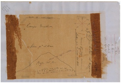
Los Nogales, Diseño 383, GLO No. 459, San Bernardino County, and associated historical documents.
Diseños - Hand-drawn Spanish-Mexican map demonstrating the physical boundaries of land granted to Mexican citizens by the Spanish or Mexican.
Work Progress Administration Abstract (WPA Abstract) – A summary document prepared in 1938 under the Work Progress Administration program detailing the history of a rancho beginning with the Spanish-American land through the U.S. patenting process.
-

Muscupiabe, Diseño 561, GLO No. 480, San Bernardino County, and associated historical documents.
Diseños - Hand-drawn Spanish-Mexican map demonstrating the physical boundaries of land granted to Mexican citizens by the Spanish or Mexican.
Work Progress Administration Abstract (WPA Abstract) – A summary document prepared in 1938 under the Work Progress Administration program detailing the history of a rancho beginning with the Spanish-American land through the U.S. patenting process.
-

Potreros of San Juan Capistrano, Diseño 394, GLO No. 494, San Bernardino County, and associated historical documents.
Diseños - Hand-drawn Spanish-Mexican map demonstrating the physical boundaries of land granted to Mexican citizens by the Spanish or Mexican.
Work Progress Administration Abstract (WPA Abstract) – A summary document prepared in 1938 under the Work Progress Administration program detailing the history of a rancho beginning with the Spanish-American land through the U.S. patenting process.
-
, Diseño 316, GLO No. 481, San Bernardino County, and associated historical documents.Diseños - Spanish/Mexican land grant map. Work Progress Administration Abstract (WPA Abstract) – Historical details of a Spanish-Mexican land grant that was subsequently patented by the U. S. Government.")
San Bernardino (Lugo), Diseño 316, GLO No. 481, San Bernardino County, and associated historical documents.Diseños - Spanish/Mexican land grant map. Work Progress Administration Abstract (WPA Abstract) – Historical details of a Spanish-Mexican land grant that was subsequently patented by the U. S. Government.
Diseños - Hand-drawn Spanish-Mexican map demonstrating the physical boundaries of land granted to Mexican citizens by the Spanish or Mexican.
Work Progress Administration Abstract (WPA Abstract) – A summary document prepared in 1938 under the Work Progress Administration program detailing the history of a rancho beginning with the Spanish-American land through the U.S. patenting process.
-

Santa Ana del Chino, Addition to, Diseño 434, GLO No. 478, San Bernardino County, and associated historical documents.
Diseños - Hand-drawn Spanish-Mexican map demonstrating the physical boundaries of land granted to Mexican citizens by the Spanish or Mexican.
Work Progress Administration Abstract (WPA Abstract) – A summary document prepared in 1938 under the Work Progress Administration program detailing the history of a rancho beginning with the Spanish-American land through the U.S. patenting process.
-

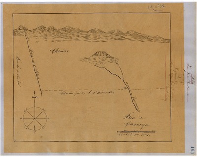
Santa Ana del Chino, Diseño 433, GLO No. 477, San Bernardino County, and associated historical documents.
Diseños - Hand-drawn Spanish-Mexican map demonstrating the physical boundaries of land granted to Mexican citizens by the Spanish or Mexican.
Work Progress Administration Abstract (WPA Abstract) – A summary document prepared in 1938 under the Work Progress Administration program detailing the history of a rancho beginning with the Spanish-American land through the U.S. patenting process.
Printing is not supported at the primary Gallery Thumbnail page. Please first navigate to a specific Image before printing.
