

Files
Download Full Text (779 KB)
Download WPA Abstract, Jurupa (Rubidoux), GLO 482 (1.8 MB)
Download Bancroft Notes, Jurupa (Rubidoux), GLO 482 (25 KB)
Download BLM Patent, Dec. 8, 1876, Jurupa (Rubidoux), GLO 482 (6.1 MB)
Download BLM Land Patent Details, Jurupa (Rubidoux), GLO 482 (109 KB)
Download BLM CDI Details, Jurupa (Rubidoux), GLO 482 (230 KB)
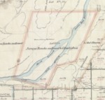
Download BLM Survey June 26, 1878, Jurupa (Rubidoux), GLO 482 (9.1 MB)
Download BLM Survey, Apr. 14, 1896, Jurupa (Rubidoux), GLO 482 (8.9 MB)
Subject
Work Progress Administration Abstract (WPA Abstract) – Historical details of a Spanish-Mexican land grant that was subsequently patented by the U. S. Government.
Bancroft Notes – Summary of Bancroft Archives information regarding a private land claim.
BLM Land Grant Patent – U.S. Government issued document certifying a Private Land Claim.
BLM Land Patent Detail Sheet – BLM Accession number document that provides patent information.
BLM CDI Detail Sheet – CDI Doc ID document that provides patent information.
BLM Survey – Office of the U.S. Surveyor General plat(s) detailing the specific boundaries of land.
Description
Work Progress Administration Abstract (WPA Abstract) – A summary document prepared in 1938 under the U.S. Work Progress Administration program detailing the history of a rancho beginning with the Spanish-American land through the U.S. patenting process.
Bancroft Notes – Document detailing information and documents regarding a rancho found in the Bancroft Archives.
BLM Land Grant Patent – Hand-written document issued by the U.S. Government providing legal ownership of land previously granted by the Spanish or Mexican government.
BLM Land Patent Detail Sheet – Document using the BLM accession number that provides specific information regarding the patented land of a rancho.
BLM CDI Detail Sheet - Document using the CDI Doc ID that provides specific information concerning the patented land of a rancho.
BLM Survey(s) – Plat(s) prepared by the Office of the U.S. Surveyor General detailing the boundaries of the rancho.
WPA Abstract – David Hornbeck, Ph.D.; Bancroft documents – Bancroft Archives; BLM documents – Bureau of Land Management; Table of Land Claims – Ogden Hoffman.
Source
WPA Abstract – David Hornbeck, Ph.D.; Bancroft documents – Bancroft Archives; BLM documents – Bureau of Land Management; Table of Land Claims – Ogden Hoffman.
Format
Language
Spanish, English
Disciplines
Arts and Humanities | Education | Law | Life Sciences | Social and Behavioral Sciences
Original Format
Paper
Document Type
Book
Recommended Citation
"Jurupa (Rubidoux), Diseño 463, GLO No. 482, San Bernardino County, and associated historical documents." (2018). San Bernardino County. 6.
https://digitalcommons.csumb.edu/hornbeck_usa_4_a_snbc/6