

Files
Download Full Text (17.3 MB)
Subject
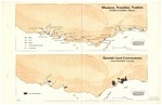
Conceptual maps reflecting California missions, presidios, pueblos, Spanish land concessions, Mexican land grants, patented ranchos, lands granted to Anglo Surnames, major hide and tallow collection points, and mission population.
Description
Conceptual maps from the 1983 publication, California Patterns: A Geographical and Historical Atlas by David Hornbeck in collaboration with cartographer, David Fuller, depicting California missions, presidios, pueblos, Spanish land concessions, Mexican land grants, patented ranchos, lands granted to Anglo Surnames, major hide and tallow collection points, and mission population. The maps cover periods from 1769 (Spanish and Mexican era) through the American patenting process up to 1885.
Source
David Hornbeck, Ph.D.
Format
Language
English
Disciplines
Arts and Humanities | Education | Law | Life Sciences | Social and Behavioral Sciences
Original Format
Paper
Document Type
Map
Recommended Citation
"1769-1885 - Conceptual California Maps, David Hornbeck and David Fuller" (2018). Overview of California Private Land Claims and the Public Domain. 2.
https://digitalcommons.csumb.edu/hornbeck_usa_4_b/2
Included in
Arts and Humanities Commons, Education Commons, Law Commons, Life Sciences Commons, Social and Behavioral Sciences Commons