

Files
Download Full Text (2.7 MB)
Subject
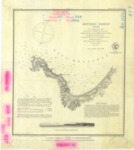
1882 - nautical map of the Monterey Harbour.
Description
The 1882 survey of Monterey Harbor, corrected the Aids to Navigation found on the 1852 Monterey Harbor map and extends up and around Point Pinos. Wharfs shown on the 1852 survey are not found on this map. Buildings and landmarks are identical to the 1852 survey indicating that the map was created for navigational purposes and not to reflect development along the Bay.
Source
National Oceanic and Atmospheric Administration
Format
JPEG
Language
English
Disciplines
Arts and Humanities | Education | Law | Life Sciences | Social and Behavioral Sciences
Original Format
Paper
Document Type
Map
Recommended Citation
"1882 - Monterey Harbour, California" (2018). Groundwater Basin Maps. 39.
https://digitalcommons.csumb.edu/hornbeck_cgb_4/39