

Files
Download
Download Full Text (12.7 MB)
Subject
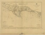
Topographical and navigational survey of San Luis Obispo Bay and Port Harford.
Description
The 1889 survey of San Luis Obispo Bay and Port Harford was based on surveys conducted as early as 1852. The map is focused on navigation of the bay listing the time and heights of the tides, latitude and longitude and location of bouys.
Source
National Oceanic and Atmospheric Administration
Format
JPEG
Language
English
Disciplines
Arts and Humanities | Education | Law | Life Sciences | Social and Behavioral Sciences
Original Format
Paper
Document Type
Map
Recommended Citation
"1889 - San Luis Obispo Bay and Port Harford" (2018). Groundwater Basin Maps. 40.
https://digitalcommons.csumb.edu/hornbeck_cgb_4/40