

Files
Download Full Text (463 KB)
Subject
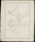
Early French map of the San Francisco Bay region, situated on the coast of Northern California.
Description
A 1797 map of the San Francisco Bay area ascribed to Jean Francois de Galaup, comte de Lapérouse. Lapérouse headed up a French expedition aimed at completing the Pacific discoveries of James Cook, correcting and complete maps of the region, establishing trade contacts, opening new maritime routes and enriching French science and scientific collections. He was to explore both the north and south Pacific, including costs of the Far East and Australia, and to send back reports through existing European outpost in the Pacific. Explorations began in 1785 with his last recorded landfall being in Australia in March 1788. In September 1786, Lapérouse stopped by the San Francisco Bay long enough to create an outline map of the region. This map was reproduced as Map 33 in L. Aubert’s 1787 Atlas du voyage de La Pérouse. The map identifies 21 place names that included Alcatraz, the Presidio of San Francisco, Point Reyes, the Mission de San Francisco and the Farallonne Islands. Lapérouse did not survey the region himself but most likely based his map on the maps of the area by earlier cartographers (1776-1785).
Source
Archivo Cartografico y de Estudios Geograficos, Madrid, Spain
Format
JPEG
Language
French
Disciplines
Arts and Humanities | Education | Social and Behavioral Sciences
Original Format
Paper
Document Type
Map
Recommended Citation
"1797 - Plan du Port de St. Francois, situe sur la cote de la Californie Septentrional" (2017). Pre-1824 Maps. 53.
https://digitalcommons.csumb.edu/hornbeck_spa_1_a/53