
Files
Download Full Text (613 KB)
Subject
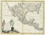
1785 Italian map depicting the region along the Rio Grande and what was then French Louisiana, Mexico and Central America.
Description
Early map published in Venice, Issued in Presso Antonio Zatta’s four volume atlas entitled Atlante Novissimo, depicts the Southern region of the United States, Mexico and Central America. It shows political divisions, cities, towns, coastal towns, mountains and rivers. Several indigenous tribes are noted in the plains, including, among others, the Kansez, Osages, Cheraquis, Cascaquas, Aacansas, Chicachas, Natchitoches, Tchatas, Choumas and Apacharia.
Source
Archivo Cartografico y de Estudios Geograficos, Madrid, Spain
Format
JPEG
Language
Italian
Disciplines
Arts and Humanities | Education | Social and Behavioral Sciences
Original Format
Paper
Document Type
Map
Recommended Citation
"1785 - Messico ovvero Nuova Spagna che contiene il Nuova Messico la California con una parte de’paesi adjacenti" (2017). Pre-1824 Maps. 29.
https://digitalcommons.csumb.edu/hornbeck_spa_1_a/29
