

Files
Subject
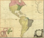
1786 map divided into the North and South America, West Indies that reflected the political boundaries along with a listing of United States and several European possessions.
Description
An early map that depicted both the North and South Americans along with the West Indies. It provides a glaring contrast between the known and unknown regions, with the Eastern parts of North America quite well understood, while the mythical River of the West was still shown as a continuous water course from the Atlantic to the Pacific. The map reflects the United States following the American Revolutionary War and included the addition of Spanish discoveries north of Baja California in what has been described as “fantastically detailed” topographical and geographical features. Included on this map is the often-disputed Chinese colony, Fou Sang, thought to have been settled c. 220 BC. The depiction of South America was largely based in part on the then recently published Juan de la Cruz Cano y Olmedilla’s 1775 map of South America, Mapa Geográfico De America Meridional.” The map includes an inset of northern Canada depicting the Hudson and Baffin Bays. It also includes a listing of United States and European political land holdings.
Source
Archivo General Militar de Madrid, Spain
Format
JPEG
Language
English
Disciplines
Arts and Humanities | Education | Social and Behavioral Sciences
Original Format
Paper
Document Type
Map
Recommended Citation
"1786 - A new map of the whole continent of America - divided into North and South and West Indies where they are exactly Described in United States of North America as well as the Several European Possessions according to the Preliminaries of Peace signed at Versailles, Jan 20, 1783" (2017). Pre-1824 Maps. 30.
https://digitalcommons.csumb.edu/hornbeck_spa_1_a/30