

Files
Download Full Text (4.4 MB)
Subject
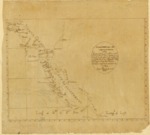
Early Mexican map depicting the two Californias following the initial Spanish occupation in 1769 that identified nine missions founded and presided over by Father Junipero Serra in Alta California, as well as four Presidios and the El Camino Real.
Description
Believed to be the earliest map to locate missions in Alta California, as well as El Camino Real –The King’s Highway—that connection the missions. The map also shows the four Presidios located at San Diego, Santa Barbara, Monterey and San Francisco. The map is thought to be the first map to depict the administrative borderline between the two Californias established by Francisco Palóu between the Franciscan and Dominican jurisdictions in 1774. Although there are some geographical inaccuracies, the map reflects islands, ports and rivers along the coastal region of California. A version of this map that included an ornate cartouche with a crown on top and the printed notation, Mar Pacifico, was included in the 1787 publication entitled, Relación histórica de la vida y apostólicas tareas del Venerable Padre Fray Junípero Serra, y de las misiones que fundó en la California septentrional, y nuevos establecimientos de Monterey.
Source
Archivo Cartografico y de Estudios Geograficos, Madrid, Spain
Format
JPEG
Language
Spanish
Disciplines
Arts and Humanities | Education | Social and Behavioral Sciences
Original Format
Paper
Document Type
Map
Recommended Citation
"1787 – Californias: Antigua y Nueva - Diego Troncoso Sc. Mexico" (2017). Pre-1824 Maps. 40.
https://digitalcommons.csumb.edu/hornbeck_spa_1_a/40