
Files
Download Full Text (719 KB)
Subject
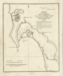
Early chart depicting the Port of San Diego.
Description
The chart of the Port of San Diego is based on a manuscript map made by Juan Pantoja y Arriaga during a seven-week exploration of the bay between August 21 and September 28, 1782. The chart was revised in 1786 with the addition of the Notes. It depicts the San Diego Bay and surrounding area, including the mission, presidio, ranches and soundings. It is thought to be the first reliable map of the bay. This map was Number 5 in the Atlas for the Voyage of the Subtle and Mexican Schooners to the Recognition of the Strait of Juan de Fuca in 1792, published in 1802. Not only did the language of the 1849 Guadalupe Hidalgo Treaty specifically incorporate the Pantoja Plan of the Port of San Diego into the treaty, a copy “signed and sealed by the respective plenipotentiaries” was annexed to the treaty. The first version of Pantoja map (without the added notes) was used by the Mexican and United States governments to establish the international boundary line south of the San Diego Bay. The precise location of the boundary between the two countries was marked in red ink on the Pantoja and signed by three Mexican representatives and the U.S. Commissioner, with an official seal affixed to it.
Source
Archivo Cartografico y de Estudios Geograficos, Madrid, Spain
Format
JPEG
Language
Spanish
Disciplines
Education | Social and Behavioral Sciences
Original Format
Paper
Document Type
Map
Recommended Citation
"1782 - Plano del Puerto de S. Diego" (2017). Pre-1824 Maps. 44.
https://digitalcommons.csumb.edu/hornbeck_spa_1_a/44
