

Files
Download Full Text (2.3 MB)
Subject
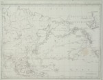
Early map of the Pacific Ocean showing regions from Central Asia to Baja California.
Description
A map depicting the northern regions of the Pacific Ocean by Jean Meares. The map reflects areas from Central Asia to Baja California but mainly focuses on the tracks of various explorers throughout the Northwest, Alaska, Canada, Hawaii, Western Pacific and Southeast Asia. The map traces routes taken by Captain James Cook in his third and final voyage between 1778 and 1779. The map also traces the courses taken in 1788 and 1789 by ships owned by British citizen, Captain Jean Meares who was perceived by some to be less than scrupulous in his words and deeds. Cook’s experience in the Pacific brought to light that there was an opportunity to make a fortune in the fur trade. This ultimately lead to legitimate and questionable fur trading by competing European interests, largely with the Chinese. Meares registered his ships in Macau, a Portuguese colony in China. The ships bore Portuguese names, “Iphigenia Nubiana” and “Felice Adventurero,” and were licensed under the Portuguese flag thus allowing Meares to circumvent the requirement that British traders be licensed by and pay duties to the East India Company. The fact that this is a French map suggests that it was most likely published in 1790 in a four volume French version of his English publication, “Voyages Made in the Years 1788 and 1789.” Meares included maps and plats in volume 4 of the French edition.
Source
Davidson Galleries, Seattle, Washington http://www.davidsongalleries.com
Format
JPEG
Language
French
Disciplines
Arts and Humanities | Education | Social and Behavioral Sciences
Original Format
Paper
Document Type
Map
Recommended Citation
"1790 – Carte de la Mer Pacifiquen, du Nord, contenant la Cote Nord-Est D’Aise et la Cote Nord-Ouest D’Amérique reconnues en 1778 et 79 par le Cap. Cook, et plus particulierement encore en 1788 et 89 par le Cap. Jean Meares" (2017). Pre-1824 Maps. 45.
https://digitalcommons.csumb.edu/hornbeck_spa_1_a/45