

-

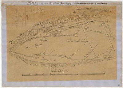
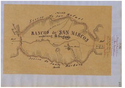
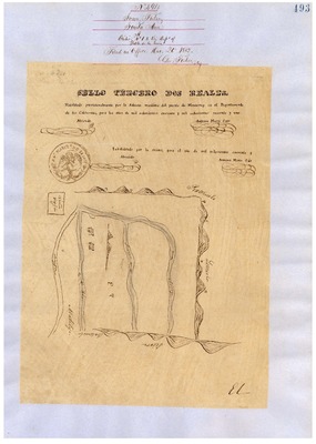
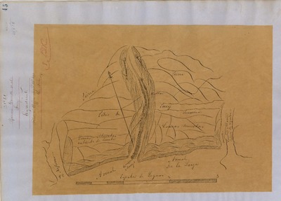
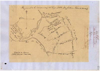
Cañada del Corral, Diseños 519, GLO 380, and associated historical documents
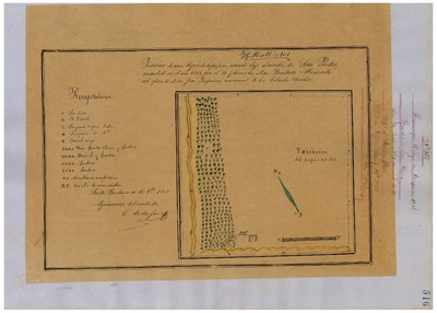
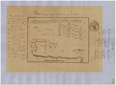
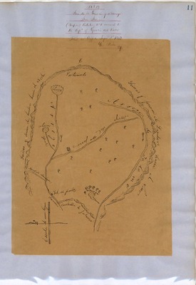
Diseños - Hand-drawn Spanish-Mexican map demonstrating the physical boundaries of land granted to Mexican citizens by the Spanish or Mexican.
Expediente – Hand-written Spanish-Mexican land grant document issued to Mexican citizens in Alta California for land in Alta-California.
Work Progress Administration Abstract (WPA Abstract) – A summary document prepared in 1938 under the Work Progress Administration program detailing the history of a rancho beginning with the Spanish-American land through the U.S. patenting process.
Hornbeck Rancho Detail Sheet – A summary sheet generated from a land patent database that details the history of a rancho, along with the various state and federal agency record numbers relating to the rancho.
Bancroft Notes – Document detailing information and documents regarding a particular rancho found in the Bancroft Archives.
Bancroft Diseños – Hand-drawn Spanish-Mexican map demonstrating the physical boundaries of land granted to Mexican citizens by the Spanish or Mexican governments used in the U.S. District Court proceedings.
Bancroft Plat – A plat of the patented rancho prepared by the U.S. Surveyor General.
BLM Land Grant Patent – Hand-written document issued by the U.S. Government providing legal ownership of land previously granted by the Spanish or Mexican government.
BLM Land Patent Detail Sheet – Document using the BLM accession number that provides specific information regarding the patented land of a rancho.
BLM CDI Detail Sheet - Document using the CDI Doc ID that provides specific information concerning the patented land of a rancho.
BLM Survey(s) – Plat(s) prepared by the Office of the U.S. Surveyor General detailing the boundaries of the rancho.
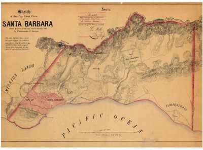
Santa Barbara County Recorded Land Grant Maps – Initial plat prepared by U.S. Surveyor General detailing the land grant the boundaries, township, range, course and distance.
-

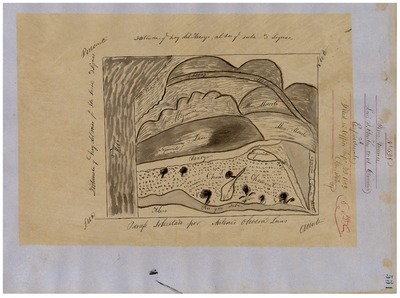
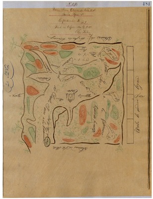
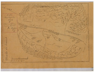
Cañada de Salsipuedes, Diseños 222, GLO 377, Santa Barbara County, and associated historical documents.
Diseños - Hand-drawn Spanish-Mexican map demonstrating the physical boundaries of land granted to Mexican citizens by the Spanish or Mexican.
Expediente – Hand-written Spanish-Mexican land grant document issued to Mexican citizens in Alta California for land in Alta-California.
Work Progress Administration Abstract (WPA Abstract) – A summary document prepared in 1938 under the Work Progress Administration program detailing the history of a rancho beginning with the Spanish-American land through the U.S. patenting process.
Hornbeck Rancho Detail Sheet – A summary sheet generated from a land patent database that details the history of a rancho, along with the various state and federal agency record numbers relating to the rancho.
Bancroft Notes – Document detailing information and documents regarding a particular rancho found in the Bancroft Archives.
Bancroft Diseños – Hand-drawn Spanish-Mexican map demonstrating the physical boundaries of land granted to Mexican citizens by the Spanish or Mexican governments used in the U.S. District Court proceedings.
Bancroft Plat – A plat of the patented rancho prepared by the U.S. Surveyor General.
BLM Land Grant Patent – Hand-written document issued by the U.S. Government providing legal ownership of land previously granted by the Spanish or Mexican government.
BLM Land Patent Detail Sheet – Document using the BLM accession number that provides specific information regarding the patented land of a rancho.
BLM CDI Detail Sheet - Document using the CDI Doc ID that provides specific information concerning the patented land of a rancho.
BLM Survey(s) – Plat(s) prepared by the Office of the U.S. Surveyor General detailing the boundaries of the rancho.
-

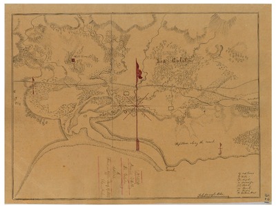
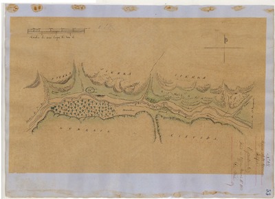
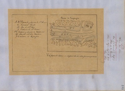
Casmalia, Diseños 553, GLO 355, Santa Barbara County, and associated documents
Diseños - Hand-drawn Spanish-Mexican map demonstrating the physical boundaries of land granted to Mexican citizens by the Spanish or Mexican.
Expediente – Hand-written Spanish-Mexican land grant document issued to Mexican citizens in Alta California for land in Alta-California.
Work Progress Administration Abstract (WPA Abstract) – A summary document prepared in 1938 under the Work Progress Administration program detailing the history of a rancho beginning with the Spanish-American land through the U.S. patenting process.
Hornbeck Rancho Detail Sheet – A summary sheet generated from a land patent database that details the history of a rancho, along with the various state and federal agency record numbers relating to the rancho.
Bancroft Notes – Document detailing information and documents regarding a particular rancho found in the Bancroft Archives.
Bancroft Diseños – Hand-drawn Spanish-Mexican map demonstrating the physical boundaries of land granted to Mexican citizens by the Spanish or Mexican governments used in the U.S. District Court proceedings.
Bancroft Plat – A plat of the patented rancho prepared by the U.S. Surveyor General.
BLM Land Grant Patent – Hand-written document issued by the U.S. Government providing legal ownership of land previously granted by the Spanish or Mexican government.
BLM Land Patent Detail Sheet – Document using the BLM accession number that provides specific information regarding the patented land of a rancho.
BLM CDI Detail Sheet - Document using the CDI Doc ID that provides specific information concerning the patented land of a rancho.
BLM Survey(s) – Plat(s) prepared by the Office of the U.S. Surveyor General detailing the boundaries of the rancho.
-

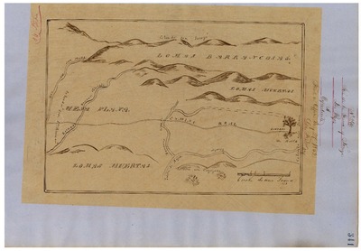
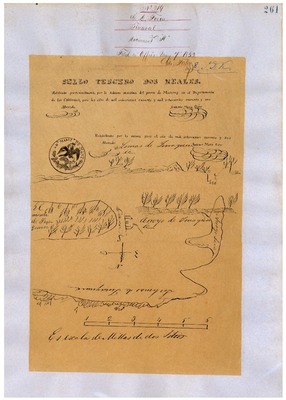
Corral de Quati, Diseños 189, GLO 362, Santa Barbara County, and associated documents
Diseños - Hand-drawn Spanish-Mexican map demonstrating the physical boundaries of land granted to Mexican citizens by the Spanish or Mexican.
Expediente – Hand-written Spanish-Mexican land grant document issued to Mexican citizens in Alta California for land in Alta-California.
Work Progress Administration Abstract (WPA Abstract) – A summary document prepared in 1938 under the Work Progress Administration program detailing the history of a rancho beginning with the Spanish-American land through the U.S. patenting process.
Hoffman Notes -- Summary of information concerning claims made for the Rancho lands from the Appendix listing Table of Land Claims in the Reports of Land Cases by Ogden Hoffman, Volume I, 1862.
Bancroft Notes – Document detailing information and documents regarding a particular rancho found in the Bancroft Archives.
Bancroft Diseños – Hand-drawn Spanish-Mexican map demonstrating the physical boundaries of land granted to Mexican citizens by the Spanish or Mexican governments used in the U.S. District Court proceedings.
Bancroft Plat – A plat of the patented rancho prepared by the U.S. Surveyor General.
BLM Land Grant Patent – Hand-written document issued by the U.S. Government providing legal ownership of land previously granted by the Spanish or Mexican government.
BLM Land Patent Detail Sheet – Document using the BLM accession number that provides specific information regarding the patented land of a rancho.
BLM CDI Detail Sheet - Document using the CDI Doc ID that provides specific information concerning the patented land of a rancho.
BLM Survey(s) – Plat(s) prepared by the Office of the U.S. Surveyor General detailing the boundaries of the rancho.
-

Cuyama No. 1, Diseños 67, GLO 341, Santa Barbara and San Luis Obispo Counties, and associated documents
Diseños - Hand-drawn Spanish-Mexican map demonstrating the physical boundaries of land granted to Mexican citizens by the Spanish or Mexican.
Expediente – Hand-written Spanish-Mexican land grant document issued to Mexican citizens in Alta California for land in Alta-California.
Work Progress Administration Abstract (WPA Abstract) – A summary document prepared in 1938 under the Work Progress Administration program detailing the history of a rancho beginning with the Spanish-American land through the U.S. patenting process.
Hornbeck Rancho Detail Sheet – A summary sheet generated from a land patent database that details the history of a rancho, along with the various state and federal agency record numbers relating to the rancho.
Bancroft Notes – Document detailing information and documents regarding a particular rancho found in the Bancroft Archives.
Bancroft Diseños – Hand-drawn Spanish-Mexican map demonstrating the physical boundaries of land granted to Mexican citizens by the Spanish or Mexican governments used in the U.S. District Court proceedings.
Bancroft Plat – A plat of the patented rancho prepared by the U.S. Surveyor General.
BLM Land Grant Patent – Hand-written document issued by the U.S. Government providing legal ownership of land previously granted by the Spanish or Mexican government.
BLM Land Patent Detail Sheet – Document using the BLM accession number that provides specific information regarding the patented land of a rancho.
BLM CDI Detail Sheet - Document using the CDI Doc ID that provides specific information concerning the patented land of a rancho.
BLM Survey(s) – Plat(s) prepared by the Office of the U.S. Surveyor General detailing the boundaries of the rancho.
-

Cuyama No. 2, Diseños 120, GLO 342, Santa Barbara and San Luis Obispo Counties, and associated documents
Diseños - Hand-drawn Spanish-Mexican map demonstrating the physical boundaries of land granted to Mexican citizens by the Spanish or Mexican.
Expediente – Hand-written Spanish-Mexican land grant document issued to Mexican citizens in Alta California for land in Alta-California.
Work Progress Administration Abstract (WPA Abstract) – A summary document prepared in 1938 under the Work Progress Administration program detailing the history of a rancho beginning with the Spanish-American land through the U.S. patenting process.
Hornbeck Rancho Detail Sheet – A summary sheet generated from a land patent database that details the history of a rancho, along with the various state and federal agency record numbers relating to the rancho.
Bancroft Notes – Document detailing information and documents regarding a particular rancho found in the Bancroft Archives.
Bancroft Diseños – Hand-drawn Spanish-Mexican map demonstrating the physical boundaries of land granted to Mexican citizens by the Spanish or Mexican governments used in the U.S. District Court proceedings.
Bancroft Plat – A plat of the patented rancho prepared by the U.S. Surveyor General.
BLM Land Grant Patent – Hand-written document issued by the U.S. Government providing legal ownership of land previously granted by the Spanish or Mexican government.
BLM Land Patent Detail Sheet – Document using the BLM accession number that provides specific information regarding the patented land of a rancho.
BLM CDI Detail Sheet - Document using the CDI Doc ID that provides specific information concerning the patented land of a rancho.
BLM Survey(s) – Plat(s) prepared by the Office of the U.S. Surveyor General detailing the boundaries of the rancho.
-
, Diseños 163, GLO 387, Santa Barbara and Ventura Counties, and associated documents")
El Rincón (Arellanes), Diseños 163, GLO 387, Santa Barbara and Ventura Counties, and associated documents
Diseños - Hand-drawn Spanish-Mexican map demonstrating the physical boundaries of land granted to Mexican citizens by the Spanish or Mexican.
Expediente – Hand-written Spanish-Mexican land grant document issued to Mexican citizens in Alta California for land in Alta-California.
Work Progress Administration Abstract (WPA Abstract) – A summary document prepared in 1938 under the Work Progress Administration program detailing the history of a rancho beginning with the Spanish-American land through the U.S. patenting process.
Hornbeck Rancho Detail Sheet – A summary sheet generated from a land patent database that details the history of a rancho, along with the various state and federal agency record numbers relating to the rancho.
Bancroft Notes – Document detailing information and documents regarding a particular rancho found in the Bancroft Archives.
Bancroft Diseños – Hand-drawn Spanish-Mexican map demonstrating the physical boundaries of land granted to Mexican citizens by the Spanish or Mexican governments used in the U.S. District Court proceedings.
Bancroft Plat – A plat of the patented rancho prepared by the U.S. Surveyor General.
BLM Land Grant Patent – Hand-written document issued by the U.S. Government providing legal ownership of land previously granted by the Spanish or Mexican government.
BLM Land Patent Detail Sheet – Document using the BLM accession number that provides specific information regarding the patented land of a rancho.
BLM CDI Detail Sheet - Document using the CDI Doc ID that provides specific information concerning the patented land of a rancho.
BLM Survey(s) – Plat(s) prepared by the Office of the U.S. Surveyor General detailing the boundaries of the rancho.
-
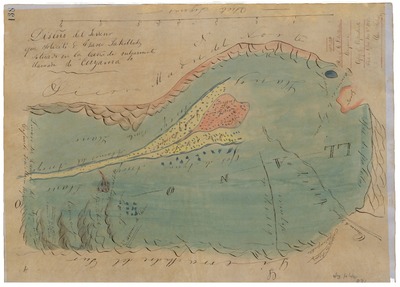
![Ex-Mission Santa Barbara, Lands of [Den], Diseños 621, Santa Barbara County, and associated historical documents](https://digitalcommons.csumb.edu/hornbeck_usa_4_a_sabc/1017/thumbnail.jpg "Ex-Mission Santa Barbara, Lands of [Den], Diseños 621, Santa Barbara County, and associated historical documents")
Ex-Mission Santa Barbara, Lands of [Den], Diseños 621, Santa Barbara County, and associated historical documents
Diseños - Hand-drawn Spanish-Mexican map demonstrating the physical boundaries of land granted to Mexican citizens by the Spanish or Mexican.
Expediente – Hand-written Spanish-Mexican land grant document issued to Mexican citizens in Alta California for land in Alta-California.
Work Progress Administration Abstract (WPA Abstract) – A summary document prepared in 1938 under the Work Progress Administration program detailing the history of a rancho beginning with the Spanish-American land through the U.S. patenting process.
Hoffman Notes -- Summary of information concerning claims made for the Rancho lands from the Appendix containing the Table of Land Claims in the Reports of Land Cases by Ogden Hoffman, Volume I, 1862.
Hoffman Table of Land Claims Appendix, Reports on Land Cases, Vol. I, 1862, p. 85, Ogden Hoffman; summary of information concerning claims made for the Rancho lands.
Hornbeck Rancho Detail Sheet – A summary sheet generated from a land patent database that details the history of a rancho, along with the various state and federal agency record numbers relating to the rancho.
Bancroft Notes – Document detailing information and documents regarding a particular rancho found in the Bancroft Archives.
Bancroft Diseños – Hand-drawn Spanish-Mexican map demonstrating the physical boundaries of land granted to Mexican citizens by the Spanish or Mexican governments used in the U.S. District Court proceedings.
Bancroft Plat – A plat of the patented rancho prepared by the U.S. Surveyor General.
BLM Land Grant Patent – Hand-written document issued by the U.S. Government providing legal ownership of land previously granted by the Spanish or Mexican government.
BLM Land Patent Detail Sheet – Document using the BLM accession number that provides specific information regarding the patented land of a rancho.
BLM CDI Detail Sheet - Document using the CDI Doc ID that provides specific information concerning the patented land of a rancho.
BLM Survey(s) – Plat(s) prepared by the Office of the U.S. Surveyor General detailing the boundaries of the rancho.
-
 County, and associated historical documents.")
Guadalasca, Diseño 31, GLO No. 406, Santa Barbara (Ventura) County, and associated historical documents.
National Archives Diseños - Hand-drawn Spanish-Mexican map demonstrating the physical boundaries of land granted to Mexican citizens by the Spanish or Mexican.
National Archives Expediente – Hand-written Spanish-Mexican land grant document issued to Spanish or Mexican citizens for land located in Alta-California.
Work Progress Administration Abstract (WPA Abstract) – A summary document prepared in 1938 under the U. S. Work Progress Administration program detailing the history of a rancho beginning with the Spanish-American land through the U.S. patenting process.
Bancroft Notes – Document detailing information and documents regarding a rancho found in the Bancroft Archives.
Bancroft Diseños – Hand-drawn Spanish-Mexican map demonstrating the physical boundaries of land granted to Mexican citizens by the Spanish or Mexican governments used in the U.S. District Court proceedings.
BLM Land Patent – Hand-written document issued by the U.S. Government providing legal ownership of land previously granted by the Spanish or Mexican government.
BLM Land Patent Detail Sheet – Document using the BLM accession number that provides specific information regarding the patented land of a rancho.
BLM CDI Detail Sheet - Document using the CDI Doc ID that provides specific information concerning the patented land of a rancho.
BLM Survey(s) – Plat(s) prepared by the Office of the U.S. Surveyor General detailing the boundaries of the rancho.
-

Guadalupe, Diseños 66, GLO 353, Santa Barbara and San Luis Obispo Counties, and associated documents
Diseños - Hand-drawn Spanish-Mexican map demonstrating the physical boundaries of land granted to Mexican citizens by the Spanish or Mexican.
Expediente – Hand-written Spanish-Mexican land grant document issued to Mexican citizens in Alta California for land in Alta-California.
Work Progress Administration Abstract (WPA Abstract) – A summary document prepared in 1938 under the Work Progress Administration program detailing the history of a rancho beginning with the Spanish-American land through the U.S. patenting process.
Hornbeck Rancho Detail Sheet – A summary sheet generated from a land patent database that details the history of a rancho, along with the various state and federal agency record numbers relating to the rancho.
Bancroft Notes – Document detailing information and documents regarding a particular rancho found in the Bancroft Archives.
Bancroft Diseños – Hand-drawn Spanish-Mexican map demonstrating the physical boundaries of land granted to Mexican citizens by the Spanish or Mexican governments used in the U.S. District Court proceedings.
Bancroft Plat – A plat of the patented rancho prepared by the U.S. Surveyor General.
BLM Land Grant Patent – Hand-written document issued by the U.S. Government providing legal ownership of land previously granted by the Spanish or Mexican government.
BLM Land Patent Detail Sheet – Document using the BLM accession number that provides specific information regarding the patented land of a rancho.
BLM CDI Detail Sheet - Document using the CDI Doc ID that provides specific information concerning the patented land of a rancho.
BLM Survey(s) – Plat(s) prepared by the Office of the U.S. Surveyor General detailing the boundaries of the rancho.
-

Island of Santa Cruz, Diseños 176, GLO 404, Santa Barbara County, and associated documents
Diseños - Hand-drawn Spanish-Mexican map demonstrating the physical boundaries of land granted to Mexican citizens by the Spanish or Mexican.
Expediente – Hand-written Spanish-Mexican land grant document issued to Mexican citizens in Alta California for land in Alta-California.
Work Progress Administration Abstract (WPA Abstract) – A summary document prepared in 1938 under the Work Progress Administration program detailing the history of a rancho beginning with the Spanish-American land through the U.S. patenting process.
Hornbeck Rancho Detail Sheet – A summary sheet generated from a land patent database that details the history of a rancho, along with the various state and federal agency record numbers relating to the rancho.
Bancroft Notes – Document detailing information and documents regarding a particular rancho found in the Bancroft Archives.
Bancroft Diseños – Hand-drawn Spanish-Mexican map demonstrating the physical boundaries of land granted to Mexican citizens by the Spanish or Mexican governments used in the U.S. District Court proceedings.
Bancroft Plat – A plat of the patented rancho prepared by the U.S. Surveyor General.
BLM Land Grant Patent – Hand-written document issued by the U.S. Government providing legal ownership of land previously granted by the Spanish or Mexican government.
BLM Land Patent Detail Sheet – Document using the BLM accession number that provides specific information regarding the patented land of a rancho.
BLM CDI Detail Sheet - Document using the CDI Doc ID that provides specific information concerning the patented land of a rancho.
BLM Survey(s) – Plat(s) prepared by the Office of the U.S. Surveyor General detailing the boundaries of the rancho.
-

Island of Santa Rosa, Diseños 117, GLO 405, Santa Barbara County, and associated documents
Diseños - Hand-drawn Spanish-Mexican map demonstrating the physical boundaries of land granted to Mexican citizens by the Spanish or Mexican.
Expediente – Hand-written Spanish-Mexican land grant document issued to Mexican citizens in Alta California for land in Alta-California.
Work Progress Administration Abstract (WPA Abstract) – A summary document prepared in 1938 under the Work Progress Administration program detailing the history of a rancho beginning with the Spanish-American land through the U.S. patenting process..
Hornbeck Rancho Detail Sheet – A summary sheet generated from a land patent database that details the history of a rancho, along with the various state and federal agency record numbers relating to the rancho.
Bancroft Notes – Document detailing information and documents regarding a particular rancho found in the Bancroft Archives.
Bancroft Diseños – Hand-drawn Spanish-Mexican map demonstrating the physical boundaries of land granted to Mexican citizens by the Spanish or Mexican governments used in the U.S. District Court proceedings.
Bancroft Plat – A plat of the patented rancho prepared by the U.S. Surveyor General.
BLM Land Grant Patent – Hand-written document issued by the U.S. Government providing legal ownership of land previously granted by the Spanish or Mexican government.
BLM Land Patent Detail Sheet – Document using the BLM accession number that provides specific information regarding the patented land of a rancho.
BLM CDI Detail Sheet - Document using the CDI Doc ID that provides specific information concerning the patented land of a rancho.
BLM Survey(s) – Plat(s) prepared by the Office of the U.S. Surveyor General detailing the boundaries of the rancho.
-

Jesús Maria, Diseños 528, GLO 356, Santa Barbara County, and associated documents.
Diseños - Hand-drawn Spanish-Mexican map demonstrating the physical boundaries of land granted to Mexican citizens by the Spanish or Mexican.
Expediente – Hand-written Spanish-Mexican land grant document issued to Mexican citizens in Alta California for land in Alta-California.
Work Progress Administration Abstract (WPA Abstract) – A summary document prepared in 1938 under the Work Progress Administration program detailing the history of a rancho beginning with the Spanish-American land through the U.S. patenting process.
Hornbeck Rancho Detail Sheet – A summary sheet generated from a land patent database that details the history of a rancho, along with the various state and federal agency record numbers relating to the rancho.
Bancroft Notes – Document detailing information and documents regarding a particular rancho found in the Bancroft Archives.
Bancroft Diseños – Hand-drawn Spanish-Mexican map demonstrating the physical boundaries of land granted to Mexican citizens by the Spanish or Mexican governments used in the U.S. District Court proceedings.
Bancroft Plat – A plat of the patented rancho prepared by the U.S. Surveyor General.
BLM Land Grant Patent – Hand-written document issued by the U.S. Government providing legal ownership of land previously granted by the Spanish or Mexican government.
BLM Land Patent Detail Sheet – Document using the BLM accession number that provides specific information regarding the patented land of a rancho.
BLM CDI Detail Sheet - Document using the CDI Doc ID that provides specific information concerning the patented land of a rancho.
BLM Survey(s) – Plat(s) prepared by the Office of the U.S. Surveyor General detailing the boundaries of the rancho.
-

La Goleta, Diseños 382, Santa Barbara County, and associated historical documents
Diseños - Hand-drawn Spanish-Mexican map demonstrating the physical boundaries of land granted to Mexican citizens by the Spanish or Mexican.
Expediente – Hand-written Spanish-Mexican land grant document issued to Mexican citizens in Alta California for land in Alta-California.
Work Progress Administration Abstract (WPA Abstract) – A summary document prepared in 1938 under the Work Progress Administration program detailing the history of a rancho beginning with the Spanish-American land through the U.S. patenting process.
Hoffman Notes -- Summary of information concerning claims made for the Rancho lands from the Appendix containing the Table of Land Claims in the Reports of Land Cases by Ogden Hoffman, Volume I, 1862.
Hoffman Table of Land Claims Appendix, Reports on Land Cases, Vol. I, 1862, p. 83 Ogden Hoffman; summary of information concerning claims made for the Rancho lands.
Hornbeck Rancho Detail Sheet – A summary sheet generated from a land patent database that details the history of a rancho, along with the various state and federal agency record numbers relating to the rancho.
Bancroft Notes – Document detailing information and documents regarding a particular rancho found in the Bancroft Archives.
Bancroft Diseños – Hand-drawn Spanish-Mexican map demonstrating the physical boundaries of land granted to Mexican citizens by the Spanish or Mexican governments used in the U.S. District Court proceedings.
Bancroft Plat – A plat of the patented rancho prepared by the U.S. Surveyor General.
BLM Land Grant Patent – Hand-written document issued by the U.S. Government providing legal ownership of land previously granted by the Spanish or Mexican government.
BLM Land Patent Detail Sheet – Document using the BLM accession number that provides specific information regarding the patented land of a rancho.
BLM CDI Detail Sheet - Document using the CDI Doc ID that provides specific information concerning the patented land of a rancho.
BLM Survey(s) – Plat(s) prepared by the Office of the U.S. Surveyor General detailing the boundaries of the rancho.
-
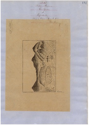
![La Laguna [Gutiérrez], Diseños 217, GLO 360, Santa Barbara County and associated historical documents](https://digitalcommons.csumb.edu/hornbeck_usa_4_a_sabc/1013/thumbnail.jpg "La Laguna [Gutiérrez], Diseños 217, GLO 360, Santa Barbara County and associated historical documents")
La Laguna [Gutiérrez], Diseños 217, GLO 360, Santa Barbara County and associated historical documents
Diseños - Hand-drawn Spanish-Mexican map demonstrating the physical boundaries of land granted to Mexican citizens by the Spanish or Mexican.
Expediente – Hand-written Spanish-Mexican land grant document issued to Mexican citizens in Alta California for land in Alta-California.
Work Progress Administration Abstract (WPA Abstract) – A summary document prepared in 1938 under the Work Progress Administration program detailing the history of a rancho beginning with the Spanish-American land through the U.S. patenting process.
Hoffman Notes -- Summary of information concerning claims made for the Rancho lands from the Appendix containing the Table of Land Claims in the Reports of Land Cases by Ogden Hoffman, Volume I, 1862.
Hoffman Table of Land Claims Appendix, Reports on Land Cases, Vol. I, 1862, p. 83, Ogden Hoffman; summary of information concerning claims made for the Rancho lands.
Hornbeck Rancho Detail Sheet – A summary sheet generated from a land patent database that details the history of a rancho, along with the various state and federal agency record numbers relating to the rancho.
Bancroft Notes – Document detailing information and documents regarding a particular rancho found in the Bancroft Archives.
Bancroft Diseños – Hand-drawn Spanish-Mexican map demonstrating the physical boundaries of land granted to Mexican citizens by the Spanish or Mexican governments used in the U.S. District Court proceedings.
Bancroft Plat/Map – A plat or map of the patented rancho prepared by the U.S. Surveyor General.
BLM Land Grant Patent – Hand-written document issued by the U.S. Government providing legal ownership of land previously granted by the Spanish or Mexican government.
BLM Land Patent Detail Sheet – Document using the BLM accession number that provides specific information regarding the patented land of a rancho.
BLM CDI Detail Sheet - Document using the CDI Doc ID that provides specific information concerning the patented land of a rancho.
BLM Survey(s) – Plat(s) prepared by the Office of the U.S. Surveyor General detailing the boundaries of the rancho.
-

La Misión Vieja de la Purísima, Diseños 178, GLO 376, Santa Barbara County, and associated historical documents
Diseños - Hand-drawn Spanish-Mexican map demonstrating the physical boundaries of land granted to Mexican citizens by the Spanish or Mexican.
Expediente – Hand-written Spanish-Mexican land grant document issued to Mexican citizens in Alta California for land in Alta-California.
Work Progress Administration Abstract (WPA Abstract) – A summary document prepared in 1938 under the Work Progress Administration program detailing the history of a rancho beginning with the Spanish-American land through the U.S. patenting process.
Hoffman Notes -- Summary of information concerning claims made for the Rancho lands from the Appendix containing the Table of Land Claims in the Reports of Land Cases by Ogden Hoffman, Volume I, 1862.
Hoffman Table of Land Claims Appendix, Reports on Land Cases, Vol. I, 1862, p. 83, Ogden Hoffman; summary of information concerning claims made for the Rancho lands.
Hornbeck Rancho Detail Sheet – A summary sheet generated from a land patent database that details the history of a rancho, along with the various state and federal agency record numbers relating to the rancho.
Bancroft Notes – Document detailing information and documents regarding a particular rancho found in the Bancroft Archives.
Bancroft Diseños – Hand-drawn Spanish-Mexican map demonstrating the physical boundaries of land granted to Mexican citizens by the Spanish or Mexican governments used in the U.S. District Court proceedings.
Bancroft Plat/Map – A plat or map of the patented rancho prepared by the U.S. Surveyor General.
BLM Land Grant Patent – Hand-written document issued by the U.S. Government providing legal ownership of land previously granted by the Spanish or Mexican government.
BLM Land Patent Detail Sheet – Document using the BLM accession number that provides specific information regarding the patented land of a rancho.
BLM CDI Detail Sheet - Document using the CDI Doc ID that provides specific information concerning the patented land of a rancho.
BLM Survey(s) – Plat(s) prepared by the Office of the U.S. Surveyor General detailing the boundaries of the rancho.
-

Las Posas, Diseños 296, GLO 401, Santa Barbara County, and associated historical documents
Diseños - Hand-drawn Spanish-Mexican map demonstrating the physical boundaries of land granted to Mexican citizens by the Spanish or Mexican.
Expediente – Hand-written Spanish-Mexican land grant document issued to Mexican citizens in Alta California for land in Alta-California.
Work Progress Administration Abstract (WPA Abstract) – A summary document prepared in 1938 under the Work Progress Administration program detailing the history of a rancho beginning with the Spanish-American land through the U.S. patenting process.
Hoffman Notes -- Summary of information concerning claims made for the Rancho lands from the Appendix containing the Table of Land Claims in the Reports of Land Cases by Ogden Hoffman, Volume I, 1862.
Hoffman Table of Land Claims Appendix, Reports on Land Cases, Vol. I, 1862, p. 83, Ogden Hoffman; summary of information concerning claims made for the Rancho lands.
Hornbeck Rancho Detail Sheet – A summary sheet generated from a land patent database that details the history of a rancho, along with the various state and federal agency record numbers relating to the rancho.
Bancroft Notes – Document detailing information and documents regarding a particular rancho found in the Bancroft Archives.
Bancroft Diseños – Hand-drawn Spanish-Mexican map demonstrating the physical boundaries of land granted to Mexican citizens by the Spanish or Mexican governments used in the U.S. District Court proceedings.
Bancroft Plat/Map – A plat or map of the patented rancho prepared by the U.S. Surveyor General.
BLM Land Grant Patent – Hand-written document issued by the U.S. Government providing legal ownership of land previously granted by the Spanish or Mexican government.
BLM Land Patent Detail Sheet – Document using the BLM accession number that provides specific information regarding the patented land of a rancho.
BLM CDI Detail Sheet - Document using the CDI Doc ID that provides specific information concerning the patented land of a rancho.
BLM Survey(s) – Plat(s) prepared by the Office of the U.S. Surveyor General detailing the boundaries of the rancho.
-

Las Positas y La Calera, GLO 385, Diseños 221, Santa Barbara County, and associated historical documents.
Diseños - Hand-drawn Spanish-Mexican map demonstrating the physical boundaries of land granted to Mexican citizens by the Spanish or Mexican.
Expediente – Hand-written Spanish-Mexican land grant document issued to Mexican citizens in Alta California for land in Alta-California.
Work Progress Administration Abstract (WPA Abstract) – A summary document prepared in 1938 under the Work Progress Administration program detailing the history of a rancho beginning with the Spanish-American land through the U.S. patenting process.
Hoffman Notes -- Summary of information concerning claims made for the Rancho lands from the Appendix containing the Table of Land Claims in the Reports of Land Cases by Ogden Hoffman, Volume I, 1862.
Hoffman Table of Land Claims Appendix, Reports on Land Cases, Vol. I, 1862, p. 83, Ogden Hoffman; summary of information concerning claims made for the Rancho lands.
Hornbeck Rancho Detail Sheet – A summary sheet generated from a land patent database that details the history of a rancho, along with the various state and federal agency record numbers relating to the rancho.
Bancroft Notes – Document detailing information and documents regarding a particular rancho found in the Bancroft Archives.
Bancroft Diseños – Hand-drawn Spanish-Mexican map demonstrating the physical boundaries of land granted to Mexican citizens by the Spanish or Mexican governments used in the U.S. District Court proceedings.
Bancroft Plat/Map – A plat or map of the patented rancho prepared by the U.S. Surveyor General.
BLM Land Grant Patent – Hand-written document issued by the U.S. Government providing legal ownership of land previously granted by the Spanish or Mexican government.
BLM Land Patent Detail Sheet – Document using the BLM accession number that provides specific information regarding the patented land of a rancho.
BLM CDI Detail Sheet - Document using the CDI Doc ID that provides specific information concerning the patented land of a rancho.
BLM Survey(s) – Plat(s) prepared by the Office of the U.S. Surveyor General detailing the boundaries of the rancho.
-

La Zaca, Diseños 265, GLO 361, Santa Barbara County, and associated historical documents.
Diseños - Hand-drawn Spanish-Mexican map demonstrating the physical boundaries of land granted to Mexican citizens by the Spanish or Mexican.
Expediente – Hand-written Spanish-Mexican land grant document issued to Mexican citizens in Alta California for land in Alta-California.
Work Progress Administration Abstract (WPA Abstract) – A summary document prepared in 1938 under the Work Progress Administration program detailing the history of a rancho beginning with the Spanish-American land through the U.S. patenting process.
Hoffman Notes -- Summary of information concerning claims made for the Rancho lands from the Appendix containing the Table of Land Claims in the Reports of Land Cases by Ogden Hoffman, Volume I, 1862.
Hoffman Table of Land Claims Appendix, Reports on Land Cases, Vol. I, 1862, p. 83, Ogden Hoffman; summary of information concerning claims made for the Rancho lands.
Hornbeck Rancho Detail Sheet – A summary sheet generated from a land patent database that details the history of a rancho, along with the various state and federal agency record numbers relating to the rancho.
Bancroft Notes – Document detailing information and documents regarding a particular rancho found in the Bancroft Archives.
Bancroft Diseños – Hand-drawn Spanish-Mexican map demonstrating the physical boundaries of land granted to Mexican citizens by the Spanish or Mexican governments used in the U.S. District Court proceedings.
Bancroft Plat/Map – A plat or map of the patented rancho prepared by the U.S. Surveyor General.
BLM Land Grant Patent – Hand-written document issued by the U.S. Government providing legal ownership of land previously granted by the Spanish or Mexican government.
BLM Land Patent Detail Sheet – Document using the BLM accession number that provides specific information regarding the patented land of a rancho.
BLM CDI Detail Sheet - Document using the CDI Doc ID that provides specific information concerning the patented land of a rancho.
BLM Survey(s) – Plat(s) prepared by the Office of the U.S. Surveyor General detailing the boundaries of the rancho.
-

Lomas de la Purificacion, Diseños 266, Santa Barbara County, and associated historical documents.
Diseños - Hand-drawn Spanish-Mexican map demonstrating the physical boundaries of land granted to Mexican citizens by the Spanish or Mexican.
Expediente – Hand-written Spanish-Mexican land grant document issued to Mexican citizens in Alta California for land in Alta-California.
Work Progress Administration Abstract (WPA Abstract) – A summary document prepared in 1938 under the Work Progress Administration program detailing the history of a rancho beginning with the Spanish-American land through the U.S. patenting process.
Hoffman Notes -- Summary of information concerning claims made for the Rancho lands from the Appendix containing the Table of Land Claims in the Reports of Land Cases by Ogden Hoffman, Volume I, 1862.
Hoffman Table of Land Claims Appendix, Reports on Land Cases, Vol. I, 1862, p. 83, Ogden Hoffman; summary of information concerning claims made for the Rancho lands.
Hornbeck Rancho Detail Sheet – A summary sheet generated from a land patent database that details the history of a rancho, along with the various state and federal agency record numbers relating to the rancho.
Bancroft Notes – Document detailing information and documents regarding a particular rancho found in the Bancroft Archives.
Bancroft Diseños – Hand-drawn Spanish-Mexican map demonstrating the physical boundaries of land granted to Mexican citizens by the Spanish or Mexican governments used in the U.S. District Court proceedings.
Bancroft Plat/Map – A plat or map of the patented rancho prepared by the U.S. Surveyor General.
BLM Land Grant Patent – Hand-written document issued by the U.S. Government providing legal ownership of land previously granted by the Spanish or Mexican government.
BLM Land Patent Detail Sheet – Document using the BLM accession number that provides specific information regarding the patented land of a rancho.
BLM CDI Detail Sheet - Document using the CDI Doc ID that provides specific information concerning the patented land of a rancho.
BLM Survey(s) – Plat(s) prepared by the Office of the U.S. Surveyor General detailing the boundaries of the rancho.
-

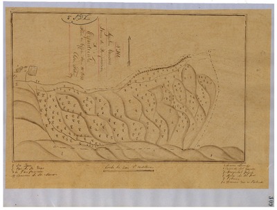
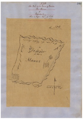
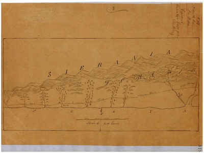
Los Alamos, Diseños 324, GLO 358, Santa Barbara County, and associated historical documents
Diseños - Hand-drawn Spanish-Mexican map demonstrating the physical boundaries of land granted to Mexican citizens by the Spanish or Mexican.
Expediente – Hand-written Spanish-Mexican land grant document issued to Mexican citizens in Alta California for land in Alta-California.
Work Progress Administration Abstract (WPA Abstract) – A summary document prepared in 1938 under the Work Progress Administration program detailing the history of a rancho beginning with the Spanish-American land through the U.S. patenting process.
Hoffman Notes -- Summary of information concerning claims made for the Rancho lands from the Appendix containing the Table of Land Claims in the Reports of Land Cases by Ogden Hoffman, Volume I, 1862.
Hoffman Table of Land Claims Appendix, Reports on Land Cases, Vol. I, 1862, p. 83, Ogden Hoffman; summary of information concerning claims made for the Rancho lands.
Hornbeck Rancho Detail Sheet – A summary sheet generated from a land patent database that details the history of a rancho, along with the various state and federal agency record numbers relating to the rancho.
Bancroft Notes – Document detailing information and documents regarding a particular rancho found in the Bancroft Archives.
Bancroft Diseños – Hand-drawn Spanish-Mexican map demonstrating the physical boundaries of land granted to Mexican citizens by the Spanish or Mexican governments used in the U.S. District Court proceedings.
Bancroft Plat/Map – A plat or map of the patented rancho prepared by the U.S. Surveyor General.
BLM Land Grant Patent – Hand-written document issued by the U.S. Government providing legal ownership of land previously granted by the Spanish or Mexican government.
BLM Land Patent Detail Sheet – Document using the BLM accession number that provides specific information regarding the patented land of a rancho.
BLM CDI Detail Sheet - Document using the CDI Doc ID that provides specific information concerning the patented land of a rancho.
BLM Survey(s) – Plat(s) prepared by the Office of the U.S. Surveyor General detailing the boundaries of the rancho.
-

Los Dos Pueblos, Diseños 517, GLO 381, Santa Barbara County, and associated historical documents
Diseños - Hand-drawn Spanish-Mexican map demonstrating the physical boundaries of land granted to Mexican citizens by the Spanish or Mexican.
Expediente – Hand-written Spanish-Mexican land grant document issued to Mexican citizens in Alta California for land in Alta-California.
Work Progress Administration Abstract (WPA Abstract) – A summary document prepared in 1938 under the Work Progress Administration program detailing the history of a rancho beginning with the Spanish-American land through the U.S. patenting process.
Hoffman Notes -- Summary of information concerning claims made for the Rancho lands from the Appendix containing the Table of Land Claims in the Reports of Land Cases by Ogden Hoffman, Volume I, 1862.
Hoffman Table of Land Claims Appendix, Reports on Land Cases, Vol. I, 1862, p. 83, Ogden Hoffman; summary of information concerning claims made for the Rancho lands.
Hornbeck Rancho Detail Sheet – A summary sheet generated from a land patent database that details the history of a rancho, along with the various state and federal agency record numbers relating to the rancho.
Bancroft Notes – Document detailing information and documents regarding a particular rancho found in the Bancroft Archives.
Bancroft Diseños – Hand-drawn Spanish-Mexican map demonstrating the physical boundaries of land granted to Mexican citizens by the Spanish or Mexican governments used in the U.S. District Court proceedings.
Bancroft Plat/Map – A plat or map of the patented rancho prepared by the U.S. Surveyor General.
BLM Land Grant Patent – Hand-written document issued by the U.S. Government providing legal ownership of land previously granted by the Spanish or Mexican government.
BLM Land Patent Detail Sheet – Document using the BLM accession number that provides specific information regarding the patented land of a rancho.
BLM CDI Detail Sheet - Document using the CDI Doc ID that provides specific information concerning the patented land of a rancho.
BLM Survey(s) – Plat(s) prepared by the Office of the U.S. Surveyor General detailing the boundaries of the rancho.
-
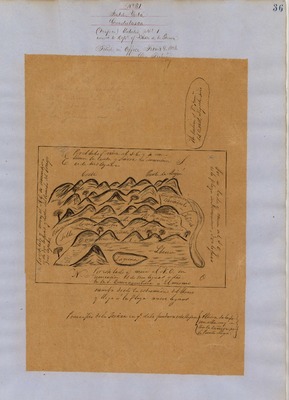
![Mission la Purísima [Malo], Diseños 476, GLO 372, Santa Barbara County, and associated documents](https://digitalcommons.csumb.edu/hornbeck_usa_4_a_sabc/1014/thumbnail.jpg "Mission la Purísima [Malo], Diseños 476, GLO 372, Santa Barbara County, and associated documents")
Mission la Purísima [Malo], Diseños 476, GLO 372, Santa Barbara County, and associated documents
Diseños - Hand-drawn Spanish-Mexican map demonstrating the physical boundaries of land granted to Mexican citizens by the Spanish or Mexican.
Expediente – Hand-written Spanish-Mexican land grant document issued to Mexican citizens in Alta California for land in Alta-California.
Work Progress Administration Abstract (WPA Abstract) – A summary document prepared in 1938 under the Work Progress Administration program detailing the history of a rancho beginning with the Spanish-American land through the U.S. patenting process.
Hoffman Notes -- Summary of information concerning claims made for the Rancho lands from the Appendix containing the Table of Land Claims in the Reports of Land Cases by Ogden Hoffman, Volume I, 1862.
Hoffman Table of Land Claims Appendix, Reports on Land Cases, Vol. I, 1862, p. 83 Ogden Hoffman; summary of information concerning claims made for the Rancho lands.
Hornbeck Rancho Detail Sheet – A summary sheet generated from a land patent database that details the history of a rancho, along with the various state and federal agency record numbers relating to the rancho.
Bancroft Notes – Document detailing information and documents regarding a particular rancho found in the Bancroft Archives.
Bancroft Diseños – Hand-drawn Spanish-Mexican map demonstrating the physical boundaries of land granted to Mexican citizens by the Spanish or Mexican governments used in the U.S. District Court proceedings.
Bancroft Plat – A plat of the patented rancho prepared by the U.S. Surveyor General.
BLM Land Grant Patent – Hand-written document issued by the U.S. Government providing legal ownership of land previously granted by the Spanish or Mexican government.
BLM Land Patent Detail Sheet – Document using the BLM accession number that provides specific information regarding the patented land of a rancho.
BLM CDI Detail Sheet - Document using the CDI Doc ID that provides specific information concerning the patented land of a rancho.
BLM Survey(s) – Plat(s) prepared by the Office of the U.S. Surveyor General detailing the boundaries of the rancho.
-
 County, and associated historical documents.")
Mission San Buenaventura, Lot in; Diseño 51, GLO No. 393, Ventura (formerly Santa Barbara) County, and associated historical documents.
Work Progress Administration Abstract (WPA Abstract) – A summary document prepared in 1938 under the U.S. Work Progress Administration program detailing the history of a rancho beginning with the Spanish-American land grant through the U.S. patenting process.
Bancroft Notes – Document detailing information and documents regarding a rancho found in the Bancroft Archives.
BLM Land Patent – Hand-written document issued by the U.S. Government providing legal ownership of land previously granted by the Spanish or Mexican government.
BLM Land Patent Detail Sheet – Document using the BLM accession number that provides specific information regarding the patented land of a rancho.
BLM CDI Detail Sheet - Document using the CDI Doc ID that provides specific information concerning the patented land of a rancho.
-
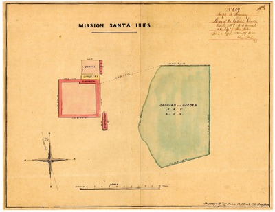
, Diseños 609, GLO 384, Santa Barbara County, and associated historical documents")
Mission Santa Bárbara, Lands of (Church property), Diseños 609, GLO 384, Santa Barbara County, and associated historical documents
Diseños - Hand-drawn Spanish-Mexican map demonstrating the physical boundaries of land granted to Mexican citizens by the Spanish or Mexican.
Expediente – Hand-written Spanish-Mexican land grant document issued to Mexican citizens in Alta California for land in Alta-California.
Work Progress Administration Abstract (WPA Abstract) – A summary document prepared in 1938 under the Work Progress Administration program detailing the history of a rancho beginning with the Spanish-American land through the U.S. patenting process.
Hoffman Notes -- Summary of information concerning claims made for the Rancho lands from the Appendix containing the Table of Land Claims in the Reports of Land Cases by Ogden Hoffman, Volume I, 1862.
Hoffman Table of Land Claims Appendix, Reports on Land Cases, Vol. I, 1862, p. 83 Ogden Hoffman; summary of information concerning claims made for the Rancho lands.
Hornbeck Rancho Detail Sheet – A summary sheet generated from a land patent database that details the history of a rancho, along with the various state and federal agency record numbers relating to the rancho.
Bancroft Notes – Document detailing information and documents regarding a particular rancho found in the Bancroft Archives.
Bancroft Diseños – Hand-drawn Spanish-Mexican map demonstrating the physical boundaries of land granted to Mexican citizens by the Spanish or Mexican governments used in the U.S. District Court proceedings.
Bancroft Plat – A plat of the patented rancho prepared by the U.S. Surveyor General.
BLM Land Grant Patent – Hand-written document issued by the U.S. Government providing legal ownership of land previously granted by the Spanish or Mexican government.
BLM Land Patent Detail Sheet – Document using the BLM accession number that provides specific information regarding the patented land of a rancho.
BLM CDI Detail Sheet - Document using the CDI Doc ID that provides specific information concerning the patented land of a rancho
BLM Survey(s) – Plat(s) prepared by the Office of the U.S. Surveyor General detailing the boundaries of the rancho.
Printing is not supported at the primary Gallery Thumbnail page. Please first navigate to a specific Image before printing.