

-

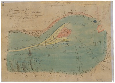
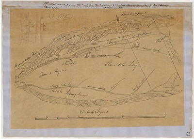
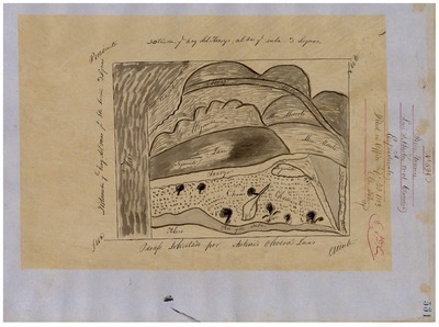
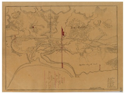
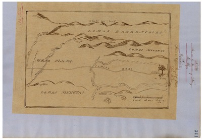
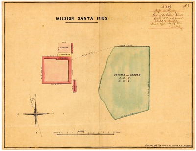
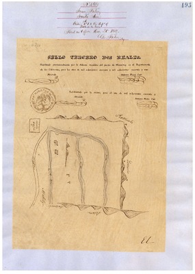
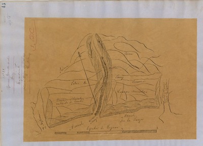
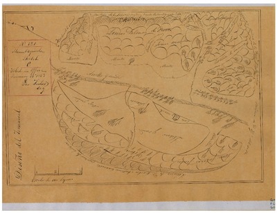
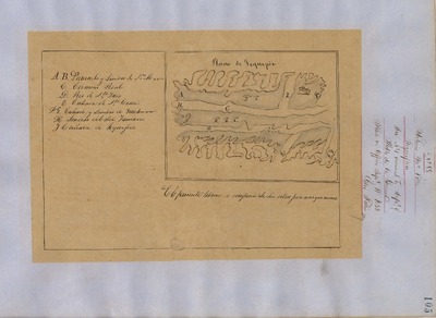
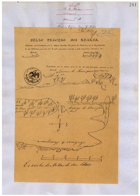
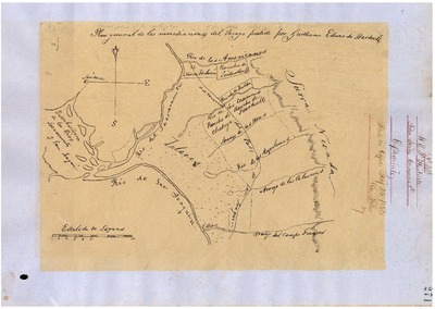
Mission Santa Ynéz or Inéz, Lands of; Diseños 609, GLO 368, Santa Barbara County, and associated documents
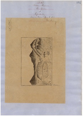
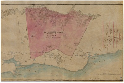
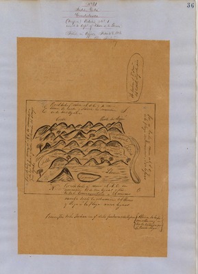
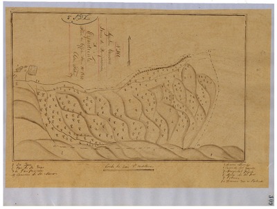
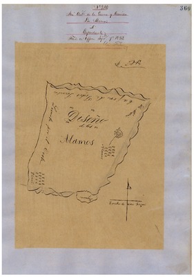
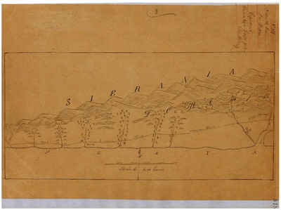
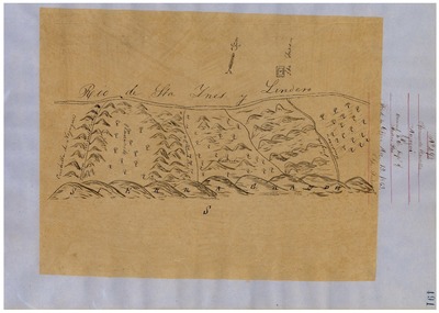
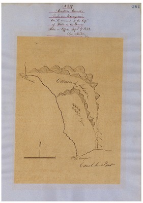
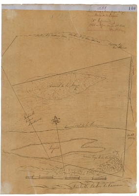
Diseños - Hand-drawn Spanish-Mexican map demonstrating the physical boundaries of land granted to Mexican citizens by the Spanish or Mexican.
Expediente – Hand-written Spanish-Mexican land grant document issued to Mexican citizens in Alta California for land in Alta-California.
Work Progress Administration Abstract (WPA Abstract) – A summary document prepared in 1938 under the Work Progress Administration program detailing the history of a rancho beginning with the Spanish-American land through the U.S. patenting process.
Hoffman Notes -- Summary of information concerning claims made for the Rancho lands from the Appendix containing the Table of Land Claims in the Reports of Land Cases by Ogden Hoffman, Volume I, 1862.
Hoffman Table of Land Claims Appendix, Reports on Land Cases, Vol. I, 1862, p. 83 Ogden Hoffman; summary of information concerning claims made for the Rancho lands.
Hornbeck Rancho Detail Sheet – A summary sheet generated from a land patent database that details the history of a rancho, along with the various state and federal agency record numbers relating to the rancho.
Bancroft Notes – Document detailing information and documents regarding a particular rancho found in the Bancroft Archives.
Bancroft Diseños – Hand-drawn Spanish-Mexican map demonstrating the physical boundaries of land granted to Mexican citizens by the Spanish or Mexican governments used in the U.S. District Court proceedings.
Bancroft Plat – A plat of the patented rancho prepared by the U.S. Surveyor General.
BLM Land Grant Patent – Hand-written document issued by the U.S. Government providing legal ownership of land previously granted by the Spanish or Mexican government.
BLM Land Patent Detail Sheet – Document using the BLM accession number that provides specific information regarding the patented land of a rancho.
BLM CDI Detail Sheet - Document using the CDI Doc ID that provides specific information concerning the patented land of a rancho.
BLM Survey(s) – Plat(s) prepared by the Office of the U.S. Surveyor General detailing the boundaries of the rancho.
-

Nipomo, Diseños 9, GLO 351, Santa Barbara and San Luis Obispo Counties, and associated historical documents
Diseños - Hand-drawn Spanish-Mexican map demonstrating the physical boundaries of land granted to Mexican citizens by the Spanish or Mexican.
Expediente – Hand-written Spanish-Mexican land grant document issued to Mexican citizens in Alta California for land in Alta-California.
Work Progress Administration Abstract (WPA Abstract) – A summary document prepared in 1938 under the Work Progress Administration program detailing the history of a rancho beginning with the Spanish-American land through the U.S. patenting process.
Hoffman Notes -- Summary of information concerning claims made for the Rancho lands from the Appendix containing the Table of Land Claims in the Reports of Land Cases by Ogden Hoffman, Volume I, 1862.
Hoffman Table of Land Claims Appendix, Reports on Land Cases, Vol. I, 1862, p. 2, Ogden Hoffman; summary of information concerning claims made for the Rancho lands.
Hornbeck Rancho Detail Sheet – A summary sheet generated from a land patent database that details the history of a rancho, along with the various state and federal agency record numbers relating to the rancho.
Bancroft Notes – Document detailing information and documents regarding a particular rancho found in the Bancroft Archives.
Bancroft Diseños – Hand-drawn Spanish-Mexican map demonstrating the physical boundaries of land granted to Mexican citizens by the Spanish or Mexican governments used in the U.S. District Court proceedings.
Bancroft Plat/Map – A plat or map of the patented rancho prepared by the U.S. Surveyor General.
BLM Land Grant Patent – Hand-written document issued by the U.S. Government providing legal ownership of land previously granted by the Spanish or Mexican government.
BLM Land Patent Detail Sheet – Document using the BLM accession number that provides specific information regarding the patented land of a rancho.
BLM CDI Detail Sheet - Document using the CDI Doc ID that provides specific information concerning the patented land of a rancho.
BLM Survey(s) – Plat(s) prepared by the Office of the U.S. Surveyor General detailing the boundaries of the rancho.
-

Nojoqui, Diseños 492, GLO 367, Santa Barbara County, and associated historical documents
Diseños - Hand-drawn Spanish-Mexican map demonstrating the physical boundaries of land granted to Mexican citizens by the Spanish or Mexican.
Expediente – Hand-written Spanish-Mexican land grant document issued to Mexican citizens in Alta California for land in Alta-California.
Work Progress Administration Abstract (WPA Abstract) – A summary document prepared in 1938 under the Work Progress Administration program detailing the history of a rancho beginning with the Spanish-American land through the U.S. patenting process.
Hoffman Notes -- Summary of information concerning claims made for the Rancho lands from the Appendix containing the Table of Land Claims in the Reports of Land Cases by Ogden Hoffman, Volume I, 1862.
Hoffman Table of Land Claims Appendix, Reports on Land Cases, Vol. I, 1862, p. 83, Ogden Hoffman; summary of information concerning claims made for the Rancho lands.
Hornbeck Rancho Detail Sheet – A summary sheet generated from a land patent database that details the history of a rancho, along with the various state and federal agency record numbers relating to the rancho.
Bancroft Notes – Document detailing information and documents regarding a particular rancho found in the Bancroft Archives.
Bancroft Diseños – Hand-drawn Spanish-Mexican map demonstrating the physical boundaries of land granted to Mexican citizens by the Spanish or Mexican governments used in the U.S. District Court proceedings.
Bancroft Plat/Map – A plat or map of the patented rancho prepared by the U.S. Surveyor General.
BLM Land Grant Patent – Hand-written document issued by the U.S. Government providing legal ownership of land previously granted by the Spanish or Mexican government.
BLM Land Patent Detail Sheet – Document using the BLM accession number that provides specific information regarding the patented land of a rancho.
BLM CDI Detail Sheet - Document using the CDI Doc ID that provides specific information concerning the patented land of a rancho.
BLM Survey(s) – Plat(s) prepared by the Office of the U.S. Surveyor General detailing the boundaries of the rancho.
-

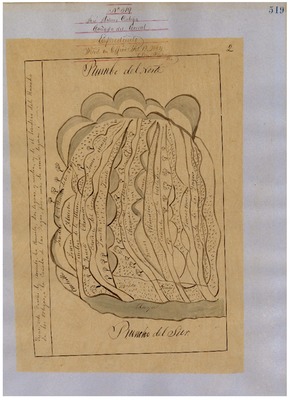
Nuestra Señora del Refugio, Diseños 522, GLO 379, Santa Barbara County, and associated historical documents
Diseños - Hand-drawn Spanish-Mexican map demonstrating the physical boundaries of land granted to Mexican citizens by the Spanish or Mexican.
Expediente – Hand-written Spanish-Mexican land grant document issued to Mexican citizens in Alta California for land in Alta-California.
Work Progress Administration Abstract (WPA Abstract) – A summary document prepared in 1938 under the Work Progress Administration program detailing the history of a rancho beginning with the Spanish-American land through the U.S. patenting process.
Hoffman Notes -- Summary of information concerning claims made for the Rancho lands from the Appendix containing the Table of Land Claims in the Reports of Land Cases by Ogden Hoffman, Volume I, 1862.
Hoffman Table of Land Claims Appendix, Reports on Land Cases, Vol. I, 1862, p. 83, Ogden Hoffman; summary of information concerning claims made for the Rancho lands.
Hornbeck Rancho Detail Sheet – A summary sheet generated from a land patent database that details the history of a rancho, along with the various state and federal agency record numbers relating to the rancho.
Bancroft Notes – Document detailing information and documents regarding a particular rancho found in the Bancroft Archives.
Bancroft Diseños – Hand-drawn Spanish-Mexican map demonstrating the physical boundaries of land granted to Mexican citizens by the Spanish or Mexican governments used in the U.S. District Court proceedings.
Bancroft Plat/Map – A plat or map of the patented rancho prepared by the U.S. Surveyor General.
BLM Land Grant Patent – Hand-written document issued by the U.S. Government providing legal ownership of land previously granted by the Spanish or Mexican government.
BLM Land Patent Detail Sheet – Document using the BLM accession number that provides specific information regarding the patented land of a rancho.
BLM CDI Detail Sheet - Document using the CDI Doc ID that provides specific information concerning the patented land of a rancho.
BLM Survey(s) – Plat(s) prepared by the Office of the U.S. Surveyor General detailing the boundaries of the rancho.
-
 County, and associated historical documents.")
Ojai, Diseño 139, GLO No. 389, Santa Barbara (Ventura) County, and associated historical documents.
National Archives Diseños - Hand-drawn Spanish-Mexican map demonstrating the physical boundaries of land granted to Mexican citizens by the Spanish or Mexican.
Work Progress Administration Abstract (WPA Abstract) – A summary document prepared in 1938 under the U. S. Work Progress Administration program detailing the history of a rancho beginning with the Spanish-American land through the U.S. patenting process.
Bancroft Notes – Document detailing information and documents regarding a rancho found in the Bancroft Archives.
Bancroft Diseños – Hand-drawn Spanish-Mexican map demonstrating the physical boundaries of land granted to Mexican citizens by the Spanish or Mexican governments used in the U.S. District Court proceedings.
Bancroft Plat/Map/Survey – A plat, map or survey of the patented rancho prepared by the U.S. Surveyor General.
BLM Land Patent – Hand-written document issued by the U.S. Government providing legal ownership of land previously granted by the Spanish or Mexican government.
BLM Land Patent Detail Sheet – Document using the BLM accession number that provides specific information regarding the patented land of a rancho.
BLM CDI Detail Sheet - Document using the CDI Doc ID that provides specific information concerning the patented land of a rancho.
BLM Survey(s) – Plat(s) prepared by the Office of the U.S. Surveyor General detailing the boundaries of the rancho.
-

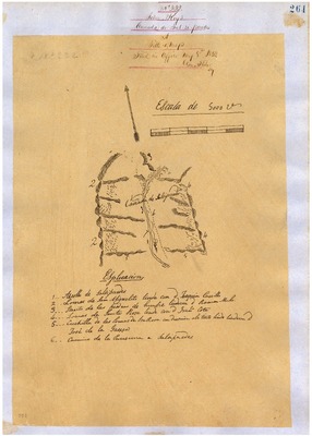
Punta de la Concepción, Diseños 327, GLO 375, Santa Barbara County, and associated historical documents
Diseños - Hand-drawn Spanish-Mexican map demonstrating the physical boundaries of land granted to Mexican citizens by the Spanish or Mexican.
Expediente – Hand-written Spanish-Mexican land grant document issued to Mexican citizens in Alta California for land in Alta-California.
Work Progress Administration Abstract (WPA Abstract) – A summary document prepared in 1938 under the Work Progress Administration program detailing the history of a rancho beginning with the Spanish-American land through the U.S. patenting process.
Hoffman Notes -- Summary of information concerning claims made for the Rancho lands from the Appendix containing the Table of Land Claims in the Reports of Land Cases by Ogden Hoffman, Volume I, 1862.
Hoffman Table of Land Claims Appendix, Reports on Land Cases, Vol. I, 1862, p. 83, Ogden Hoffman; summary of information concerning claims made for the Rancho lands.
Hornbeck Rancho Detail Sheet – A summary sheet generated from a land patent database that details the history of a rancho, along with the various state and federal agency record numbers relating to the rancho.
Bancroft Notes – Document detailing information and documents regarding a particular rancho found in the Bancroft Archives.
Bancroft Diseños – Hand-drawn Spanish-Mexican map demonstrating the physical boundaries of land granted to Mexican citizens by the Spanish or Mexican governments used in the U.S. District Court proceedings.
Bancroft Plat/Map – A plat or map of the patented rancho prepared by the U.S. Surveyor General.
BLM Land Grant Patent – Hand-written document issued by the U.S. Government providing legal ownership of land previously granted by the Spanish or Mexican government.
BLM Land Patent Detail Sheet – Document using the BLM accession number that provides specific information regarding the patented land of a rancho.
BLM CDI Detail Sheet - Document using the CDI Doc ID that provides specific information concerning the patented land of a rancho.
BLM Survey(s) – Plat(s) prepared by the Office of the U.S. Surveyor General detailing the boundaries of the rancho.
-

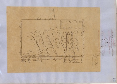
Punta de la Laguna, Diseños 121, GLO 354, Santa Barbara and San Luis Obispo Counties, and associated historical documents
Diseños - Hand-drawn Spanish-Mexican map demonstrating the physical boundaries of land granted to Mexican citizens by the Spanish or Mexican.
Expediente – Hand-written Spanish-Mexican land grant document issued to Mexican citizens in Alta California for land in Alta-California.
Work Progress Administration Abstract (WPA Abstract) – A summary document prepared in 1938 under the Work Progress Administration program detailing the history of a rancho beginning with the Spanish-American land through the U.S. patenting process.
Hoffman Notes -- Summary of information concerning claims made for the Rancho lands from the Appendix containing the Table of Land Claims in the Reports of Land Cases by Ogden Hoffman, Volume I, 1862.
Hoffman Table of Land Claims Appendix, Reports on Land Cases, Vol. I, 1862, p. 83, Ogden Hoffman; summary of information concerning claims made for the Rancho lands.
Hornbeck Rancho Detail Sheet – A summary sheet generated from a land patent database that details the history of a rancho, along with the various state and federal agency record numbers relating to the rancho.
Bancroft Notes – Document detailing information and documents regarding a particular rancho found in the Bancroft Archives.
Bancroft Diseños – Hand-drawn Spanish-Mexican map demonstrating the physical boundaries of land granted to Mexican citizens by the Spanish or Mexican governments used in the U.S. District Court proceedings.
Bancroft Plat/Map – A plat or map of the patented rancho prepared by the U.S. Surveyor General.
BLM Land Grant Patent – Hand-written document issued by the U.S. Government providing legal ownership of land previously granted by the Spanish or Mexican government.
BLM Land Patent Detail Sheet – Document using the BLM accession number that provides specific information regarding the patented land of a rancho.
BLM CDI Detail Sheet - Document using the CDI Doc ID that provides specific information concerning the patented land of a rancho.
BLM Survey(s) – Plat(s) prepared by the Office of the U.S. Surveyor General detailing the boundaries of the rancho.
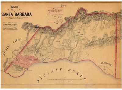
Santa Barbara County Recorded Land Grant Maps – Initial plat prepared U.S. Surveyor General detailing the boundaries of the land grant, township, range, course and distance
-

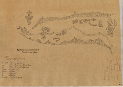
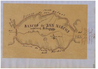
Rancho de San Marcos, Diseños 299, GLO 364, Santa Barbara County, and associated historical documents
Diseños - Hand-drawn Spanish-Mexican map demonstrating the physical boundaries of land granted to Mexican citizens by the Spanish or Mexican.
Expediente – Hand-written Spanish-Mexican land grant document issued to Mexican citizens in Alta California for land in Alta-California.
Work Progress Administration Abstract (WPA Abstract) – A summary document prepared in 1938 under the Work Progress Administration program detailing the history of a rancho beginning with the Spanish-American land through the U.S. patenting process.
Hoffman Notes -- Summary of information concerning claims made for the Rancho lands from the Appendix containing the Table of Land Claims in the Reports of Land Cases by Ogden Hoffman, Volume I, 1862.
Hoffman Table of Land Claims Appendix, Reports on Land Cases, Vol. I, 1862, p. 83, Ogden Hoffman; summary of information concerning claims made for the Rancho lands.
Hornbeck Rancho Detail Sheet – A summary sheet generated from a land patent database that details the history of a rancho, along with the various state and federal agency record numbers relating to the rancho.
Bancroft Notes – Document detailing information and documents regarding a particular rancho found in the Bancroft Archives.
Bancroft Diseños – Hand-drawn Spanish-Mexican map demonstrating the physical boundaries of land granted to Mexican citizens by the Spanish or Mexican governments used in the U.S. District Court proceedings.
Bancroft Plat/Map – A plat or map of the patented rancho prepared by the U.S. Surveyor General.
BLM Land Grant Patent – Hand-written document issued by the U.S. Government providing legal ownership of land previously granted by the Spanish or Mexican government.
BLM Land Patent Detail Sheet – Document using the BLM accession number that provides specific information regarding the patented land of a rancho.
BLM CDI Detail Sheet - Document using the CDI Doc ID that provides specific information concerning the patented land of a rancho.
BLM Survey(s) – Plat(s) prepared by the Office of the U.S. Surveyor General detailing the boundaries of the rancho.
Santa Barbara County Recorded Land Grant Maps – Initial plat prepared by U.S. Surveyor General detailing the land grant the boundaries, township, range, course and distance.
-
, Diseño 512, Ventura (formerly Santa Barbara) County, and associated historical documents.")
Rancho de San Pedro (Chapman), Diseño 512, Ventura (formerly Santa Barbara) County, and associated historical documents.
National Archives Diseños - Hand-drawn Spanish-Mexican map demonstrating the physical boundaries of land granted to Mexican citizens by the Spanish or Mexican.
Work Progress Administration Abstract (WPA Abstract) – A summary document prepared in 1938 under the U. S. Work Progress Administration program detailing the history of a rancho beginning with the Spanish-American land through the U.S. patenting process.
Hoffman Table of Land Claims Appendix, Reports on Land Cases, Vol. I, 1862, Ogden Hoffman – Index of land claims, in chronological order by Diseño number, made to the U.S. Land Commission for rancho land previously granted by the Spanish/Mexican governments in California.
Bancroft Notes – Document detailing information and documents regarding a rancho found in the Bancroft Archives.
Bancroft Diseños – Hand-drawn Spanish-Mexican map demonstrating the physical boundaries of land granted to Mexican citizens by the Spanish or Mexican governments used in the U.S. District Court proceedings.
-

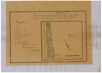
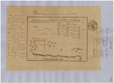
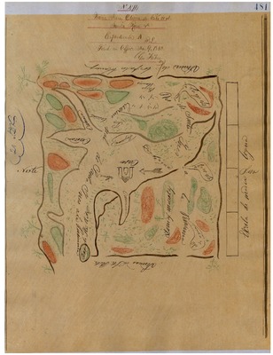
San Carlos de Jonata, Diseños 534, GLO 369, Santa Barbara County, and associated historical documents
Diseños - Hand-drawn Spanish-Mexican map demonstrating the physical boundaries of land granted to Mexican citizens by the Spanish or Mexican.
Expediente – Hand-written Spanish-Mexican land grant document issued to Mexican citizens in Alta California for land in Alta-California.
Work Progress Administration Abstract (WPA Abstract) – A summary document prepared in 1938 under the Work Progress Administration program detailing the history of a rancho beginning with the Spanish-American land through the U.S. patenting process.
Hoffman Notes -- Summary of information concerning claims made for the Rancho lands from the Appendix containing the Table of Land Claims in the Reports of Land Cases by Ogden Hoffman, Volume I, 1862.
Hoffman Table of Land Claims Appendix, Reports on Land Cases, Vol. I, 1862, p. 83, Ogden Hoffman; summary of information concerning claims made for the Rancho lands.
Hornbeck Rancho Detail Sheet – A summary sheet generated from a land patent database that details the history of a rancho, along with the various state and federal agency record numbers relating to the rancho.
Bancroft Notes – Document detailing information and documents regarding a particular rancho found in the Bancroft Archives.
Bancroft Diseños – Hand-drawn Spanish-Mexican map demonstrating the physical boundaries of land granted to Mexican citizens by the Spanish or Mexican governments used in the U.S. District Court proceedings.
Bancroft Plat/Map – A plat or map of the patented rancho prepared by the U.S. Surveyor General.
BLM Land Grant Patent – Hand-written document issued by the U.S. Government providing legal ownership of land previously granted by the Spanish or Mexican government.
BLM Land Patent Detail Sheet – Document using the BLM accession number that provides specific information regarding the patented land of a rancho.
BLM CDI Detail Sheet - Document using the CDI Doc ID that provides specific information concerning the patented land of a rancho.
BLM Survey(s) – Plat(s) prepared by the Office of the U.S. Surveyor General detailing the boundaries of the rancho.
Santa Barbara County Recorded Land Grant Maps – Initial plat prepared by U.S. Surveyor General detailing the land grant the boundaries, township, range, course and distance.
-

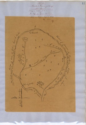
San Julian, Diseños 13, GLO 378, Santa Barbara County, and associated historical documents
Diseños - Hand-drawn Spanish-Mexican map demonstrating the physical boundaries of land granted to Mexican citizens by the Spanish or Mexican.
Expediente – Hand-written Spanish-Mexican land grant document issued to Mexican citizens in Alta California for land in Alta-California.
Work Progress Administration Abstract (WPA Abstract) – A summary document prepared in 1938 under the Work Progress Administration program detailing the history of a rancho beginning with the Spanish-American land through the U.S. patenting process.
Hoffman Notes -- Summary of information concerning claims made for the Rancho lands from the Appendix containing the Table of Land Claims in the Reports of Land Cases by Ogden Hoffman, Volume I, 1862.
Hoffman Table of Land Claims Appendix, Reports on Land Cases, Vol. I, 1862, p. 83, Ogden Hoffman; summary of information concerning claims made for the Rancho lands.
Hornbeck Rancho Detail Sheet – A summary sheet generated from a land patent database that details the history of a rancho, along with the various state and federal agency record numbers relating to the rancho.
Bancroft Notes – Document detailing information and documents regarding a particular rancho found in the Bancroft Archives.
Bancroft Diseños – Hand-drawn Spanish-Mexican map demonstrating the physical boundaries of land granted to Mexican citizens by the Spanish or Mexican governments used in the U.S. District Court proceedings.
Bancroft Plat/Map – A plat or map of the patented rancho prepared by the U.S. Surveyor General.
BLM Land Grant Patent – Hand-written document issued by the U.S. Government providing legal ownership of land previously granted by the Spanish or Mexican government.
BLM Land Patent Detail Sheet – Document using the BLM accession number that provides specific information regarding the patented land of a rancho.
BLM CDI Detail Sheet - Document using the CDI Doc ID that provides specific information concerning the patented land of a rancho.
BLM Survey(s) – Plat(s) prepared by the Office of the U.S. Surveyor General detailing the boundaries of the rancho.
Santa Barbara County Recorded Land Grant Maps – Initial plat prepared by U.S. Surveyor General detailing the land grant the boundaries, township, range, course and distance
-

San Marcos, Diseños 299, GLO 364, Santa Barbara County, and associated historical documents
Diseños - Hand-drawn Spanish-Mexican map demonstrating the physical boundaries of land granted to Mexican citizens by the Spanish or Mexican.
Expediente – Hand-written Spanish-Mexican land grant document issued to Mexican citizens in Alta California for land in Alta-California.
Work Progress Administration Abstract (WPA Abstract) – A summary document prepared in 1938 under the Work Progress Administration program detailing the history of a rancho beginning with the Spanish-American land through the U.S. patenting process.
Hoffman Notes -- Summary of information concerning claims made for the Rancho lands from the Appendix containing the Table of Land Claims in the Reports of Land Cases by Ogden Hoffman, Volume I, 1862.
Hoffman Table of Land Claims Appendix, Reports on Land Cases, Vol. I, 1862, p. 83, Ogden Hoffman; summary of information concerning claims made for the Rancho lands.
Hornbeck Rancho Detail Sheet – A summary sheet generated from a land patent database that details the history of a rancho, along with the various state and federal agency record numbers relating to the rancho.
Bancroft Notes – Document detailing information and documents regarding a particular rancho found in the Bancroft Archives.
Bancroft Diseños – Hand-drawn Spanish-Mexican map demonstrating the physical boundaries of land granted to Mexican citizens by the Spanish or Mexican governments used in the U.S. District Court proceedings.
Bancroft Plat/Map – A plat or map of the patented rancho prepared by the U.S. Surveyor General.
BLM Land Grant Patent – Hand-written document issued by the U.S. Government providing legal ownership of land previously granted by the Spanish or Mexican government.
BLM Land Patent Detail Sheet – Document using the BLM accession number that provides specific information regarding the patented land of a rancho.
BLM CDI Detail Sheet - Document using the CDI Doc ID that provides specific information concerning the patented land of a rancho.
BLM Survey(s) – Plat(s) prepared by the Office of the U.S. Surveyor General detailing the boundaries of the rancho.
Santa Barbara County Recorded Land Grant Maps – Initial plat prepared by U.S. Surveyor General detailing the land grant the boundaries, township, range, course and distance.
-
, Diseño 472, GLO No. 394, Ventura (formerly Santa Barbara) County, and associated historical documents.")
San Miguel (Olivas & Lorenzana), Diseño 472, GLO No. 394, Ventura (formerly Santa Barbara) County, and associated historical documents.
Work Progress Administration Abstract (WPA Abstract) – A summary document prepared in 1938 under the U.S. Work Progress Administration program detailing the history of a rancho beginning with the Spanish-American land grant through the U.S. patenting process.
Bancroft Notes – Document detailing information and documents regarding a rancho found in the Bancroft Archives.
BLM Land Patent – Hand-written document issued by the U.S. Government providing legal ownership of land previously granted by the Spanish or Mexican government.
BLM Land Patent Detail Sheet – Document using the BLM accession number that provides specific information regarding the patented land of a rancho.
BLM CDI Detail Sheet - Document using the CDI Doc ID that provides specific information concerning the patented land of a rancho.
-
, and associated historical documents")
Santa Ana, Diseños 494, GLO 388, Ventura County (formerly part of Santa Barbara County), and associated historical documents
Diseños - Hand-drawn Spanish-Mexican map demonstrating the physical boundaries of land granted to Mexican citizens by the Spanish or Mexican.
Expediente – Hand-written Spanish-Mexican land grant document issued to Mexican citizens in Alta California for land in Alta-California.
Work Progress Administration Abstract (WPA Abstract) – A summary document prepared in 1938 under the Work Progress Administration program detailing the history of a rancho beginning with the Spanish-American land through the U.S. patenting process.
Hoffman Notes -- Summary of information concerning claims made for the Rancho lands from the Appendix containing the Table of Land Claims in the Reports of Land Cases by Ogden Hoffman, Volume I, 1862.
Hoffman Table of Land Claims Appendix, Reports on Land Cases, Vol. I, 1862, p. 83, Ogden Hoffman; summary of information concerning claims made for the Rancho lands.
Hornbeck Rancho Detail Sheet – A summary sheet generated from a land patent database that details the history of a rancho, along with the various state and federal agency record numbers relating to the rancho.
Bancroft Notes – Document detailing information and documents regarding a particular rancho found in the Bancroft Archives.
Bancroft Diseños – Hand-drawn Spanish-Mexican map demonstrating the physical boundaries of land granted to Mexican citizens by the Spanish or Mexican governments used in the U.S. District Court proceedings.
Bancroft Plat/Map – A plat or map of the patented rancho prepared by the U.S. Surveyor General.
BLM Land Grant Patent – Hand-written document issued by the U.S. Government providing legal ownership of land previously granted by the Spanish or Mexican government.
BLM Land Patent Detail Sheet – Document using the BLM accession number that provides specific information regarding the patented land of a rancho.
BLM CDI Detail Sheet - Document using the CDI Doc ID that provides specific information concerning the patented land of a rancho.
BLM Survey(s) – Plat(s) prepared by the Office of the U.S. Surveyor General detailing the boundaries of the rancho.
Santa Barbara County Recorded Land Grant Maps – Initial plat prepared by U.S. Surveyor General detailing the land grant the boundaries, township, range, course and distance.
-

Santa Barbara Pueblo Lands, Diseños 543, GLO 386, Santa Barbara County, and associated historical documents
Diseños - Hand-drawn Spanish-Mexican map demonstrating the physical boundaries of land granted to Mexican citizens by the Spanish or Mexican.
Expediente – Hand-written Spanish-Mexican land grant document issued to Mexican citizens in Alta California for land in Alta-California.
Work Progress Administration Abstract (WPA Abstract) – A summary document prepared in 1938 under the Work Progress Administration program detailing the history of a rancho beginning with the Spanish-American land through the U.S. patenting process.
Hoffman Notes -- Summary of information concerning claims made for the Rancho lands from the Appendix containing the Table of Land Claims in the Reports of Land Cases by Ogden Hoffman, Volume I, 1862.
Hoffman Table of Land Claims Appendix, Reports on Land Cases, Vol. I, 1862, p. 83, Ogden Hoffman; summary of information concerning claims made for the Rancho lands.
Hornbeck Rancho Detail Sheet – A summary sheet generated from a land patent database that details the history of a rancho, along with the various state and federal agency record numbers relating to the rancho.
Bancroft Notes – Document detailing information and documents regarding a particular rancho found in the Bancroft Archives.
Bancroft Diseños – Hand-drawn Spanish-Mexican map demonstrating the physical boundaries of land granted to Mexican citizens by the Spanish or Mexican governments used in the U.S. District Court proceedings.
Bancroft Plat/Map – A plat or map of the patented rancho prepared by the U.S. Surveyor General.
BLM Land Grant Patent – Hand-written document issued by the U.S. Government providing legal ownership of land previously granted by the Spanish or Mexican government.
BLM Land Patent Detail Sheet – Document using the BLM accession number that provides specific information regarding the patented land of a rancho.
BLM CDI Detail Sheet - Document using the CDI Doc ID that provides specific information concerning the patented land of a rancho.
BLM Survey(s) – Plat(s) prepared by the Office of the U.S. Surveyor General detailing the boundaries of the rancho.
Santa Barbara County Recorded Land Grant Maps – Initial plat prepared by U.S. Surveyor General detailing the land grant the boundaries, township, range, course and distance.
-
![Santa Clara del Norte, Diseños 389, GLO 402, Ventura County [formerly part of Santa Barbara County], and associated historical documents](https://digitalcommons.csumb.edu/hornbeck_usa_4_a_sabc/1038/thumbnail.jpg "Santa Clara del Norte, Diseños 389, GLO 402, Ventura County [formerly part of Santa Barbara County], and associated historical documents")
Santa Clara del Norte, Diseños 389, GLO 402, Ventura County [formerly part of Santa Barbara County], and associated historical documents
Diseños - Hand-drawn Spanish-Mexican map demonstrating the physical boundaries of land granted to Mexican citizens by the Spanish or Mexican.
Expediente – Hand-written Spanish-Mexican land grant document issued to Mexican citizens in Alta California for land in Alta-California.
Work Progress Administration Abstract (WPA Abstract) – A summary document prepared in 1938 under the Work Progress Administration program detailing the history of a rancho beginning with the Spanish-American land through the U.S. patenting process.
Hoffman Notes -- Summary of information concerning claims made for the Rancho lands from the Appendix containing the Table of Land Claims in the Reports of Land Cases by Ogden Hoffman, Volume I, 1862.
Hoffman Table of Land Claims Appendix, Reports on Land Cases, Vol. I, 1862, p. 83, Ogden Hoffman; summary of information concerning claims made for the Rancho lands.
Hornbeck Rancho Detail Sheet – A summary sheet generated from a land patent database that details the history of a rancho, along with the various state and federal agency record numbers relating to the rancho.
Bancroft Notes – Document detailing information and documents regarding a particular rancho found in the Bancroft Archives.
Bancroft Diseños – Hand-drawn Spanish-Mexican map demonstrating the physical boundaries of land granted to Mexican citizens by the Spanish or Mexican governments used in the U.S. District Court proceedings.
Bancroft Plat/Map – A plat or map of the patented rancho prepared by the U.S. Surveyor General.
BLM Land Grant Patent – Hand-written document issued by the U.S. Government providing legal ownership of land previously granted by the Spanish or Mexican government.
BLM Land Patent Detail Sheet – Document using the BLM accession number that provides specific information regarding the patented land of a rancho.
BLM CDI Detail Sheet - Document using the CDI Doc ID that provides specific information concerning the patented land of a rancho.
BLM Survey(s) – Plat(s) prepared by the Office of the U.S. Surveyor General detailing the boundaries of the rancho.
Santa Barbara County Recorded Land Grant Maps – Initial plat prepared by U.S. Surveyor General detailing the land grant the boundaries, township, range, course and distance.
-
, Diseño 475, GLO No. 463, Los Angeles (formerly Santa Barbara) County, and associated historical documents.")
Santa Gertrudes (Colima), Diseño 475, GLO No. 463, Los Angeles (formerly Santa Barbara) County, and associated historical documents.
National Archives Diseños - Hand-drawn Spanish-Mexican map demonstrating the physical boundaries of land granted to Mexican citizens by the Spanish or Mexican.
National Archives Expediente – Hand-written Spanish-Mexican land grant document issued to Spanish or Mexican citizens for land located in Alta-California.
Work Progress Administration Abstract (WPA Abstract) – A summary document prepared in 1938 under the U. S. Work Progress Administration program detailing the history of a rancho beginning with the Spanish-American land through the U.S. patenting process.
Bancroft Notes – Document detailing information and documents regarding a rancho found in the Bancroft Archives.
Bancroft Diseños – Hand-drawn Spanish-Mexican map demonstrating the physical boundaries of land granted to Mexican citizens by the Spanish or Mexican governments used in the U.S. District Court proceedings.
Bancroft Plat/Map/Survey – A plat, map or survey of the patented rancho prepared by the U.S. Surveyor General.
BLM Land Patent – Hand-written document issued by the U.S. Government providing legal ownership of land previously granted by the Spanish or Mexican government.
BLM Land Patent Detail Sheet – Document using the BLM accession number that provides specific information regarding the patented land of a rancho.
BLM CDI Detail Sheet - Document using the CDI Doc ID that provides specific information concerning the patented land of a rancho.
-
![Santa Paula y Saticoy, Diseños 550, GLO 395, Ventura County [Formerly Santa Barbara County], and associated historical documents](https://digitalcommons.csumb.edu/hornbeck_usa_4_a_sabc/1039/thumbnail.jpg "Santa Paula y Saticoy, Diseños 550, GLO 395, Ventura County [Formerly Santa Barbara County], and associated historical documents")
Santa Paula y Saticoy, Diseños 550, GLO 395, Ventura County [Formerly Santa Barbara County], and associated historical documents
Diseños - Hand-drawn Spanish-Mexican map demonstrating the physical boundaries of land granted to Mexican citizens by the Spanish or Mexican.
Expediente – Hand-written Spanish-Mexican land grant document issued to Mexican citizens in Alta California for land in Alta-California.
Work Progress Administration Abstract (WPA Abstract) – A summary document prepared in 1938 under the Work Progress Administration program detailing the history of a rancho beginning with the Spanish-American land through the U.S. patenting process.
Hoffman Notes -- Summary of information concerning claims made for the Rancho lands from the Appendix containing the Table of Land Claims in the Reports of Land Cases by Ogden Hoffman, Volume I, 1862.
Hoffman Table of Land Claims Appendix, Reports on Land Cases, Vol. I, 1862, p. 83, Ogden Hoffman; summary of information concerning claims made for the Rancho lands.
Hornbeck Rancho Detail Sheet – A summary sheet generated from a land patent database that details the history of a rancho, along with the various state and federal agency record numbers relating to the rancho.
Bancroft Notes – Document detailing information and documents regarding a particular rancho found in the Bancroft Archives.
Bancroft Diseños – Hand-drawn Spanish-Mexican map demonstrating the physical boundaries of land granted to Mexican citizens by the Spanish or Mexican governments used in the U.S. District Court proceedings.
Bancroft Plat/Map – A plat or map of the patented rancho prepared by the U.S. Surveyor General.
BLM Land Grant Patent – Hand-written document issued by the U.S. Government providing legal ownership of land previously granted by the Spanish or Mexican government.
BLM Land Patent Detail Sheet – Document using the BLM accession number that provides specific information regarding the patented land of a rancho.
BLM CDI Detail Sheet - Document using the CDI Doc ID that provides specific information concerning the patented land of a rancho.
BLM Survey(s) – Plat(s) prepared by the Office of the U.S. Surveyor General detailing the boundaries of the rancho.
Santa Barbara County Recorded Land Grant Maps – Initial plat prepared by U.S. Surveyor General detailing the land grant the boundaries, township, range, course and distance.
-
, Diseños 542, GLO 371, Santa Barbara County, and associated historical documents")
Santa Rita (Malo), Diseños 542, GLO 371, Santa Barbara County, and associated historical documents
Diseños - Hand-drawn Spanish-Mexican map demonstrating the physical boundaries of land granted to Mexican citizens by the Spanish or Mexican.
Expediente – Hand-written Spanish-Mexican land grant document issued to Mexican citizens in Alta California for land in Alta-California.
Work Progress Administration Abstract (WPA Abstract) – A summary document prepared in 1938 under the Work Progress Administration program detailing the history of a rancho beginning with the Spanish-American land through the U.S. patenting process.
Hoffman Notes -- Summary of information concerning claims made for the Rancho lands from the Appendix containing the Table of Land Claims in the Reports of Land Cases by Ogden Hoffman, Volume I, 1862.
Hoffman Table of Land Claims Appendix, Reports on Land Cases, Vol. I, 1862, p. 83, Ogden Hoffman; summary of information concerning claims made for the Rancho lands.
Hornbeck Rancho Detail Sheet – A summary sheet generated from a land patent database that details the history of a rancho, along with the various state and federal agency record numbers relating to the rancho.
Bancroft Notes – Document detailing information and documents regarding a particular rancho found in the Bancroft Archives.
Bancroft Diseños – Hand-drawn Spanish-Mexican map demonstrating the physical boundaries of land granted to Mexican citizens by the Spanish or Mexican governments used in the U.S. District Court proceedings.
Bancroft Plat/Map – A plat or map of the patented rancho prepared by the U.S. Surveyor General.
BLM Land Grant Patent – Hand-written document issued by the U.S. Government providing legal ownership of land previously granted by the Spanish or Mexican government.
BLM Land Patent Detail Sheet – Document using the BLM accession number that provides specific information regarding the patented land of a rancho.
BLM CDI Detail Sheet - Document using the CDI Doc ID that provides specific information concerning the patented land of a rancho.
BLM Survey(s) – Plat(s) prepared by the Office of the U.S. Surveyor General detailing the boundaries of the rancho.
Santa Barbara County Recorded Land Grant Maps – Initial plat prepared by U.S. Surveyor General detailing the land grant the boundaries, township, range, course and distance.
-
, Diseños 474, GLO 370, Santa Rosa (Cota), and associated historical documents")
Santa Rosa (Cota), Diseños 474, GLO 370, Santa Rosa (Cota), and associated historical documents
Diseños - Hand-drawn Spanish-Mexican map demonstrating the physical boundaries of land granted to Mexican citizens by the Spanish or Mexican.
Expediente – Hand-written Spanish-Mexican land grant document issued to Mexican citizens in Alta California for land in Alta-California.
Work Progress Administration Abstract (WPA Abstract) – A summary document prepared in 1938 under the Work Progress Administration program detailing the history of a rancho beginning with the Spanish-American land through the U.S. patenting process.
Hoffman Notes -- Summary of information concerning claims made for the Rancho lands from the Appendix containing the Table of Land Claims in the Reports of Land Cases by Ogden Hoffman, Volume I, 1862.
Hoffman Table of Land Claims Appendix, Reports on Land Cases, Vol. I, 1862, p. 83, Ogden Hoffman; summary of information concerning claims made for the Rancho lands.
Hornbeck Rancho Detail Sheet – A summary sheet generated from a land patent database that details the history of a rancho, along with the various state and federal agency record numbers relating to the rancho.
Bancroft Notes – Document detailing information and documents regarding a specific rancho found in the Bancroft Archives.
Bancroft Diseños – Hand-drawn Spanish-Mexican map demonstrating the physical boundaries of land granted to Mexican citizens by the Spanish or Mexican governments used in the U.S. District Court proceedings.
Bancroft Plat/Map – A plat or map of the patented rancho prepared by the U.S. Surveyor General.
BLM Land Grant Patent – Hand-written document issued by the U.S. Government providing legal ownership of land previously granted by the Spanish or Mexican government.
BLM Land Patent Detail Sheet – Document using the BLM accession number that provides specific information regarding the patented land of a rancho.
BLM CDI Detail Sheet - Document using the CDI Doc ID that provides specific information concerning the patented land of a rancho.
BLM Survey(s) – Plat(s) prepared by the Office of the U.S. Surveyor General detailing the boundaries of the rancho.
Santa Barbara County Recorded Land Grant Maps – Initial plat prepared by U.S. Surveyor General detailing the land grant the boundaries, township, range, course and distance.
-
, Diseño 49, GLO No. 397, Ventura (formerly Santa Barbara) County, and associated historical documents.")
Sespe (also called San Cayetano), Diseño 49, GLO No. 397, Ventura (formerly Santa Barbara) County, and associated historical documents.
National Archives Diseños - Hand-drawn Spanish-Mexican map demonstrating the physical boundaries of land granted to Mexican citizens by the Spanish or Mexican.
Work Progress Administration Abstract (WPA Abstract) – A summary document prepared in 1938 under the U. S. Work Progress Administration program detailing the history of a rancho beginning with the Spanish-American land through the U.S. patenting process.
Bancroft Notes – Document detailing information and documents regarding a rancho found in the Bancroft Archives.
Bancroft Diseños – Hand-drawn Spanish-Mexican map demonstrating the physical boundaries of land granted to Mexican citizens by the Spanish or Mexican governments used in the U.S. District Court proceedings.
BLM Land Patent – Hand-written document issued by the U.S. Government providing legal ownership of land previously granted by the Spanish or Mexican government.
BLM Land Patent Detail Sheet – Document using the BLM accession number that provides specific information regarding the patented land of a rancho.
BLM CDI Detail Sheet - Document using the CDI Doc ID that provides specific information concerning the patented land of a rancho.
BLM Survey(s) – Plat(s) prepared by the Office of the U.S. Surveyor General detailing the boundaries of the rancho.
-

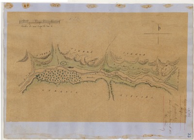
Sisquoc, Diseños 111, GLO 348, Santa Barbara County, and associated historical documents
Diseños - Hand-drawn Spanish-Mexican map demonstrating the physical boundaries of land granted to Mexican citizens by the Spanish or Mexican.
Expediente – Hand-written Spanish-Mexican land grant document issued to Mexican citizens in Alta California for land in Alta-California.
Work Progress Administration Abstract (WPA Abstract) – A summary document prepared in 1938 under the Work Progress Administration program detailing the history of a rancho beginning with the Spanish-American land through the U.S. patenting process.
Hoffman Notes -- Summary of information concerning claims made for the Rancho lands from the Appendix containing the Table of Land Claims in the Reports of Land Cases by Ogden Hoffman, Volume I, 1862.
Hoffman Table of Land Claims Appendix, Reports on Land Cases, Vol. I, 1862, Ogden Hoffman; summary of information concerning claims made for the Rancho lands.
Hornbeck Rancho Detail Sheet – A summary sheet generated from a land patent database that details the history of a rancho, along with the various state and federal agency record numbers relating to the rancho.
Bancroft Notes – Document detailing information and documents regarding a specific rancho found in the Bancroft Archives.
Bancroft Diseños – Hand-drawn Spanish-Mexican map demonstrating the physical boundaries of land granted to Mexican citizens by the Spanish or Mexican governments used in the U.S. District Court proceedings.
Bancroft Plat/Map – A plat or map of the patented rancho prepared by the U.S. Surveyor General.
BLM Land Grant Patent – Hand-written document issued by the U.S. Government providing legal ownership of land previously granted by the Spanish or Mexican government.
BLM Land Patent Detail Sheet – Document using the BLM accession number that provides specific information regarding the patented land of a rancho.
BLM CDI Detail Sheet - Document using the CDI Doc ID that provides specific information concerning the patented land of a rancho.
BLM Survey(s) – Plat(s) prepared by the Office of the U.S. Surveyor General detailing the boundaries of the rancho.
Santa Barbara County Recorded Land Grant Maps – Initial plat prepared by U.S. Surveyor General detailing the land grant the boundaries, township, range, course and distance.
-

Suey, Diseños 41, GLO 360, Santa Barbara and San Luis Obispo Counties, and associated historical documents
Diseños - Hand-drawn Spanish-Mexican map demonstrating the physical boundaries of land granted to Mexican citizens by the Spanish or Mexican.
Expediente – Hand-written Spanish-Mexican land grant document issued to Mexican citizens in Alta California for land in Alta-California.
Work Progress Administration Abstract (WPA Abstract) – A summary document prepared in 1938 under the Work Progress Administration program detailing the history of a rancho beginning with the Spanish-American land through the U.S. patenting process.
Hoffman Notes -- Summary of information concerning claims made for the Rancho lands from the Appendix containing the Table of Land Claims in the Reports of Land Cases by Ogden Hoffman, Volume I, 1862.
Hoffman Table of Land Claims Appendix, Reports on Land Cases, Vol. I, 1862, Ogden Hoffman; summary of information concerning claims made for the Rancho lands.
Hornbeck Rancho Detail Sheet – A summary sheet generated from a land patent database that details the history of a rancho, along with the various state and federal agency record numbers relating to the rancho.
Bancroft Notes – Document detailing information and documents regarding a specific rancho found in the Bancroft Archives.
Bancroft Diseños – Hand-drawn Spanish-Mexican map demonstrating the physical boundaries of land granted to Mexican citizens by the Spanish or Mexican governments used in the U.S. District Court proceedings.
Bancroft Plat/Map – A plat or map of the patented rancho prepared by the U.S. Surveyor General.
BLM Land Grant Patent – Hand-written document issued by the U.S. Government providing legal ownership of land previously granted by the Spanish or Mexican government.
BLM Land Patent Detail Sheet – Document using the BLM accession number that provides specific information regarding the patented land of a rancho.
BLM CDI Detail Sheet - Document using the CDI Doc ID that provides specific information concerning the patented land of a rancho.
BLM Survey(s) – Plat(s) prepared by the Office of the U.S. Surveyor General detailing the boundaries of the rancho.
Santa Barbara County Recorded Land Grant Maps – Initial plat prepared by U.S. Surveyor General detailing the land grant the boundaries, township, range, course and distance.
-
![Temascal, Diseños 521, GLO 398, Ventura and Los Angeles Counties [formerly Part of Santa Barbara County], and related historical documents](https://digitalcommons.csumb.edu/hornbeck_usa_4_a_sabc/1044/thumbnail.jpg "Temascal, Diseños 521, GLO 398, Ventura and Los Angeles Counties [formerly Part of Santa Barbara County], and related historical documents")
Temascal, Diseños 521, GLO 398, Ventura and Los Angeles Counties [formerly Part of Santa Barbara County], and related historical documents
Diseños - Hand-drawn Spanish-Mexican map demonstrating the physical boundaries of land granted to Mexican citizens by the Spanish or Mexican.
Expediente – Hand-written Spanish-Mexican land grant document issued to Mexican citizens in Alta California for land in Alta-California.
Work Progress Administration Abstract (WPA Abstract) – A summary document prepared in 1938 under the Work Progress Administration program detailing the history of a rancho beginning with the Spanish-American land through the U.S. patenting process.
Hoffman Notes -- Summary of information concerning claims made for the Rancho lands from the Appendix containing the Table of Land Claims in the Reports of Land Cases by Ogden Hoffman, Volume I, 1862.
Hoffman Table of Land Claims Appendix, Reports on Land Cases, Vol. I, 1862, Ogden Hoffman; summary of information concerning claims made for the Rancho lands.
Hornbeck Rancho Detail Sheet – A summary sheet generated from a land patent database that details the history of a rancho, along with the various state and federal agency record numbers relating to the rancho.
Bancroft Notes – Document detailing information and documents regarding a specific rancho found in the Bancroft Archives.
Bancroft Diseños – Hand-drawn Spanish-Mexican map demonstrating the physical boundaries of land granted to Mexican citizens by the Spanish or Mexican governments used in the U.S. District Court proceedings.
Bancroft Plat/Map – A plat or map of the patented rancho prepared by the U.S. Surveyor General.
BLM Land Grant Patent – Hand-written document issued by the U.S. Government providing legal ownership of land previously granted by the Spanish or Mexican government.
BLM Land Patent Detail Sheet – Document using the BLM accession number that provides specific information regarding the patented land of a rancho.
BLM CDI Detail Sheet - Document using the CDI Doc ID that provides specific information concerning the patented land of a rancho.
BLM Survey(s) – Plat(s) prepared by the Office of the U.S. Surveyor General detailing the boundaries of the rancho.
Santa Barbara County Recorded Land Grant Maps – Initial plat prepared by U.S. Surveyor General detailing the land grant the boundaries, township, range, course and distance.
-

Tepusquet, Diseños 206, GLO 349, Santa Barbara and San Luis Obispo Counties, and associated historical documents
Diseños - Hand-drawn Spanish-Mexican map demonstrating the physical boundaries of land granted to Mexican citizens by the Spanish or Mexican.
Expediente – Hand-written Spanish-Mexican land grant document issued to Mexican citizens in Alta California for land in Alta-California.
Work Progress Administration Abstract (WPA Abstract) – A summary document prepared in 1938 under the Work Progress Administration program detailing the history of a rancho beginning with the Spanish-American land through the U.S. patenting process.
Hoffman Notes -- Summary of information concerning claims made for the Rancho lands from the Appendix containing the Table of Land Claims in the Reports of Land Cases by Ogden Hoffman, Volume I, 1862.
Hoffman Table of Land Claims Appendix, Reports on Land Cases, Vol. I, 1862, Ogden Hoffman; summary of information concerning claims made for the Rancho lands.
Hornbeck Rancho Detail Sheet – A summary sheet generated from a land patent database that details the history of a rancho, along with the various state and federal agency record numbers relating to the rancho.
Bancroft Notes – Document detailing information and documents regarding a specific rancho found in the Bancroft Archives.
Bancroft Diseños – Hand-drawn Spanish-Mexican map demonstrating the physical boundaries of land granted to Mexican citizens by the Spanish or Mexican governments used in the U.S. District Court proceedings.
Bancroft Plat/Map – A plat or map of the patented rancho prepared by the U.S. Surveyor General.
BLM Land Grant Patent – Hand-written document issued by the U.S. Government providing legal ownership of land previously granted by the Spanish or Mexican government.
BLM Land Patent Detail Sheet – Document using the BLM accession number that provides specific information regarding the patented land of a rancho.
BLM CDI Detail Sheet - Document using the CDI Doc ID that provides specific information concerning the patented land of a rancho.
BLM Survey(s) – Plat(s) prepared by the Office of the U.S. Surveyor General detailing the boundaries of the rancho.
Santa Barbara County Recorded Land Grant Maps – Initial plat prepared by U.S. Surveyor General detailing the land grant the boundaries, township, range, course and distance.
Printing is not supported at the primary Gallery Thumbnail page. Please first navigate to a specific Image before printing.